EP1853082A2 - System and method to perform network node localization training using a mobile node - Google Patents
System and method to perform network node localization training using a mobile node Download PDFInfo
- Publication number
- EP1853082A2 EP1853082A2 EP07009124A EP07009124A EP1853082A2 EP 1853082 A2 EP1853082 A2 EP 1853082A2 EP 07009124 A EP07009124 A EP 07009124A EP 07009124 A EP07009124 A EP 07009124A EP 1853082 A2 EP1853082 A2 EP 1853082A2
- Authority
- EP
- European Patent Office
- Prior art keywords
- node
- mobile node
- stationary
- network
- location
- Prior art date
- Legal status (The legal status is an assumption and is not a legal conclusion. Google has not performed a legal analysis and makes no representation as to the accuracy of the status listed.)
- Granted
Links
- 238000000034 method Methods 0.000 title claims abstract description 59
- 230000004807 localization Effects 0.000 title claims abstract description 18
- 238000005259 measurement Methods 0.000 claims description 23
- 230000005540 biological transmission Effects 0.000 claims description 7
- 238000012544 monitoring process Methods 0.000 claims description 3
- 230000000007 visual effect Effects 0.000 claims description 3
- 238000012545 processing Methods 0.000 description 12
- 238000011161 development Methods 0.000 description 1
- 239000013589 supplement Substances 0.000 description 1
- 230000003319 supportive effect Effects 0.000 description 1
Images

Classifications
-
- H—ELECTRICITY
- H04—ELECTRIC COMMUNICATION TECHNIQUE
- H04W—WIRELESS COMMUNICATION NETWORKS
- H04W64/00—Locating users or terminals or network equipment for network management purposes, e.g. mobility management
- H04W64/003—Locating users or terminals or network equipment for network management purposes, e.g. mobility management locating network equipment
-
- G—PHYSICS
- G01—MEASURING; TESTING
- G01S—RADIO DIRECTION-FINDING; RADIO NAVIGATION; DETERMINING DISTANCE OR VELOCITY BY USE OF RADIO WAVES; LOCATING OR PRESENCE-DETECTING BY USE OF THE REFLECTION OR RERADIATION OF RADIO WAVES; ANALOGOUS ARRANGEMENTS USING OTHER WAVES
- G01S5/00—Position-fixing by co-ordinating two or more direction or position line determinations; Position-fixing by co-ordinating two or more distance determinations
- G01S5/02—Position-fixing by co-ordinating two or more direction or position line determinations; Position-fixing by co-ordinating two or more distance determinations using radio waves
- G01S5/0249—Determining position using measurements made by a non-stationary device other than the device whose position is being determined
Definitions
- the present invention relates to a system and method to locate at least one stationary node of a wireless network using a mobile node.
- a network may include a number of nodes deployed within a particular geographic area. To maintain the nodes of the network and for other reasons, it may be required that the exact location or position of one or more of the nodes be determined. In this regard, to determine the location of a network node, a localization scheme may be employed to derive the location of the node using certain inter-node measurements.
- some localization schemes Before attempting to derive the location of a network node, some localization schemes first require knowledge of the distance between the network node and other network nodes. If the distance between network nodes is unknown, it may be estimated. In this regard, to estimate the distance between network nodes, certain techniques may be employed, which depend on the hardware capability of the nodes. In one technique, the received signal strength (RSS) between two network nodes may be used to estimate the distance between them. In another technique, the packet success rate (PSR) between a sender node and a receiver node may be used to estimate the distance between the two nodes. However, use of such techniques alone to estimate the distance between two network nodes may not be accurate since the estimated distance may also depend on other parameters of the network as well. For example, to accurately estimate the distance using the received signal strength (RSS), information regarding the particular radio frequency (RF) characteristics of the network environment may also be required.
- RSS received signal strength
- PSR packet success rate
- the present invention provides an exemplary method to train a network system to make better estimates of the distances between the nodes of the network system.
- the exemplary method may be performed prior to network node localization.
- a network installer or other person carries a mobile node unit, which may be similar in terms of capabilities as compared to other network nodes, travels over a predetermined path in the network.
- the predetermined path may be generated, for example, in such a manner so as to provide suitable data for creating an estimator, or alternatively, the predetermined path may be generated randomly.
- the predetermined path may be visually indicated, for example, to the installer as part of a map of the floor plan of the geographic area in which the network nodes are located.
- the network may take measurements, such as, for example, the received signal strength (RSS) between the mobile node and one or more stationary nodes of the network, or the packet success rate (PSR) of transmission(s) between the mobile node and one or more stationary nodes of the network. Thereafter, the measurements taken may be used to provide a more accurate model of the distance between the network nodes.
- RSS received signal strength
- PSR packet success rate
- a mobile node is used to collect data, which is used to estimate the locations of one or more nodes of the network.
- an exemplary system of the present invention may generate a predefined path, which is supplied to a network installer, who takes the mobile node and moves it along the predefined path. As the installer moves along the predefined path, the network takes certain measurements with respect to the mobile node and/or one or more stationary nodes of the network. The measurements obtained by the mobile node or the one or more stationary nodes are then used to provide a more accurate estimate of the location of the one or more nodes of the network.
- a temporary ground truth system may be used to provide a more accurate "true" trajectory of the mobile node as it moves along the predefined path and as measurements are taken with respect to the moving mode node.
- the temporary ground truth system may be, for example, a Lidar, Global Positioning System (GPS), or a stereo camera.
- previous estimates of the distance between one or more nodes of the network, or measurements taken with respect to a previous movement of the mobile node along the predefined path at an earlier time may be used in combination with current estimates and/or current measurements.
- previous estimates of the position of one or more network nodes may be used to iteratively estimate the location, or to formulate a revised predefined path of the mobile node.
- such use of previous estimates and/or previous measurements with respect to a previously-defined path may provide more suitable data to calculate future estimates.
- one or more sensors are used to determine, or at least help determine, the position of the one or more nodes of the network.
- inertial sensors may be used to determine a relative position of the one or more network nodes.
- a relative position may be in respect to another network node, the mobile node, or another known position within the geographic area of the network.
- one or more sensors are used to detect a network parameter with respect to non-moving object.
- an inertial sensor may be used to monitor as certain aspect a stationary user, which is used to estimate a variation in power and/or a packet success rate.
- An exemplary embodiment and/or exemplary method of the present invention is directed to determining a location of at least one stationary node of a wireless network, the exemplary embodiment and/or exemplary method including providing a predetermined path within a geographic space of the wireless network, prior to localization, moving a mobile node along the predetermined path, measuring a network parameter with respect to the mobile node as it moves along the predetermined path, and performing a localization process to estimate the location of the at least one stationary node using the measured network parameter.
- the localization process estimates a distance between the mobile node and the at least one stationary node of the network using the measured network parameter.
- Another exemplary embodiment and/or exemplary method of the present invention is directed to determining a location of at least one stationary node of a wireless network, in which the measured network parameter is a received signal strength (RSS) between the mobile node and the at least one stationary node.
- RSS received signal strength
- Yet another exemplary embodiment and/or exemplary method of the present invention is directed to determining a location of at least one stationary node of a wireless network, in which the measured network parameter is a packet success rate of a transmission between the mobile node and the at least one stationary node.
- Still another exemplary embodiment and/or exemplary method of the present invention is directed to determining a location of at least one stationary node of a wireless network, in which the wireless network includes a wireless sensor network.
- Yet another exemplary embodiment and/or exemplary method of the present invention is directed to determining a location of at least one stationary node of a wireless network, in which the wireless network includes an ad-hoc network.
- Still another exemplary embodiment and/or exemplary method of the present invention is directed to determining a location of at least one stationary node of a wireless network, in which the stationary nodes are configured in a multi-hop topology.
- Yet another exemplary embodiment and/or exemplary method of the present invention is directed to determining a location of at least one stationary node of a wireless network, in which the predetermined path is provided visually as part of a map of the geographic space of the wireless network.
- Still another exemplary embodiment and/or exemplary method of the present invention is directed to determining a location of at least one stationary node of a wireless network, in which a movement of the mobile node is monitored as it moves along the predetermined path in order to provide a recorded trajectory of the mobile node as it moves along the predefined path.
- Yet another exemplary embodiment and/or exemplary method of the present invention is directed to determining a location of at least one stationary node of a wireless network, in which the location is iteratively estimated based on at least one of a previous estimate of the location of the at least one stationary node and a measurement taken with respect to a previous run of the mobile node along the predefined path.
- Still another exemplary embodiment and/or exemplary method of the present invention is directed to determining a location of at least one stationary node of a wireless network, in which a revised predefined path of the mobile node is based on at least one of a previous estimate of the location of the at least one stationary node and a measurement taken with respect to a previous run of the mobile node along the predefined path.
- An exemplary embodiment and/or exemplary method of the present invention is directed to determining a location of at least one stationary node of a wireless sensor network, the exemplary embodiment and/or exemplary method including providing in a visual manner a predetermined path within a geographic space of the wireless sensor network, prior to localization, moving a mobile node along the predetermined path, measuring a network parameter with respect to the mobile node as it moves along the predetermined path, monitoring a movement of the mobile node as it moves along the predetermined path to provide a recorded trajectory of the mobile node as it moves along the predefined path, estimating a distance between the mobile node and the at least one stationary node based on the measured network parameter and the recorded trajectory, and calculating the location of the at least one stationary node based on the estimated distance between the mobile node and the at least one stationary node, in which the location is iteratively calculated based on a measurement taken with respect to a previous run of the mobile node along the predefined path to provide a revised predefined path of the mobile node
- An exemplary embodiment and/or exemplary method of the present invention is directed to a system to geographically locate at least one node of a wireless network, the system including an arrangement to determine a predefined path through a geographic space of the wireless network, a mobile node to communicate with at least one stationary node of the wireless network as the mobile node is moved along the predefined path, an arrangement to estimate a distance between the mobile node and the at least one stationary node based on a measured network parameter, and an arrangement to determine a location of the at least one node based on the estimated distance.
- Another exemplary embodiment and/or exemplary method of the present invention is directed to a system to geographically locate at least one node of a wireless network, in which the measured network parameter includes at least one of a received signal strength (RSS) between the mobile node and the at least one stationary node, and a packet success rate of a transmission between the mobile node and the at least one stationary node.
- RSS received signal strength
- Yet another exemplary embodiment and/or exemplary method of the present invention is directed to a system to geographically locate at least one node of a wireless network, in which the mobile node includes a measuring arrangement to measure the network parameter.
- Still another exemplary embodiment and/or exemplary method of the present invention is directed to a system to geographically locate at least one node of a wireless network, in which the at least one stationary node includes a measuring arrangement to measure the network parameter.
- Yet another exemplary embodiment and/or exemplary method of the present invention is directed to a system to geographically locate at least one node of a wireless network, in which the system further includes an arrangement to monitor a movement of the mobile unit as it moves along the predetermined path.
- Still another exemplary embodiment and/or exemplary method of the present invention is directed to a system to geographically locate at least one node of a wireless network, in which the arrangement to monitor the movement includes a Lidar.
- Yet another exemplary embodiment and/or exemplary method of the present invention is directed to a system to geographically locate at least one node of a wireless network, in which the arrangement to monitor the movement includes a Global Positioning System (GPS).
- GPS Global Positioning System
- Still another exemplary embodiment and/or exemplary method of the present invention is directed to a system to geographically locate at least one node of a wireless network, in which the arrangement to monitor the movement includes a stereo camera.
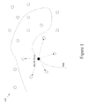
- Figure 1 shows an exemplary wireless network 100, in which a mobile node travels along a predetermined path with respect to a geographic space containing at least one stationary node of the exemplary wireless network 100, and in which certain measurements are taken with respect to the moving node and the least one stationary node so as to provide an estimate of the location of one or more of the network nodes.
- the mobile node is represented by a darkened circle
- the stationary nodes are represented by non-darkened circles
- the predetermined path is represented by a dashed line.
- the exemplary wireless network 100 may be a wireless sensor network located, for example, in an office building, a home, a farm or an airport terminal, in which the network nodes are configured in a multi-hop topology formed, for example, in an ad-hoc manner.
- the at least one stationary node is geographically fixed, at least temporarily, and may be configured, for example, to measure one or more network parameters and/or commmicate with the mobile node.
- the mobile node may be similar in terms of capabilities as compared to the at least one stationary node or the other network nodes, or alternatively, the mobile node may by specially configured with additional or less feature capabilities.
- Figure 2 shows an exemplary method 200 to determine the location of at least one stationary node of the exemplary wireless network 100 of Figure 1.
- a predetermined path is provided within a geographic space of the exemplary wireless network 100, which includes one or more stationary nodes of the exemplary wireless network 100.
- the predetermined path may be provided in any suitable form, including, for example, in a visual form as part of a map of the geographic space of the exemplary wireless network 100, which is supplied to an operator, administrator and/or installer of the network.
- step S202 prior to localization, the mobile node is moved along the predetermined path.
- the mobile node may be carried, for example, by the network installer, who takes the mobile node and proceeds along the predefined path.
- the mobile node may be attached to another movable device that is configured to follow the predefined path.
- step S203 at least one network parameter is measured with respect to the mobile node as it moves along the predetermined path.
- the at least one measured network parameter may include, for example, a received signal strength (RSS) between the mobile node and the at least one stationary node, or a packet success rate of a transmission between the mobile node and the at least one stationary node.
- RSS received signal strength
- other network-related parameters may be measured, which are distance sensitive with respect to the mobile node, or relate to a movement of the mobile node or its location within the geographic space of the exemplary wireless network 100.
- a localization method or process is performed to estimate the location of the at least one stationary node using the at least one measured network parameter.
- the localization method may calculate the distance between the stationary nodes of the exemplary wireless network 100, or between the stationary node and the mobile node, using the measured network parameter and/or previous estimates of the distance between one or more nodes of the exemplary wireless network 100, or measurements taken with respect to a previous movement of the mobile node along the predefined path at an earlier time (i.e., an earlier "run" of the mobile node along the predefined path), which is used in combination with current estimates and/or current measurements.
- previous estimates of the position of one or more network nodes may be used to iteratively estimate the location, or to formulate a revised predefined path of the mobile node.
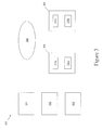
- Figure 3 shows exemplary elements 301 to 306 of an exemplary system 300 to geographically locate one or more nodes of the exemplary wireless network 100.
- the exemplary system 300 includes a first processing arrangement 301, a second processing arrangement 302, a third processing arrangement 303, a stationary node 304, a mobile node 305, and a secondary sensing arrangement 306.
- the first processing arrangement 301 is configured to calculate a predefined path through a geographic space of the wireless network 100, in which at least one stationary node is located.
- the predetermined path may be provided visually, for example, as part of a map of the geographic space of the wireless network 100.
- the predetermined path may be provided as part of a map of the floor plan of the geographic area in which the network nodes are located. Such a map may be supplied, for example, to an operator, administrator and/or installer of the network 100.
- the stationary node 304 and the mobile node 305 communicate with each other and/or measure one or more network parameters as the mobile node 305 is moved along the predefined path.
- the stationary node 304 and/or the mobile node 305 may include a transceiver 304a/305a and one or more network sensors 304b/305b to measure, for example, a received signal strength (RSS) between the mobile node 305 and the stationary node 304, or a packet success rate of a transmission between the mobile node 305 and the stationary node 304.
- RSS received signal strength
- the secondary sensing arrangement 306 provides further measurements, which are used to supplement the network parameters and/or formulate a revised predefined path of the mobile node.
- the secondary sensing arrangement 306 may be provided via a Lidar, a Global Positioning System (GPS), and/or a stereo camera.
- GPS Global Positioning System
- the second processing arrangement 302 estimates a distance between the mobile node 305 and the stationary node 304 based on the measured network parameter
- the third processing arrangement 303 calculates a location of the stationary node 304 and/or other network nodes based on the estimated distance.
- previous estimates of the distance between the mobile node 305 and the stationary node 304, or between one or more other nodes of the network 100, or measurements taken with respect to a previous movement of the mobile node 305 along the predefined path at an earlier time (i.e., an earlier "run" of the mobile node 305 along the predefined path) may be used in combination with current estimates and/or current measurements.
- previous estimates of the position of one or more network nodes may be used to calculate iteratively the location of the stationary node 304 or other networks nodes, or to formulate a revised predefined path of the mobile node 305.
- the estimated distance or location may be a predictive value, which is updated periodically for improved accuracy or to accommodate changing network conditions and/or configuration(s).
- the first processing arrangement 301, the second processing arrangement 302, and the third processing arrangement 303 may be provided as a single processing unit, multiple processing units, or a sub-combination thereof.
- each processing unit may include custom designed control circuitry and/or a microprocessor and program instructions arranged, for example, as part of a computing arrangement, which is supportive, for example, a wide variety of operating and/or application development environments.
Abstract
Description
- The present invention relates to a system and method to locate at least one stationary node of a wireless network using a mobile node.
- A network may include a number of nodes deployed within a particular geographic area. To maintain the nodes of the network and for other reasons, it may be required that the exact location or position of one or more of the nodes be determined. In this regard, to determine the location of a network node, a localization scheme may be employed to derive the location of the node using certain inter-node measurements.
- Before attempting to derive the location of a network node, some localization schemes first require knowledge of the distance between the network node and other network nodes. If the distance between network nodes is unknown, it may be estimated. In this regard, to estimate the distance between network nodes, certain techniques may be employed, which depend on the hardware capability of the nodes. In one technique, the received signal strength (RSS) between two network nodes may be used to estimate the distance between them. In another technique, the packet success rate (PSR) between a sender node and a receiver node may be used to estimate the distance between the two nodes. However, use of such techniques alone to estimate the distance between two network nodes may not be accurate since the estimated distance may also depend on other parameters of the network as well. For example, to accurately estimate the distance using the received signal strength (RSS), information regarding the particular radio frequency (RF) characteristics of the network environment may also be required.
- The present invention provides an exemplary method to train a network system to make better estimates of the distances between the nodes of the network system. In this regard, the exemplary method may be performed prior to network node localization.
- According to an exemplary embodiment of the present invention, prior to localization, a network installer or other person carries a mobile node unit, which may be similar in terms of capabilities as compared to other network nodes, travels over a predetermined path in the network. Here, the predetermined path may be generated, for example, in such a manner so as to provide suitable data for creating an estimator, or alternatively, the predetermined path may be generated randomly. Once generated, the predetermined path may be visually indicated, for example, to the installer as part of a map of the floor plan of the geographic area in which the network nodes are located. While the mobile node is moving on the predetermined path, the network may take measurements, such as, for example, the received signal strength (RSS) between the mobile node and one or more stationary nodes of the network, or the packet success rate (PSR) of transmission(s) between the mobile node and one or more stationary nodes of the network. Thereafter, the measurements taken may be used to provide a more accurate model of the distance between the network nodes.
- According to an exemplary method of the present invention, a mobile node is used to collect data, which is used to estimate the locations of one or more nodes of the network. In this regard, an exemplary system of the present invention may generate a predefined path, which is supplied to a network installer, who takes the mobile node and moves it along the predefined path. As the installer moves along the predefined path, the network takes certain measurements with respect to the mobile node and/or one or more stationary nodes of the network. The measurements obtained by the mobile node or the one or more stationary nodes are then used to provide a more accurate estimate of the location of the one or more nodes of the network.
- According to an exemplary method of the present invention, information from other systems not part of the network is used to provide, or at least help provide, the predefined path and/or take measurements while the mobile node moves along the predefined path. For example, a temporary ground truth system may be used to provide a more accurate "true" trajectory of the mobile node as it moves along the predefined path and as measurements are taken with respect to the moving mode node. In this regard, the temporary ground truth system may be, for example, a Lidar, Global Positioning System (GPS), or a stereo camera.
- According to an exemplary method of the present invention, previous estimates of the distance between one or more nodes of the network, or measurements taken with respect to a previous movement of the mobile node along the predefined path at an earlier time (i.e., an earlier "run" of the mobile node along the predefined path) may be used in combination with current estimates and/or current measurements. For example, previous estimates of the position of one or more network nodes may be used to iteratively estimate the location, or to formulate a revised predefined path of the mobile node. In this regard, such use of previous estimates and/or previous measurements with respect to a previously-defined path may provide more suitable data to calculate future estimates.
- According to an exemplary method of the present invention, one or more sensors are used to determine, or at least help determine, the position of the one or more nodes of the network. For example, inertial sensors may be used to determine a relative position of the one or more network nodes. Here, such a relative position may be in respect to another network node, the mobile node, or another known position within the geographic area of the network.
- According to an exemplary method of the present invention, one or more sensors are used to detect a network parameter with respect to non-moving object. For example, an inertial sensor may be used to monitor as certain aspect a stationary user, which is used to estimate a variation in power and/or a packet success rate.
- An exemplary embodiment and/or exemplary method of the present invention is directed to determining a location of at least one stationary node of a wireless network, the exemplary embodiment and/or exemplary method including providing a predetermined path within a geographic space of the wireless network, prior to localization, moving a mobile node along the predetermined path, measuring a network parameter with respect to the mobile node as it moves along the predetermined path, and performing a localization process to estimate the location of the at least one stationary node using the measured network parameter.
- According to another exemplary embodiment and/or exemplary method of the present invention, the localization process estimates a distance between the mobile node and the at least one stationary node of the network using the measured network parameter.
- Another exemplary embodiment and/or exemplary method of the present invention is directed to determining a location of at least one stationary node of a wireless network, in which the measured network parameter is a received signal strength (RSS) between the mobile node and the at least one stationary node.
- Yet another exemplary embodiment and/or exemplary method of the present invention is directed to determining a location of at least one stationary node of a wireless network, in which the measured network parameter is a packet success rate of a transmission between the mobile node and the at least one stationary node.
- Still another exemplary embodiment and/or exemplary method of the present invention is directed to determining a location of at least one stationary node of a wireless network, in which the wireless network includes a wireless sensor network.
- Yet another exemplary embodiment and/or exemplary method of the present invention is directed to determining a location of at least one stationary node of a wireless network, in which the wireless network includes an ad-hoc network.
- Still another exemplary embodiment and/or exemplary method of the present invention is directed to determining a location of at least one stationary node of a wireless network, in which the stationary nodes are configured in a multi-hop topology.
- Yet another exemplary embodiment and/or exemplary method of the present invention is directed to determining a location of at least one stationary node of a wireless network, in which the predetermined path is provided visually as part of a map of the geographic space of the wireless network.
- Still another exemplary embodiment and/or exemplary method of the present invention is directed to determining a location of at least one stationary node of a wireless network, in which a movement of the mobile node is monitored as it moves along the predetermined path in order to provide a recorded trajectory of the mobile node as it moves along the predefined path.
- Yet another exemplary embodiment and/or exemplary method of the present invention is directed to determining a location of at least one stationary node of a wireless network, in which the location is iteratively estimated based on at least one of a previous estimate of the location of the at least one stationary node and a measurement taken with respect to a previous run of the mobile node along the predefined path.
- Still another exemplary embodiment and/or exemplary method of the present invention is directed to determining a location of at least one stationary node of a wireless network, in which a revised predefined path of the mobile node is based on at least one of a previous estimate of the location of the at least one stationary node and a measurement taken with respect to a previous run of the mobile node along the predefined path.
- An exemplary embodiment and/or exemplary method of the present invention is directed to determining a location of at least one stationary node of a wireless sensor network, the exemplary embodiment and/or exemplary method including providing in a visual manner a predetermined path within a geographic space of the wireless sensor network, prior to localization, moving a mobile node along the predetermined path, measuring a network parameter with respect to the mobile node as it moves along the predetermined path, monitoring a movement of the mobile node as it moves along the predetermined path to provide a recorded trajectory of the mobile node as it moves along the predefined path, estimating a distance between the mobile node and the at least one stationary node based on the measured network parameter and the recorded trajectory, and calculating the location of the at least one stationary node based on the estimated distance between the mobile node and the at least one stationary node, in which the location is iteratively calculated based on a measurement taken with respect to a previous run of the mobile node along the predefined path to provide a revised predefined path of the mobile node.
- An exemplary embodiment and/or exemplary method of the present invention is directed to a system to geographically locate at least one node of a wireless network, the system including an arrangement to determine a predefined path through a geographic space of the wireless network, a mobile node to communicate with at least one stationary node of the wireless network as the mobile node is moved along the predefined path, an arrangement to estimate a distance between the mobile node and the at least one stationary node based on a measured network parameter, and an arrangement to determine a location of the at least one node based on the estimated distance.
- Another exemplary embodiment and/or exemplary method of the present invention is directed to a system to geographically locate at least one node of a wireless network, in which the measured network parameter includes at least one of a received signal strength (RSS) between the mobile node and the at least one stationary node, and a packet success rate of a transmission between the mobile node and the at least one stationary node.
- Yet another exemplary embodiment and/or exemplary method of the present invention is directed to a system to geographically locate at least one node of a wireless network, in which the mobile node includes a measuring arrangement to measure the network parameter.
- Still another exemplary embodiment and/or exemplary method of the present invention is directed to a system to geographically locate at least one node of a wireless network, in which the at least one stationary node includes a measuring arrangement to measure the network parameter.
- Yet another exemplary embodiment and/or exemplary method of the present invention is directed to a system to geographically locate at least one node of a wireless network, in which the system further includes an arrangement to monitor a movement of the mobile unit as it moves along the predetermined path.
- Still another exemplary embodiment and/or exemplary method of the present invention is directed to a system to geographically locate at least one node of a wireless network, in which the arrangement to monitor the movement includes a Lidar.
- Yet another exemplary embodiment and/or exemplary method of the present invention is directed to a system to geographically locate at least one node of a wireless network, in which the arrangement to monitor the movement includes a Global Positioning System (GPS).
- Still another exemplary embodiment and/or exemplary method of the present invention is directed to a system to geographically locate at least one node of a wireless network, in which the arrangement to monitor the movement includes a stereo camera.
-
- Figure 1 shows an exemplary wireless network, in which a mobile node travels along a predetermined path with respect to a geographic space containing at least one stationary node of the exemplary wireless network, and in which certain measurements are taken with respect to the moving node and the at least one stationary node so as to provide an estimate of the distances between one or more of the network nodes.
- Figure 2 shows an exemplary method to determine the location of at least one stationary node of the wireless network of Figure 1.
- Figure 3 shows exemplary elements of an exemplary system to calculate the predefined path through the geographic space of the exemplary wireless network of Figure 1, to measure one or more network parameters as the mobile node is moved along the predefined path, to estimate a distance between the mobile node and the at least one stationary node of the exemplary wireless network based on the measured network parameter, and to calculate a location of the stationary node based on the estimated distance(s).
- Figure 1 shows an exemplary
wireless network 100, in which a mobile node travels along a predetermined path with respect to a geographic space containing at least one stationary node of the exemplarywireless network 100, and in which certain measurements are taken with respect to the moving node and the least one stationary node so as to provide an estimate of the location of one or more of the network nodes. In Figure 1, the mobile node is represented by a darkened circle, the stationary nodes are represented by non-darkened circles, and the predetermined path is represented by a dashed line. - According to an exemplary embodiment of the present invention, the exemplary
wireless network 100 may be a wireless sensor network located, for example, in an office building, a home, a farm or an airport terminal, in which the network nodes are configured in a multi-hop topology formed, for example, in an ad-hoc manner. The at least one stationary node is geographically fixed, at least temporarily, and may be configured, for example, to measure one or more network parameters and/or commmicate with the mobile node. The mobile node may be similar in terms of capabilities as compared to the at least one stationary node or the other network nodes, or alternatively, the mobile node may by specially configured with additional or less feature capabilities. - Figure 2 shows an
exemplary method 200 to determine the location of at least one stationary node of theexemplary wireless network 100 of Figure 1. In step S201, a predetermined path is provided within a geographic space of theexemplary wireless network 100, which includes one or more stationary nodes of theexemplary wireless network 100. Here, the predetermined path may be provided in any suitable form, including, for example, in a visual form as part of a map of the geographic space of theexemplary wireless network 100, which is supplied to an operator, administrator and/or installer of the network. - In step S202, prior to localization, the mobile node is moved along the predetermined path. Here, the mobile node may be carried, for example, by the network installer, who takes the mobile node and proceeds along the predefined path. Alternatively, the mobile node may be attached to another movable device that is configured to follow the predefined path.
- In step S203, at least one network parameter is measured with respect to the mobile node as it moves along the predetermined path. In this regard, the at least one measured network parameter may include, for example, a received signal strength (RSS) between the mobile node and the at least one stationary node, or a packet success rate of a transmission between the mobile node and the at least one stationary node. Alternatively, or in addition, other network-related parameters may be measured, which are distance sensitive with respect to the mobile node, or relate to a movement of the mobile node or its location within the geographic space of the
exemplary wireless network 100. - In step S204, a localization method or process is performed to estimate the location of the at least one stationary node using the at least one measured network parameter. In this regard, the localization method may calculate the distance between the stationary nodes of the
exemplary wireless network 100, or between the stationary node and the mobile node, using the measured network parameter and/or previous estimates of the distance between one or more nodes of theexemplary wireless network 100, or measurements taken with respect to a previous movement of the mobile node along the predefined path at an earlier time (i.e., an earlier "run" of the mobile node along the predefined path), which is used in combination with current estimates and/or current measurements. For example, previous estimates of the position of one or more network nodes may be used to iteratively estimate the location, or to formulate a revised predefined path of the mobile node. - Figure 3 shows
exemplary elements 301 to 306 of anexemplary system 300 to geographically locate one or more nodes of theexemplary wireless network 100. Theexemplary system 300 includes afirst processing arrangement 301, asecond processing arrangement 302, athird processing arrangement 303, astationary node 304, amobile node 305, and asecondary sensing arrangement 306. - The
first processing arrangement 301 is configured to calculate a predefined path through a geographic space of thewireless network 100, in which at least one stationary node is located. Here, the predetermined path may be provided visually, for example, as part of a map of the geographic space of thewireless network 100. In particular, the predetermined path may be provided as part of a map of the floor plan of the geographic area in which the network nodes are located. Such a map may be supplied, for example, to an operator, administrator and/or installer of thenetwork 100. - The
stationary node 304 and themobile node 305 communicate with each other and/or measure one or more network parameters as themobile node 305 is moved along the predefined path. In this regard, thestationary node 304 and/or themobile node 305 may include atransceiver 304a/305a and one ormore network sensors 304b/305b to measure, for example, a received signal strength (RSS) between themobile node 305 and thestationary node 304, or a packet success rate of a transmission between themobile node 305 and thestationary node 304. Thesecondary sensing arrangement 306 provides further measurements, which are used to supplement the network parameters and/or formulate a revised predefined path of the mobile node. In this regard, thesecondary sensing arrangement 306 may be provided via a Lidar, a Global Positioning System (GPS), and/or a stereo camera. - The
second processing arrangement 302 estimates a distance between themobile node 305 and thestationary node 304 based on the measured network parameter, and thethird processing arrangement 303 calculates a location of thestationary node 304 and/or other network nodes based on the estimated distance. Here, previous estimates of the distance between themobile node 305 and thestationary node 304, or between one or more other nodes of thenetwork 100, or measurements taken with respect to a previous movement of themobile node 305 along the predefined path at an earlier time (i.e., an earlier "run" of themobile node 305 along the predefined path) may be used in combination with current estimates and/or current measurements. For example, previous estimates of the position of one or more network nodes may be used to calculate iteratively the location of thestationary node 304 or other networks nodes, or to formulate a revised predefined path of themobile node 305. Accordingly, the estimated distance or location may be a predictive value, which is updated periodically for improved accuracy or to accommodate changing network conditions and/or configuration(s). - According to an exemplary embodiment of the present invention, the
first processing arrangement 301, thesecond processing arrangement 302, and thethird processing arrangement 303 may be provided as a single processing unit, multiple processing units, or a sub-combination thereof. Moreover, each processing unit may include custom designed control circuitry and/or a microprocessor and program instructions arranged, for example, as part of a computing arrangement, which is supportive, for example, a wide variety of operating and/or application development environments.
Claims (20)
- A method of determining a location of at least one stationary node of a wireless network, the method comprising:providing a predetermined path within a geographic space of the wireless network;prior to localization, moving a mobile node along the predetermined path;measuring a network parameter with respect to the mobile node as it moves along the predetermined path; andperforming a localization process to estimate the location of the at least one stationary node using the measured network parameter.
- The method of claim 1, wherein the localization process estimates a distance between the mobile node and the at least one stationary node of the network using the measured network parameter.
- The method of claim 1, wherein the measured network parameter is a received signal strength (RSS) between the mobile node and the at least one stationary node.
- The method of claim 1, wherein the measured network parameter is a packet success rate of a transmission between the mobile node and the at least one stationary node.
- The method of claim 1, wherein the wireless network includes a wireless sensor network.
- The method of claim 1, wherein the wireless network includes an ad-hoc network.
- The method of claim 1, wherein the stationary nodes are configured in a multi-hop topology.
- The method of claim 1, wherein the predetermined path is provided visually as part of a map of the geographic space of the wireless network.
- The method of claim 8, further comprising:monitoring a movement of the mobile node as it moves along the predetermined path in order to provide a recorded trajectory of the mobile node as it moves along the predefined path.
- The method of claim 1, wherein the location is iteratively estimated based on at least one of a previous estimate of the location of the at least one stationary node and a measurement taken with respect to a previous run of the mobile node along the predefined path.
- The method of claim 1, wherein a revised predefined path of the mobile node is based on at least one of a previous estimate of the location of the at least one stationary node and a measurement taken with respect to a previous run of the mobile node along the predefined path.
- A method of determining a location of at least one stationary node of a wireless sensor network, the method comprising:providing in a visual manner a predetermined path within a geographic space of the wireless sensor network;prior to localization, moving a mobile node along the predetermined path;measuring a network parameter with respect to the mobile node as it moves along the predetermined path;monitoring a movement of the mobile node as it moves along the predetermined path to provide a recorded trajectory of the mobile node as it moves along the predefined path;estimating a distance between the mobile node and the at least one stationary node based on the measured network parameter and the recorded trajectory; andcalculating the location of the at least one stationary node based on the estimated distance between the mobile node and the at least one stationary node,wherein the location is iteratively calculated based on a measurement taken with respect to a previous run of the mobile node along the predefined path to provide a revised predefined path of the mobile node.
- A system to geographically locate at least one node of a wireless network, comprising:an arrangement to determine a predefined path through a geographic space of the wireless network;a mobile node to communicate with at least one stationary node of the wireless network as the mobile node is moved along the predefined path;an arrangement to estimate a distance between the mobile node and the at least one stationary node based on a measured network parameter; andan arrangement to determine a location of the at least one node based on the estimated distance.
- The system of claim 13, wherein the measured network parameter includes at least one of a received signal strength (RSS) between the mobile node and the at least one stationary node, and a packet success rate of a transmission between the mobile node and the at least one stationary node.
- The system of claim 13, wherein the mobile node includes a measuring arrangement to measure the network parameter.
- The system of claim 13, wherein the at least one stationary node includes a measuring arrangement to measure the network parameter.
- The system of claim 13, further comprising:an arrangement to monitor a movement of the mobile unit as it moves along the predetermined path.
- The system of claim 17, wherein the arrangement to monitor the movement includes a Lidar.
- The system of claim 17, wherein the arrangement to monitor the movement includes a Global Positioning System (GPS).
- The system of claim 17, wherein the arrangement to monitor the movement includes a stereo camera.
Applications Claiming Priority (1)
| Application Number | Priority Date | Filing Date | Title |
|---|---|---|---|
| US11/418,665 US7362270B2 (en) | 2006-05-05 | 2006-05-05 | System and method to perform network node localization training using a mobile node |
Publications (3)
| Publication Number | Publication Date |
|---|---|
| EP1853082A2 true EP1853082A2 (en) | 2007-11-07 |
| EP1853082A3 EP1853082A3 (en) | 2009-12-09 |
| EP1853082B1 EP1853082B1 (en) | 2012-04-11 |
Family
ID=38426561
Family Applications (1)
| Application Number | Title | Priority Date | Filing Date |
|---|---|---|---|
| EP07009124A Active EP1853082B1 (en) | 2006-05-05 | 2007-05-07 | System and method to perform network node localization training using a mobile node |
Country Status (3)
| Country | Link |
|---|---|
| US (1) | US7362270B2 (en) |
| EP (1) | EP1853082B1 (en) |
| AT (1) | ATE553623T1 (en) |
Cited By (3)
| Publication number | Priority date | Publication date | Assignee | Title |
|---|---|---|---|---|
| CN101424737B (en) * | 2008-12-15 | 2011-10-26 | 北京航空航天大学 | Wireless sensor network signal chart positioning method based on signal strength distance |
| CN101378593B (en) * | 2008-05-06 | 2012-05-30 | 中国科学技术大学苏州研究院 | Method for stably locating wireless sensing network node base on RSSI |
| WO2017067479A1 (en) * | 2015-10-23 | 2017-04-27 | 华为技术有限公司 | Method and device for node location |
Families Citing this family (7)
| Publication number | Priority date | Publication date | Assignee | Title |
|---|---|---|---|---|
| US8055454B2 (en) * | 2005-08-12 | 2011-11-08 | The Invention Science Fund I, Llc | Facilitating mote network configuration and layout using mechanical disturbances |
| KR100947805B1 (en) | 2007-12-05 | 2010-03-15 | 한국전자통신연구원 | Method and equipment for reducing location uncertainty in asset tracking system using wireless sensor network |
| US9497726B2 (en) * | 2010-01-06 | 2016-11-15 | Landis+Gyr Innovations, Inc. | Systems and methods for wireless network routing using radio frequency distance-based virtual node locations |
| US8390444B2 (en) | 2010-04-30 | 2013-03-05 | Hewlett-Packard Development Company, L.P. | Sensor-location system for locating a sensor in a tract covered by an earth-based sensor network |
| WO2011136816A1 (en) | 2010-04-30 | 2011-11-03 | Hewlett-Packard Development Company, L.P. | Determination of a sensor device location in a sensor network |
| JP7066322B2 (en) * | 2017-02-13 | 2022-05-13 | 株式会社トプコン | Surveying system |
| US10470155B2 (en) | 2017-11-30 | 2019-11-05 | Abl Ip Holding Llc | Commissioning of an indoor positioning system using a secondary positioning system |
Citations (2)
| Publication number | Priority date | Publication date | Assignee | Title |
|---|---|---|---|---|
| WO2003010552A2 (en) | 2001-07-24 | 2003-02-06 | Koninklijke Philips Electronics N.V. | Methods and apparatus for determining the position of a transmitter and a mobile communications device |
| WO2003021851A2 (en) | 2001-09-05 | 2003-03-13 | Newbury Networks, Inc. | Position detection and location tracking in a wireless network |
Family Cites Families (5)
| Publication number | Priority date | Publication date | Assignee | Title |
|---|---|---|---|---|
| US3706096A (en) * | 1961-02-02 | 1972-12-12 | Hammack Calvin M | Polystation doppler system tracking of vehicles,measuring displacement and rate thereof and similar applications |
| US4060809A (en) * | 1975-04-09 | 1977-11-29 | Baghdady Elie J | Tracking and position determination system |
| WO1995018432A1 (en) * | 1993-12-30 | 1995-07-06 | Concord, Inc. | Field navigation system |
| US6201497B1 (en) * | 1997-09-30 | 2001-03-13 | Dlb Limited | Enhanced global navigation satellite system |
| US6295022B1 (en) * | 1999-05-25 | 2001-09-25 | Raytheon Company | Apparatus and method for determination of a receiver position |
-
2006
- 2006-05-05 US US11/418,665 patent/US7362270B2/en active Active
-
2007
- 2007-05-07 EP EP07009124A patent/EP1853082B1/en active Active
- 2007-05-07 AT AT07009124T patent/ATE553623T1/en active
Patent Citations (2)
| Publication number | Priority date | Publication date | Assignee | Title |
|---|---|---|---|---|
| WO2003010552A2 (en) | 2001-07-24 | 2003-02-06 | Koninklijke Philips Electronics N.V. | Methods and apparatus for determining the position of a transmitter and a mobile communications device |
| WO2003021851A2 (en) | 2001-09-05 | 2003-03-13 | Newbury Networks, Inc. | Position detection and location tracking in a wireless network |
Cited By (4)
| Publication number | Priority date | Publication date | Assignee | Title |
|---|---|---|---|---|
| CN101378593B (en) * | 2008-05-06 | 2012-05-30 | 中国科学技术大学苏州研究院 | Method for stably locating wireless sensing network node base on RSSI |
| CN101424737B (en) * | 2008-12-15 | 2011-10-26 | 北京航空航天大学 | Wireless sensor network signal chart positioning method based on signal strength distance |
| WO2017067479A1 (en) * | 2015-10-23 | 2017-04-27 | 华为技术有限公司 | Method and device for node location |
| US10356744B2 (en) | 2015-10-23 | 2019-07-16 | Huawei Technologies Co., Ltd. | Node localization method and device |
Also Published As
| Publication number | Publication date |
|---|---|
| US7362270B2 (en) | 2008-04-22 |
| EP1853082B1 (en) | 2012-04-11 |
| US20070257839A1 (en) | 2007-11-08 |
| EP1853082A3 (en) | 2009-12-09 |
| ATE553623T1 (en) | 2012-04-15 |
Similar Documents
| Publication | Publication Date | Title |
|---|---|---|
| EP1853082B1 (en) | System and method to perform network node localization training using a mobile node | |
| CN107111641B (en) | Location estimation for updating a database of location data | |
| EP2805176B1 (en) | Improved positioning system | |
| US9949079B2 (en) | Method of and system for estimating position | |
| EP2517041B1 (en) | Locating electromagnetic signal sources | |
| EP3098620A1 (en) | Locating electromagnetic signal sources | |
| US20140197990A1 (en) | Method for enhancing location identity through incorporation of shorter range communication and sensing (nearlocate) | |
| EP2925064A1 (en) | Method and apparatus for locating a mobile device using the mobile device orientation | |
| US10955518B2 (en) | Method for generating an indoor environment model and a method for determining position data for a location in an indoor environment | |
| KR20130066610A (en) | Determination of a location of an apparatus | |
| KR20150094434A (en) | System for filtering location of Mobile terminal by fusing wi-fi location and sensing information | |
| CN112136019A (en) | System and method for sensor calibration and position determination | |
| WO2016204243A1 (en) | Positioning method and positioning system | |
| US20180292216A1 (en) | Method, device and system for determining an indoor position | |
| Lee et al. | Indoor localization by Kalman filter based combining of UWB-positioning and PDR | |
| KR20160018891A (en) | Methods for estimating location and Apparatuses thereof | |
| Tarrío et al. | Fusion of RSS and inertial measurements for calibration-free indoor pedestrian tracking | |
| Wattananavin et al. | A comparative study of RSSI-based localization methods: RSSI variation caused by human presence and movement | |
| Al-Sabbagh et al. | A centralized multi-floor indoor navigation system for a large mall | |
| Shchekotov et al. | Semi-automatic self-calibrating indoor localization using ble beacon multilateration | |
| Yun et al. | A Bluetooth beacon-based indoor localization and navigation system | |
| Engström et al. | Evaluation and testing of techniques for indoor positioning | |
| Bonthu et al. | An effective algorithm to overcome the practical hindrance for Wi-Fi based indoor positioning system | |
| Lv et al. | Fingerprinting-based localization using accelerometer information in wireless sensor networks | |
| EP3710782B1 (en) | Positioning correction |
Legal Events
| Date | Code | Title | Description |
|---|---|---|---|
| PUAI | Public reference made under article 153(3) epc to a published international application that has entered the european phase |
Free format text: ORIGINAL CODE: 0009012 |
|
| AK | Designated contracting states |
Kind code of ref document: A2 Designated state(s): AT BE BG CH CY CZ DE DK EE ES FI FR GB GR HU IE IS IT LI LT LU LV MC MT NL PL PT RO SE SI SK TR |
|
| AX | Request for extension of the european patent |
Extension state: AL BA HR MK YU |
|
| RIN1 | Information on inventor provided before grant (corrected) |
Inventor name: KESHAVARZIAN, ABTIN Inventor name: SRINIVASAN, BHASKAR Inventor name: VENKATRAMAN, LEKSHMI |
|
| RIN1 | Information on inventor provided before grant (corrected) |
Inventor name: SRINIVASAN, BHASKAR Inventor name: KESHAVARZIAN, ABTIN Inventor name: VENKATRAMAN, LEKSHMI |
|
| PUAL | Search report despatched |
Free format text: ORIGINAL CODE: 0009013 |
|
| AK | Designated contracting states |
Kind code of ref document: A3 Designated state(s): AT BE BG CH CY CZ DE DK EE ES FI FR GB GR HU IE IS IT LI LT LU LV MC MT NL PL PT RO SE SI SK TR |
|
| AX | Request for extension of the european patent |
Extension state: AL BA HR MK RS |
|
| 17P | Request for examination filed |
Effective date: 20100609 |
|
| 17Q | First examination report despatched |
Effective date: 20100712 |
|
| AKX | Designation fees paid |
Designated state(s): AT BE BG CH CY CZ DE DK EE ES FI FR GB GR HU IE IS IT LI LT LU LV MC MT NL PL PT RO SE SI SK TR |
|
| REG | Reference to a national code |
Ref country code: DE Ref legal event code: R079 Ref document number: 602007021818 Country of ref document: DE Free format text: PREVIOUS MAIN CLASS: H04Q0007380000 Ipc: H04W0064000000 |
|
| RIC1 | Information provided on ipc code assigned before grant |
Ipc: H04W 64/00 20090101AFI20110601BHEP |
|
| GRAP | Despatch of communication of intention to grant a patent |
Free format text: ORIGINAL CODE: EPIDOSNIGR1 |
|
| GRAS | Grant fee paid |
Free format text: ORIGINAL CODE: EPIDOSNIGR3 |
|
| GRAA | (expected) grant |
Free format text: ORIGINAL CODE: 0009210 |
|
| AK | Designated contracting states |
Kind code of ref document: B1 Designated state(s): AT BE BG CH CY CZ DE DK EE ES FI FR GB GR HU IE IS IT LI LT LU LV MC MT NL PL PT RO SE SI SK TR |
|
| REG | Reference to a national code |
Ref country code: GB Ref legal event code: FG4D |
|
| REG | Reference to a national code |
Ref country code: CH Ref legal event code: EP |
|
| REG | Reference to a national code |
Ref country code: AT Ref legal event code: REF Ref document number: 553623 Country of ref document: AT Kind code of ref document: T Effective date: 20120415 |
|
| REG | Reference to a national code |
Ref country code: IE Ref legal event code: FG4D |
|
| REG | Reference to a national code |
Ref country code: DE Ref legal event code: R096 Ref document number: 602007021818 Country of ref document: DE Effective date: 20120606 |
|
| REG | Reference to a national code |
Ref country code: NL Ref legal event code: VDEP Effective date: 20120411 |
|
| REG | Reference to a national code |
Ref country code: AT Ref legal event code: MK05 Ref document number: 553623 Country of ref document: AT Kind code of ref document: T Effective date: 20120411 |
|
| LTIE | Lt: invalidation of european patent or patent extension |
Effective date: 20120411 |
|
| PG25 | Lapsed in a contracting state [announced via postgrant information from national office to epo] |
Ref country code: IS Free format text: LAPSE BECAUSE OF FAILURE TO SUBMIT A TRANSLATION OF THE DESCRIPTION OR TO PAY THE FEE WITHIN THE PRESCRIBED TIME-LIMIT Effective date: 20120811 Ref country code: FI Free format text: LAPSE BECAUSE OF FAILURE TO SUBMIT A TRANSLATION OF THE DESCRIPTION OR TO PAY THE FEE WITHIN THE PRESCRIBED TIME-LIMIT Effective date: 20120411 Ref country code: SE Free format text: LAPSE BECAUSE OF FAILURE TO SUBMIT A TRANSLATION OF THE DESCRIPTION OR TO PAY THE FEE WITHIN THE PRESCRIBED TIME-LIMIT Effective date: 20120411 Ref country code: CY Free format text: LAPSE BECAUSE OF FAILURE TO SUBMIT A TRANSLATION OF THE DESCRIPTION OR TO PAY THE FEE WITHIN THE PRESCRIBED TIME-LIMIT Effective date: 20120411 Ref country code: PL Free format text: LAPSE BECAUSE OF FAILURE TO SUBMIT A TRANSLATION OF THE DESCRIPTION OR TO PAY THE FEE WITHIN THE PRESCRIBED TIME-LIMIT Effective date: 20120411 Ref country code: LT Free format text: LAPSE BECAUSE OF FAILURE TO SUBMIT A TRANSLATION OF THE DESCRIPTION OR TO PAY THE FEE WITHIN THE PRESCRIBED TIME-LIMIT Effective date: 20120411 |
|
| PG25 | Lapsed in a contracting state [announced via postgrant information from national office to epo] |
Ref country code: PT Free format text: LAPSE BECAUSE OF FAILURE TO SUBMIT A TRANSLATION OF THE DESCRIPTION OR TO PAY THE FEE WITHIN THE PRESCRIBED TIME-LIMIT Effective date: 20120813 Ref country code: GR Free format text: LAPSE BECAUSE OF FAILURE TO SUBMIT A TRANSLATION OF THE DESCRIPTION OR TO PAY THE FEE WITHIN THE PRESCRIBED TIME-LIMIT Effective date: 20120712 Ref country code: LV Free format text: LAPSE BECAUSE OF FAILURE TO SUBMIT A TRANSLATION OF THE DESCRIPTION OR TO PAY THE FEE WITHIN THE PRESCRIBED TIME-LIMIT Effective date: 20120411 Ref country code: SI Free format text: LAPSE BECAUSE OF FAILURE TO SUBMIT A TRANSLATION OF THE DESCRIPTION OR TO PAY THE FEE WITHIN THE PRESCRIBED TIME-LIMIT Effective date: 20120411 |
|
| PG25 | Lapsed in a contracting state [announced via postgrant information from national office to epo] |
Ref country code: MC Free format text: LAPSE BECAUSE OF NON-PAYMENT OF DUE FEES Effective date: 20120531 Ref country code: BE Free format text: LAPSE BECAUSE OF FAILURE TO SUBMIT A TRANSLATION OF THE DESCRIPTION OR TO PAY THE FEE WITHIN THE PRESCRIBED TIME-LIMIT Effective date: 20120411 |
|
| REG | Reference to a national code |
Ref country code: CH Ref legal event code: PL |
|
| PG25 | Lapsed in a contracting state [announced via postgrant information from national office to epo] |
Ref country code: SK Free format text: LAPSE BECAUSE OF FAILURE TO SUBMIT A TRANSLATION OF THE DESCRIPTION OR TO PAY THE FEE WITHIN THE PRESCRIBED TIME-LIMIT Effective date: 20120411 Ref country code: LI Free format text: LAPSE BECAUSE OF NON-PAYMENT OF DUE FEES Effective date: 20120531 Ref country code: CH Free format text: LAPSE BECAUSE OF NON-PAYMENT OF DUE FEES Effective date: 20120531 Ref country code: AT Free format text: LAPSE BECAUSE OF FAILURE TO SUBMIT A TRANSLATION OF THE DESCRIPTION OR TO PAY THE FEE WITHIN THE PRESCRIBED TIME-LIMIT Effective date: 20120411 Ref country code: NL Free format text: LAPSE BECAUSE OF FAILURE TO SUBMIT A TRANSLATION OF THE DESCRIPTION OR TO PAY THE FEE WITHIN THE PRESCRIBED TIME-LIMIT Effective date: 20120411 Ref country code: RO Free format text: LAPSE BECAUSE OF FAILURE TO SUBMIT A TRANSLATION OF THE DESCRIPTION OR TO PAY THE FEE WITHIN THE PRESCRIBED TIME-LIMIT Effective date: 20120411 Ref country code: CZ Free format text: LAPSE BECAUSE OF FAILURE TO SUBMIT A TRANSLATION OF THE DESCRIPTION OR TO PAY THE FEE WITHIN THE PRESCRIBED TIME-LIMIT Effective date: 20120411 Ref country code: EE Free format text: LAPSE BECAUSE OF FAILURE TO SUBMIT A TRANSLATION OF THE DESCRIPTION OR TO PAY THE FEE WITHIN THE PRESCRIBED TIME-LIMIT Effective date: 20120411 Ref country code: DK Free format text: LAPSE BECAUSE OF FAILURE TO SUBMIT A TRANSLATION OF THE DESCRIPTION OR TO PAY THE FEE WITHIN THE PRESCRIBED TIME-LIMIT Effective date: 20120411 |
|
| PLBE | No opposition filed within time limit |
Free format text: ORIGINAL CODE: 0009261 |
|
| STAA | Information on the status of an ep patent application or granted ep patent |
Free format text: STATUS: NO OPPOSITION FILED WITHIN TIME LIMIT |
|
| REG | Reference to a national code |
Ref country code: IE Ref legal event code: MM4A |
|
| 26N | No opposition filed |
Effective date: 20130114 |
|
| PG25 | Lapsed in a contracting state [announced via postgrant information from national office to epo] |
Ref country code: IE Free format text: LAPSE BECAUSE OF NON-PAYMENT OF DUE FEES Effective date: 20120507 Ref country code: ES Free format text: LAPSE BECAUSE OF FAILURE TO SUBMIT A TRANSLATION OF THE DESCRIPTION OR TO PAY THE FEE WITHIN THE PRESCRIBED TIME-LIMIT Effective date: 20120722 |
|
| REG | Reference to a national code |
Ref country code: DE Ref legal event code: R097 Ref document number: 602007021818 Country of ref document: DE Effective date: 20130114 |
|
| PG25 | Lapsed in a contracting state [announced via postgrant information from national office to epo] |
Ref country code: BG Free format text: LAPSE BECAUSE OF FAILURE TO SUBMIT A TRANSLATION OF THE DESCRIPTION OR TO PAY THE FEE WITHIN THE PRESCRIBED TIME-LIMIT Effective date: 20120711 Ref country code: MT Free format text: LAPSE BECAUSE OF FAILURE TO SUBMIT A TRANSLATION OF THE DESCRIPTION OR TO PAY THE FEE WITHIN THE PRESCRIBED TIME-LIMIT Effective date: 20120411 |
|
| PG25 | Lapsed in a contracting state [announced via postgrant information from national office to epo] |
Ref country code: TR Free format text: LAPSE BECAUSE OF FAILURE TO SUBMIT A TRANSLATION OF THE DESCRIPTION OR TO PAY THE FEE WITHIN THE PRESCRIBED TIME-LIMIT Effective date: 20120411 |
|
| PG25 | Lapsed in a contracting state [announced via postgrant information from national office to epo] |
Ref country code: LU Free format text: LAPSE BECAUSE OF NON-PAYMENT OF DUE FEES Effective date: 20120507 |
|
| PG25 | Lapsed in a contracting state [announced via postgrant information from national office to epo] |
Ref country code: HU Free format text: LAPSE BECAUSE OF FAILURE TO SUBMIT A TRANSLATION OF THE DESCRIPTION OR TO PAY THE FEE WITHIN THE PRESCRIBED TIME-LIMIT Effective date: 20070507 |
|
| REG | Reference to a national code |
Ref country code: FR Ref legal event code: PLFP Year of fee payment: 9 |
|
| REG | Reference to a national code |
Ref country code: FR Ref legal event code: PLFP Year of fee payment: 10 |
|
| REG | Reference to a national code |
Ref country code: FR Ref legal event code: PLFP Year of fee payment: 11 |
|
| REG | Reference to a national code |
Ref country code: FR Ref legal event code: PLFP Year of fee payment: 12 |
|
| PGFP | Annual fee paid to national office [announced via postgrant information from national office to epo] |
Ref country code: IT Payment date: 20220531 Year of fee payment: 16 Ref country code: GB Payment date: 20220523 Year of fee payment: 16 Ref country code: FR Payment date: 20220523 Year of fee payment: 16 |
|
| PGFP | Annual fee paid to national office [announced via postgrant information from national office to epo] |
Ref country code: DE Payment date: 20220725 Year of fee payment: 16 |
|
| REG | Reference to a national code |
Ref country code: DE Ref legal event code: R119 Ref document number: 602007021818 Country of ref document: DE |
|
| GBPC | Gb: european patent ceased through non-payment of renewal fee |
Effective date: 20230507 |