EP2520902A1 - Determining a position of a navigation device - Google Patents
Determining a position of a navigation device Download PDFInfo
- Publication number
- EP2520902A1 EP2520902A1 EP11162466A EP11162466A EP2520902A1 EP 2520902 A1 EP2520902 A1 EP 2520902A1 EP 11162466 A EP11162466 A EP 11162466A EP 11162466 A EP11162466 A EP 11162466A EP 2520902 A1 EP2520902 A1 EP 2520902A1
- Authority
- EP
- European Patent Office
- Prior art keywords
- navigation device
- positioning
- geographical area
- procedures
- procedure
- Prior art date
- Legal status (The legal status is an assumption and is not a legal conclusion. Google has not performed a legal analysis and makes no representation as to the accuracy of the status listed.)
- Granted
Links
Images

Classifications
-
- G—PHYSICS
- G01—MEASURING; TESTING
- G01C—MEASURING DISTANCES, LEVELS OR BEARINGS; SURVEYING; NAVIGATION; GYROSCOPIC INSTRUMENTS; PHOTOGRAMMETRY OR VIDEOGRAMMETRY
- G01C21/00—Navigation; Navigational instruments not provided for in groups G01C1/00 - G01C19/00
- G01C21/005—Navigation; Navigational instruments not provided for in groups G01C1/00 - G01C19/00 with correlation of navigation data from several sources, e.g. map or contour matching
-
- G—PHYSICS
- G01—MEASURING; TESTING
- G01C—MEASURING DISTANCES, LEVELS OR BEARINGS; SURVEYING; NAVIGATION; GYROSCOPIC INSTRUMENTS; PHOTOGRAMMETRY OR VIDEOGRAMMETRY
- G01C21/00—Navigation; Navigational instruments not provided for in groups G01C1/00 - G01C19/00
- G01C21/26—Navigation; Navigational instruments not provided for in groups G01C1/00 - G01C19/00 specially adapted for navigation in a road network
- G01C21/28—Navigation; Navigational instruments not provided for in groups G01C1/00 - G01C19/00 specially adapted for navigation in a road network with correlation of data from several navigational instruments
-
- G—PHYSICS
- G01—MEASURING; TESTING
- G01C—MEASURING DISTANCES, LEVELS OR BEARINGS; SURVEYING; NAVIGATION; GYROSCOPIC INSTRUMENTS; PHOTOGRAMMETRY OR VIDEOGRAMMETRY
- G01C21/00—Navigation; Navigational instruments not provided for in groups G01C1/00 - G01C19/00
- G01C21/38—Electronic maps specially adapted for navigation; Updating thereof
- G01C21/3804—Creation or updating of map data
- G01C21/3833—Creation or updating of map data characterised by the source of data
- G01C21/3844—Data obtained from position sensors only, e.g. from inertial navigation
-
- G—PHYSICS
- G08—SIGNALLING
- G08G—TRAFFIC CONTROL SYSTEMS
- G08G1/00—Traffic control systems for road vehicles
- G08G1/09—Arrangements for giving variable traffic instructions
- G08G1/0962—Arrangements for giving variable traffic instructions having an indicator mounted inside the vehicle, e.g. giving voice messages
- G08G1/0968—Systems involving transmission of navigation instructions to the vehicle
- G08G1/0969—Systems involving transmission of navigation instructions to the vehicle having a display in the form of a map
Definitions
- the present invention relates to a method for determining a position of a navigation device, and to a corresponding navigation device using the method.
- Navigation systems or navigation devices for guiding a user from a starting position, for example a current position of the user, to a destination position are well-known in the art. After having calculated a route from the starting position to the destination position, a current position of the user is determined and based on this current position and the calculated route guidance information may be output to the user by optical and/or acoustical means. For example, a map indicating the current position of the user and the calculated route may be displayed on a display of the navigation device. For determining the guidance information and for detecting, if the user is deviating from the calculated route, an accurate determination of the current position of the user is required.
- the navigation device determines the current position from a plurality of information sources, for example from a satellite based global positioning system like GPS or Galileo, from radio based mobile telecommunications networks, and from telemetric data of the vehicle like tachometer data or speed data.
- a satellite based global positioning system like GPS or Galileo
- radio based mobile telecommunications networks from radio based mobile telecommunications networks
- telemetric data of the vehicle like tachometer data or speed data.
- the provided positioning information from the different sources may be contradictorily or inaccurately.
- a positioning signal from a satellite may be inaccurate due to reflexions or due to a disturbed reception.
- on roads having a plurality of lanes it may be difficult to decide on which lane the vehicle is moving. However, this may be important to guide a driver of the vehicle on the correct lane when the driver has to take a specific exit for following the calculated route.
- a method for determining a position of a navigation device is provided.
- the navigation device is adapted to determine a position of the navigation device based on a plurality of different positioning procedures.
- the plurality of different positioning procedures is provided and each positioning procedure works with a predefined parameter set.
- a plurality of geographical areas is provided and each geographical area is associated with one of the positioning procedures.
- one positioning procedure may be assigned to one or more geographical areas.
- an approximate position of the navigation device is determined. The approximate position may be determined for example based on a single positioning information source, for example a satellite based global positioning system or a mobile telecommunications network.
- the approximate position may comprise a position which is determined with an accuracy of for example a few 100 meters.
- the required accuracy of the approximate position depends on a size of the provided geographical areas, as based on the approximate position one of the plurality of geographical areas in which the navigation device is located is determined. Therefore, the required accuracy of the approximate position may vary on the position of the navigation device. In case the accuracy of the approximate position is not high enough to uniquely identify one of the geographical areas, the whole method may be performed recursively starting with an assumed approximate position. Based on the determined geographical area the associated positioning procedure of the plurality of positioning procedures is selected and used for determining a more accurate position of the navigation device.
- the plurality of different positioning procedures may comprise different positioning algorithms and/or different predefined parameter sets to determine the position of the navigation device.
- the different positioning procedures may rely on the same algorithm and only the predefined parameter sets of the different positioning procedures may be varied.
- an improved positioning can be achieved for different geographical areas.
- At least one parameter of the predefined parameter set defines a weighting for a positioning information source.
- the positioning information source provides a positioning information for the positioning procedure.
- the weighting defines a weight for scaling the positioning information from the positioning information source when the position of the navigation device is determined based on the positioning information of the positioning information source.
- the positioning information sources may comprise a satellite based global positioning device, a steering angle sensor of a steering wheel of the vehicle, a tachometer sensor of the vehicle, an inclination angle sensor of the vehicle indicating for example if the vehicle is driving up or down a hill, a gyro sensor indicating a rotation of the vehicle body, a mobile communications network based positioning device providing positioning information from a radio based mobile communications network, or an electronic toll collect based positioning device providing an information of a position of an electronic toll collect bridge the vehicle is passing.
- the plurality of positioning information may deviate from each other and may be thus contradicting.
- each positioning information source By weighting each of the positioning information delivered from the different positioning information sources, a reliability of each of the positioning information sources can be considered. As the weighting may be different for different geographical areas, each positioning information source can be appropriately considered for determining the position of the navigation device. For example, in areas where a satellite based global positioning information may be corrupted due to reflections in street canyons or may provide a poor reception quality, the weighting of the satellite based global positioning information may be low, whereas in other areas, where a good reception of the satellite based global positioning information is expected, the weighting may be high.
- At least one parameter of the predefined parameter set defines for example a lane width, a number of lanes, or a turning angle threshold to be used by the positioning procedure to determine the position of the navigation device.
- a lane width within one geographical area for example a first city, may be different compared to a lane width of another geographical area, for example of a second city. Therefore, by adapting a lane width depending on the geographical area in which the navigation device is located, a current position or a deviation from a road can be determined more accurately.
- road branches typically may have small angles whereas in other areas road branches typically may have larger angles. Therefore, different turning angle thresholds may be used in different areas to determine if the vehicle is departing from a road at a road branch.
- the vehicle in areas with larger angles at road branches, the vehicle must turn significantly for a detection that the vehicle is exiting the road at the road branch.
- the turn angle threshold may be used to detect a lane change. In some areas a vehicle must turn significantly to detect a lane change, whereas in other areas also slight turns may be considered to detect a lane change.
- the geographical areas may comprise for example an urban region, a rural region, a specific city, a mountainous region, a flat region, a specific country, a specific district area or a specific road. Furthermore, especially within large cities, different geographical areas may be defined within one city. For example for cities having a ring structure like Beijing, the geographical areas may be associated to the rings of the city or even to the ring roads itself.
- the plurality of different positioning procedures comprises a default positioning procedure which is used to determine the position of the navigation device when no geographical area can be determined based on the approximate position of the navigation device.
- the default positioning procedure will be used.
- a navigation device comprises a processing unit, a memory, and a positioning unit.
- the memory is adapted to store a plurality of positioning procedures. Each positioning procedure works on a predefined parameter set which is also stored in the memory.
- the memory is adapted to store a plurality of geographical areas and an association associating each of the geographical areas with one of the positioning procedures. Storing the plurality of geographical areas in the context of the present invention relates to storing geographical information describing the geographical area. For example, the geographical information of a geographical area may describe a contour of the geographical area.
- the positioning unit is adapted to determine an approximate position of the navigation device.
- the positioning unit may determine the approximate position of the navigation device for example based on an absolute positioning information provided for example by a satellite based global positioning system or a mobile communications network based positioning system, or the positioning unit may determine the approximate position based on a previously determined position of the navigation device and a relative change in position based on for example a steering angle sensor or a tachometer sensor of a vehicle, in which the navigation device is installed, or based on an acceleration sensor.
- the processing unit is adapted to determine a position of the navigation device based on the plurality of positioning procedures: The processing unit determines a geographical area in which the navigation device is located based on the approximate position of the navigation device and selects one of the plurality of positioning procedures based on the determined geographical area. Based on the selected positioning procedure, the position of the navigation device is finally determined more accurately.
- the navigation device is adapted to perform the above described method and the embodiments thereof and comprises therefore also the above described advantages.
- the navigation device may comprise a mobile personal navigation device or a vehicle navigation device installed in a vehicle.
- the mobile personal navigation device may be a hand-held device which may be used inside or outside a vehicle.
- the navigation device of the vehicle may comprise a navigation device installed in the vehicle or may be part of an entertainment system or control system of the vehicle.
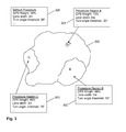
- Fig. 1 shows a navigation device 100 comprising a positioning unit 101 connected to a receiver 102, a processing unit 103 and a memory 104.
- the navigation device 100 may comprise furthermore a display, a keypad, a loudspeaker and other components which are not shown for reasons of clarity.
- the receiver 102 may be adapted to receive positioning information from a satellite based positioning system 105, a mobile communications network based positioning system 106 and/or an electronic toll collect based positioning system 107.
- the positioning unit 101 may furthermore be coupled to sensors of a vehicle, in which the navigation device 100 is mounted.
- the sensors may comprise for example a tachometer sensor indicating a current speed of the vehicle or a distance the vehicle is moving, a steering angle sensor indicating a current steering angle of the vehicle, an inclination angle sensor indicating an inclination angle the vehicle is driving up or down, a gyro sensor indicating a rotation of the vehicle body and an acceleration sensor indicating a current acceleration of the vehicle.
- a rough or approximate position of the navigation device 100 is determined.
- the approximate position may be determined based on the satellite global positioning system (GPS) 105, the mobile communications system 106, the electronic toll collect system 107 when the vehicle is for example crossing a toll collect bridge, or may be determined based on a previously determined position and an offset determined based on a tachometer signal and/ or a steering angle signal of the vehicle or based on an acceleration sensor provided in the vehicle or the navigation device 100.
- GPS satellite global positioning system
- the determined approximate position is used to determine in which geographical area the navigation system is located.
- a map of a routing area 300 of the navigation device 100 may provide specific geographical areas A, B and C. A lot more areas may be provided, but for reasons of clarity in Fig. 3 only three areas are indicated. Furthermore, some areas of the routing area 300 may not be assigned to a specific geographical area as indicated by the area having no area letter in Fig. 3 .
- a positing procedure which is associated with the determined geographical area or region is selected.
- positioning procedures 301 to 304 are provided.
- Positioning procedure 301 is associated with geographical area A
- positioning procedure 302 is associated with geographical area B
- positioning procedure 303 is associated with geographical area C.
- the default positioning procedure 304 is provided and to be used for the remaining areas of the routing area 300.
- the positioning procedure may comprise a specific part of software which has to be used for determining the position of the navigation system or may comprise a specific parameter set which has to be used by a generic software. However, even a specific software and a specific parameter set may be used in combination.
- an accurate position of the navigation device which is more accurate than the approximate position, is determined based on the selected positioning procedure.
- the selected positioning procedure uses a GPS weight of 15%, assumes a lane width for this region of 5 meters and uses a turn angle threshold of 30°.
- Further parameters may be defined by the positioning procedures, for example, a weight for using positioning information of another satellite based positioning system, for example Galileo, a weight for using positioning information based on a mobile telecommunications network, or a weight for using positioning information based on an electronic toll collect system.
- a weight for an inclination angle sensor may be part of the positioning procedure.
- the inclination angle it may be determined on which lane a vehicle is driving when two lanes are running close in parallel, one lane going up a hill and the other lane going down. Further, when driving on a toll road having toll collect bridges for monitoring vehicles and collecting toll, an accurate position of the vehicle can be determined when the vehicle is crossing a toll collect bridge. Furthermore, when two roads are running close in parallel, one road being a toll road and the other being a toll-free road, it may be determined based on the toll collect system if the vehicle is driving on the toll road or on the toll-free road.
- step 202 When in step 202 no specific geographical area could be determined which means in the example of Fig. 3 that the vehicle is in none of the areas A-C, in step 203 the default positioning procedure 304 is selected for determining the exact position of the vehicle in step 204.
- a gyro sensor and an inclination angle sensor may be comprised by the navigation device 100 and thus an improved positioning may be accomplished also in a hand-held navigation device being used for walking or hiking or in a vehicle without being connected to sensors of the vehicle.
Abstract
Description
- The present invention relates to a method for determining a position of a navigation device, and to a corresponding navigation device using the method.
- Navigation systems or navigation devices for guiding a user from a starting position, for example a current position of the user, to a destination position are well-known in the art. After having calculated a route from the starting position to the destination position, a current position of the user is determined and based on this current position and the calculated route guidance information may be output to the user by optical and/or acoustical means. For example, a map indicating the current position of the user and the calculated route may be displayed on a display of the navigation device. For determining the guidance information and for detecting, if the user is deviating from the calculated route, an accurate determination of the current position of the user is required. Therefore, especially when the navigation device is installed in a vehicle, the navigation device determines the current position from a plurality of information sources, for example from a satellite based global positioning system like GPS or Galileo, from radio based mobile telecommunications networks, and from telemetric data of the vehicle like tachometer data or speed data. However, there are a lot of situations in which an accurate determination of the current position is difficult, as the provided positioning information from the different sources may be contradictorily or inaccurately. For example, in street canyons of big cities, a positioning signal from a satellite may be inaccurate due to reflexions or due to a disturbed reception. Furthermore, on roads having a plurality of lanes it may be difficult to decide on which lane the vehicle is moving. However, this may be important to guide a driver of the vehicle on the correct lane when the driver has to take a specific exit for following the calculated route.
- Therefore, it is an object of the present invention to provide an improvement for determining a current position of a navigation device, especially a current position of a navigation device installed in a vehicle.
- This object is achieved by a method for determining a position of a navigation device as defined in claim 1 and a navigation device as defined in claim 7. The dependent claims define preferred and advantageous embodiments of the invention.
- According to the present invention, a method for determining a position of a navigation device is provided. The navigation device is adapted to determine a position of the navigation device based on a plurality of different positioning procedures. According to the method, the plurality of different positioning procedures is provided and each positioning procedure works with a predefined parameter set. Furthermore, a plurality of geographical areas is provided and each geographical area is associated with one of the positioning procedures. However, one positioning procedure may be assigned to one or more geographical areas. Furthermore, an approximate position of the navigation device is determined. The approximate position may be determined for example based on a single positioning information source, for example a satellite based global positioning system or a mobile telecommunications network. The context of this invention, the approximate position may comprise a position which is determined with an accuracy of for example a few 100 meters. The required accuracy of the approximate position depends on a size of the provided geographical areas, as based on the approximate position one of the plurality of geographical areas in which the navigation device is located is determined. Therefore, the required accuracy of the approximate position may vary on the position of the navigation device. In case the accuracy of the approximate position is not high enough to uniquely identify one of the geographical areas, the whole method may be performed recursively starting with an assumed approximate position. Based on the determined geographical area the associated positioning procedure of the plurality of positioning procedures is selected and used for determining a more accurate position of the navigation device. The plurality of different positioning procedures may comprise different positioning algorithms and/or different predefined parameter sets to determine the position of the navigation device. Furthermore, the different positioning procedures may rely on the same algorithm and only the predefined parameter sets of the different positioning procedures may be varied. Thus, an improved positioning can be achieved for different geographical areas. By utilizing the knowledge of typical positioning problems of certain geographical areas in the positioning procedures an improved positioning can be provided with a positioning procedure adapted to this geographical area.
- According to an embodiment, at least one parameter of the predefined parameter set defines a weighting for a positioning information source. The positioning information source provides a positioning information for the positioning procedure. The weighting defines a weight for scaling the positioning information from the positioning information source when the position of the navigation device is determined based on the positioning information of the positioning information source. For example, the positioning information sources may comprise a satellite based global positioning device, a steering angle sensor of a steering wheel of the vehicle, a tachometer sensor of the vehicle, an inclination angle sensor of the vehicle indicating for example if the vehicle is driving up or down a hill, a gyro sensor indicating a rotation of the vehicle body, a mobile communications network based positioning device providing positioning information from a radio based mobile communications network, or an electronic toll collect based positioning device providing an information of a position of an electronic toll collect bridge the vehicle is passing. When a plurality of the above-mentioned or further positioning information sources provide a positioning information, the plurality of positioning information may deviate from each other and may be thus contradicting. By weighting each of the positioning information delivered from the different positioning information sources, a reliability of each of the positioning information sources can be considered. As the weighting may be different for different geographical areas, each positioning information source can be appropriately considered for determining the position of the navigation device. For example, in areas where a satellite based global positioning information may be corrupted due to reflections in street canyons or may provide a poor reception quality, the weighting of the satellite based global positioning information may be low, whereas in other areas, where a good reception of the satellite based global positioning information is expected, the weighting may be high.
- According to another embodiment, at least one parameter of the predefined parameter set defines for example a lane width, a number of lanes, or a turning angle threshold to be used by the positioning procedure to determine the position of the navigation device. A lane width within one geographical area, for example a first city, may be different compared to a lane width of another geographical area, for example of a second city. Therefore, by adapting a lane width depending on the geographical area in which the navigation device is located, a current position or a deviation from a road can be determined more accurately. Furthermore, in some areas road branches typically may have small angles whereas in other areas road branches typically may have larger angles. Therefore, different turning angle thresholds may be used in different areas to determine if the vehicle is departing from a road at a road branch. For example, in areas with larger angles at road branches, the vehicle must turn significantly for a detection that the vehicle is exiting the road at the road branch. Furthermore, the turn angle threshold may be used to detect a lane change. In some areas a vehicle must turn significantly to detect a lane change, whereas in other areas also slight turns may be considered to detect a lane change.
- The geographical areas may comprise for example an urban region, a rural region, a specific city, a mountainous region, a flat region, a specific country, a specific district area or a specific road. Furthermore, especially within large cities, different geographical areas may be defined within one city. For example for cities having a ring structure like Beijing, the geographical areas may be associated to the rings of the city or even to the ring roads itself.
- According to an embodiment, the plurality of different positioning procedures comprises a default positioning procedure which is used to determine the position of the navigation device when no geographical area can be determined based on the approximate position of the navigation device. Thus, in case the approximate position cannot be determined or no specific positioning procedure is defined for the current geographical position, the default positioning procedure will be used.
- According to the present invention, a navigation device is provided. The navigation device comprises a processing unit, a memory, and a positioning unit. The memory is adapted to store a plurality of positioning procedures. Each positioning procedure works on a predefined parameter set which is also stored in the memory. Furthermore, the memory is adapted to store a plurality of geographical areas and an association associating each of the geographical areas with one of the positioning procedures. Storing the plurality of geographical areas in the context of the present invention relates to storing geographical information describing the geographical area. For example, the geographical information of a geographical area may describe a contour of the geographical area. The positioning unit is adapted to determine an approximate position of the navigation device. The positioning unit may determine the approximate position of the navigation device for example based on an absolute positioning information provided for example by a satellite based global positioning system or a mobile communications network based positioning system, or the positioning unit may determine the approximate position based on a previously determined position of the navigation device and a relative change in position based on for example a steering angle sensor or a tachometer sensor of a vehicle, in which the navigation device is installed, or based on an acceleration sensor. The processing unit is adapted to determine a position of the navigation device based on the plurality of positioning procedures: The processing unit determines a geographical area in which the navigation device is located based on the approximate position of the navigation device and selects one of the plurality of positioning procedures based on the determined geographical area. Based on the selected positioning procedure, the position of the navigation device is finally determined more accurately.
- According to an embodiment, the navigation device is adapted to perform the above described method and the embodiments thereof and comprises therefore also the above described advantages. The navigation device may comprise a mobile personal navigation device or a vehicle navigation device installed in a vehicle. The mobile personal navigation device may be a hand-held device which may be used inside or outside a vehicle. The navigation device of the vehicle may comprise a navigation device installed in the vehicle or may be part of an entertainment system or control system of the vehicle.
- Embodiments of the invention will now be described in more detail with reference to the accompanying drawings.
-
Fig. 1 shows a schematic view of a navigation device according to an embodiment of the present invention. -
Fig. 2 shows a flow-chart comprising method steps according to an embodiment of the present invention. -
Fig. 3 shows a plurality of geographical areas and associated positioning procedures. - In the following, exemplary embodiments of the present invention will be described in more detail. It has to be understood that the following description is given only for the purpose of illustrating the principles of the invention and is not to be taken in a limiting sense. Rather, the scope of the invention is defined only by the appended claims and not intended to be limited by the exemplary embodiments hereinafter.
- It is to be understood that the features of the various exemplary embodiments described herein may be combined with each other, unless specifically noted otherwise. However, describing an embodiment with a plurality of features is not to be construed as indicating that all those features are necessary for practicing the present invention, as other embodiments may comprise less features and/or alternative features.
-
Fig. 1 shows anavigation device 100 comprising apositioning unit 101 connected to areceiver 102, aprocessing unit 103 and amemory 104. Thenavigation device 100 may comprise furthermore a display, a keypad, a loudspeaker and other components which are not shown for reasons of clarity. Thereceiver 102 may be adapted to receive positioning information from a satellite basedpositioning system 105, a mobile communications network basedpositioning system 106 and/or an electronic toll collect basedpositioning system 107. Thepositioning unit 101 may furthermore be coupled to sensors of a vehicle, in which thenavigation device 100 is mounted. The sensors may comprise for example a tachometer sensor indicating a current speed of the vehicle or a distance the vehicle is moving, a steering angle sensor indicating a current steering angle of the vehicle, an inclination angle sensor indicating an inclination angle the vehicle is driving up or down, a gyro sensor indicating a rotation of the vehicle body and an acceleration sensor indicating a current acceleration of the vehicle. - Operation of the
navigation device 100 will now be described in more detail in connection withFigs. 2 and3 . - In step 201 a rough or approximate position of the
navigation device 100 is determined. For example, the approximate position may be determined based on the satellite global positioning system (GPS) 105, themobile communications system 106, the electronic toll collectsystem 107 when the vehicle is for example crossing a toll collect bridge, or may be determined based on a previously determined position and an offset determined based on a tachometer signal and/ or a steering angle signal of the vehicle or based on an acceleration sensor provided in the vehicle or thenavigation device 100. - In
step 202 the determined approximate position is used to determine in which geographical area the navigation system is located. For example, as shown inFig. 3 , a map of arouting area 300 of thenavigation device 100, for example a country, a continent or the whole world, may provide specific geographical areas A, B and C. A lot more areas may be provided, but for reasons of clarity inFig. 3 only three areas are indicated. Furthermore, some areas of therouting area 300 may not be assigned to a specific geographical area as indicated by the area having no area letter inFig. 3 . Thus, based on the determined approximate position, instep 202 it is determined if the navigation device is located in either region A, region B, region C or in none of the regions A-C. In step 203 a positing procedure which is associated with the determined geographical area or region is selected. As indicated inFig. 3 , fourpositioning procedures 301 to 304 are provided.Positioning procedure 301 is associated with geographical area A,positioning procedure 302 is associated with geographical area B, andpositioning procedure 303 is associated with geographical area C. Thedefault positioning procedure 304 is provided and to be used for the remaining areas of therouting area 300. The positioning procedure may comprise a specific part of software which has to be used for determining the position of the navigation system or may comprise a specific parameter set which has to be used by a generic software. However, even a specific software and a specific parameter set may be used in combination. Instep 204 an accurate position of the navigation device, which is more accurate than the approximate position, is determined based on the selected positioning procedure. - As shown in
Fig. 3 , when the vehicle is located for example in region A, the selected positioning procedure uses a GPS weight of 15%, assumes a lane width for this region of 5 meters and uses a turn angle threshold of 30°. Further parameters may be defined by the positioning procedures, for example, a weight for using positioning information of another satellite based positioning system, for example Galileo, a weight for using positioning information based on a mobile telecommunications network, or a weight for using positioning information based on an electronic toll collect system. Furthermore, a weight for an inclination angle sensor may be part of the positioning procedure. Based on the inclination angle it may be determined on which lane a vehicle is driving when two lanes are running close in parallel, one lane going up a hill and the other lane going down. Further, when driving on a toll road having toll collect bridges for monitoring vehicles and collecting toll, an accurate position of the vehicle can be determined when the vehicle is crossing a toll collect bridge. Furthermore, when two roads are running close in parallel, one road being a toll road and the other being a toll-free road, it may be determined based on the toll collect system if the vehicle is driving on the toll road or on the toll-free road. - When in
step 202 no specific geographical area could be determined which means in the example ofFig. 3 that the vehicle is in none of the areas A-C, instep 203 thedefault positioning procedure 304 is selected for determining the exact position of the vehicle instep 204. - Thus, by using different positioning procedures and parameters in different areas, especially cities, knowledge about typical positioning problems in certain areas may be utilized to improve positioning. For example, in one city it may be a problem to correctly detect entrance and exit to roads having a lot of lanes, whereas in other cities it may be a problem to detect a correct position of a vehicle in bifurcations and overhead roundabouts. By considering a lane width, a number of lanes, a turn angle threshold and further parameters as stated above, positioning accuracy may be improved.
- While exemplary embodiments have been described above, various modifications may be implemented in other embodiments. For example, a gyro sensor and an inclination angle sensor may be comprised by the
navigation device 100 and thus an improved positioning may be accomplished also in a hand-held navigation device being used for walking or hiking or in a vehicle without being connected to sensors of the vehicle. - Finally, it is to be understood that all the embodiments described above are considered to be comprised by the present invention as it is defined by the appended claims. As already emphasized, the above described embodiments serve only as illustrative examples, and the scope of the present application is not limited to these embodiments, but it is intended to be limited only by the appended claims and equivalents thereof.
Claims (9)
- A method for determining a position of a navigation device, the navigation device (100) being adapted to determine a position of the navigation device (100) based on a plurality of different positioning procedures (301-304), the method comprising the steps of:- providing the plurality of different positioning procedures (301-304), each positioning procedure (301-304) working with a predefined parameter set,- providing a plurality of geographical areas (A-C), each geographical area (A-C) being associated with one of the positioning procedures (301-304),- determining an approximate position of the navigation device (100),- determining a geographical area (A-C) in which the navigation device (100) is located from the plurality of geographical areas (A-C) based on the approximate position of the navigation device (100),- selecting one of the plurality of positioning procedures (301-304) based on the determined geographical area (A-C), and- determining the position of the navigation device (100) based on the selected positioning procedure (301-304).
- The method according to claim 1, wherein at least one parameter of the predefined parameter set defines a weighting of a positioning information source (105-107) providing a positioning information for the positioning procedure, the weighting defining a weight for determining the position of the navigation device (100) based on the positioning information source (105-107).
- The method according to claim 2, wherein the positioning information source (105-107) comprises at least one of a group consisting of a satellite based global positioning system (105), a steering angle sensor, a tachometer sensor, an inclination angle sensor, a gyro sensor, a mobile communications network based positioning system (106), and an electronic toll collect based positioning system (107).
- The method according to any one of the preceding claims, wherein at least one parameter of the predefined parameter set defines at least one of a group comprising a lane width, a number of lanes, and a turning angle threshold to be used by the positioning procedure (301-304) to determine the position of the navigation device (100).
- The method according to any one of the preceding claims, wherein the geographical area (A-C) comprises at least one of a group consisting of an urban region, a rural region, a specific city, a mountainous region, a flat region, a specific country, a specific district area, and a specific road.
- The method according to any one of the preceding claims, wherein the plurality of different positioning procedures (301-304) comprises a default positioning procedure (304), wherein, when no geographical area (A-C) can be determined based on the approximate position of the navigation device (100), the position of the navigation device (100) is determined based on the default positioning procedure (304).
- A navigation device comprising:- a processing unit (103) adapted to determine a position of the navigation device (100) based on a plurality of positioning procedures (301-304), each positioning procedure (301-304) working on a predefined parameter set,- a memory (104) for storing the plurality of positioning procedures (301-304), the predefined parameter sets, and a plurality of geographical areas (A-C), each geographical area (A-C) being associated with one of the positioning procedures (301-304), and- a positioning unit (101) adapted to determine an approximate position of the navigation device (100),wherein the processing unit (103) is furthermore adapted to determine a geographical area (A-C) in which the navigation device (100) is located from the plurality of geographical areas (A-C) based on the approximate position of the navigation device (100), to select one of the plurality of positioning procedures (301-304) based on the determined geographical area (A-C), and to determine the position of the navigation device (100) based on the selected positioning procedure (301-304).
- The navigation device according to claim 7, wherein the navigation device (100) is adapted to perform the method according to any one of claims 2-6.
- The navigation device according to claim 7 or 8, wherein the navigation device (100) comprises a mobile personal navigation device or a vehicle navigation device.
Priority Applications (7)
| Application Number | Priority Date | Filing Date | Title |
|---|---|---|---|
| EP11162466.4A EP2520902B1 (en) | 2011-04-14 | 2011-04-14 | Determining a position of a navigation device |
| CA 2765521 CA2765521C (en) | 2011-04-14 | 2012-01-26 | Determining a position of a navigation device |
| JP2012025689A JP6055185B2 (en) | 2011-04-14 | 2012-02-09 | Determining the position of the navigation device |
| KR1020120023146A KR20120117639A (en) | 2011-04-14 | 2012-03-07 | Determinating a position of nevigation device |
| US13/444,552 US8903652B2 (en) | 2011-04-14 | 2012-04-11 | Navigation device positioning system |
| CN201210111473.XA CN102735243B (en) | 2011-04-14 | 2012-04-16 | Determine the position of guider |
| KR1020170079440A KR20170076640A (en) | 2011-04-14 | 2017-06-23 | Determining a position of a navigation device |
Applications Claiming Priority (1)
| Application Number | Priority Date | Filing Date | Title |
|---|---|---|---|
| EP11162466.4A EP2520902B1 (en) | 2011-04-14 | 2011-04-14 | Determining a position of a navigation device |
Publications (2)
| Publication Number | Publication Date |
|---|---|
| EP2520902A1 true EP2520902A1 (en) | 2012-11-07 |
| EP2520902B1 EP2520902B1 (en) | 2015-07-15 |
Family
ID=44645337
Family Applications (1)
| Application Number | Title | Priority Date | Filing Date |
|---|---|---|---|
| EP11162466.4A Active EP2520902B1 (en) | 2011-04-14 | 2011-04-14 | Determining a position of a navigation device |
Country Status (6)
| Country | Link |
|---|---|
| US (1) | US8903652B2 (en) |
| EP (1) | EP2520902B1 (en) |
| JP (1) | JP6055185B2 (en) |
| KR (2) | KR20120117639A (en) |
| CN (1) | CN102735243B (en) |
| CA (1) | CA2765521C (en) |
Families Citing this family (7)
| Publication number | Priority date | Publication date | Assignee | Title |
|---|---|---|---|---|
| US9205828B1 (en) | 2012-06-29 | 2015-12-08 | Google Inc. | Method and apparatus for determining vehicle location based on motor feedback |
| DE102014215570B4 (en) * | 2014-08-06 | 2021-12-30 | Elektrobit Automotive Gmbh | Vehicle navigation system |
| JP6557560B2 (en) * | 2015-09-07 | 2019-08-07 | 本田技研工業株式会社 | Travel control device |
| US9671500B1 (en) * | 2015-12-22 | 2017-06-06 | GM Global Technology Operations LLC | Systems and methods for locating a vehicle |
| JP2018152762A (en) | 2017-03-14 | 2018-09-27 | 富士通コンポーネント株式会社 | Communication apparatus and communication system |
| US10937310B2 (en) * | 2017-12-29 | 2021-03-02 | Intel IP Corporation | Control device and method for controlling a vehicle |
| CN113628471A (en) * | 2021-08-09 | 2021-11-09 | 广州文远知行科技有限公司 | Scheduling method, device, equipment and medium for unmanned vehicle |
Citations (3)
| Publication number | Priority date | Publication date | Assignee | Title |
|---|---|---|---|---|
| US20050107953A1 (en) * | 2003-11-18 | 2005-05-19 | Binay Sugla | Determining a location or position using information from multiple location and positioning technologies and applications using such a determined location or position |
| US20070018811A1 (en) * | 2005-07-05 | 2007-01-25 | Pinc Solutions | Systems and methods for determining a location of an object |
| JP2011069790A (en) * | 2009-09-28 | 2011-04-07 | Navitime Japan Co Ltd | Navigation system, terminal device, navigation server, navigation device and navigation method |
Family Cites Families (7)
| Publication number | Priority date | Publication date | Assignee | Title |
|---|---|---|---|---|
| JP3568768B2 (en) * | 1998-01-20 | 2004-09-22 | 三菱電機株式会社 | Vehicle position identification device |
| JP3969356B2 (en) * | 2003-06-24 | 2007-09-05 | アイシン・エィ・ダブリュ株式会社 | Navigation system and point search method program |
| CN2903914Y (en) * | 2006-02-10 | 2007-05-23 | 周毅 | Geographical position determining and displaying device for SD card interface |
| CN101688910A (en) * | 2007-05-24 | 2010-03-31 | 电子地图有限公司 | Use absolute positioning system and relative positioning system to determine locating device and method, computer program and the data carrier of position |
| JP5077063B2 (en) * | 2008-05-15 | 2012-11-21 | トヨタ自動車株式会社 | Vehicle position detection device and vehicle position detection method |
| JP4666066B2 (en) * | 2008-12-03 | 2011-04-06 | 株式会社デンソー | Map data utilization device |
| JP2010145178A (en) * | 2008-12-17 | 2010-07-01 | Toyota Motor Corp | Moving body position specification device |
-
2011
- 2011-04-14 EP EP11162466.4A patent/EP2520902B1/en active Active
-
2012
- 2012-01-26 CA CA 2765521 patent/CA2765521C/en active Active
- 2012-02-09 JP JP2012025689A patent/JP6055185B2/en active Active
- 2012-03-07 KR KR1020120023146A patent/KR20120117639A/en active Application Filing
- 2012-04-11 US US13/444,552 patent/US8903652B2/en active Active
- 2012-04-16 CN CN201210111473.XA patent/CN102735243B/en active Active
-
2017
- 2017-06-23 KR KR1020170079440A patent/KR20170076640A/en not_active Application Discontinuation
Patent Citations (3)
| Publication number | Priority date | Publication date | Assignee | Title |
|---|---|---|---|---|
| US20050107953A1 (en) * | 2003-11-18 | 2005-05-19 | Binay Sugla | Determining a location or position using information from multiple location and positioning technologies and applications using such a determined location or position |
| US20070018811A1 (en) * | 2005-07-05 | 2007-01-25 | Pinc Solutions | Systems and methods for determining a location of an object |
| JP2011069790A (en) * | 2009-09-28 | 2011-04-07 | Navitime Japan Co Ltd | Navigation system, terminal device, navigation server, navigation device and navigation method |
Also Published As
| Publication number | Publication date |
|---|---|
| CN102735243A (en) | 2012-10-17 |
| KR20170076640A (en) | 2017-07-04 |
| KR20120117639A (en) | 2012-10-24 |
| JP2012225900A (en) | 2012-11-15 |
| CA2765521A1 (en) | 2012-10-14 |
| CA2765521C (en) | 2015-04-14 |
| CN102735243B (en) | 2017-03-01 |
| US20120265439A1 (en) | 2012-10-18 |
| EP2520902B1 (en) | 2015-07-15 |
| US8903652B2 (en) | 2014-12-02 |
| JP6055185B2 (en) | 2016-12-27 |
Similar Documents
| Publication | Publication Date | Title |
|---|---|---|
| CA2765521C (en) | Determining a position of a navigation device | |
| JP4952516B2 (en) | Weather information notification device, program | |
| JP5152677B2 (en) | Navigation device and navigation program | |
| JP5051550B2 (en) | Navigation device and navigation program | |
| US20080021638A1 (en) | Navigation system | |
| JP2010197279A (en) | Navigation system and program for navigation | |
| JP5692628B2 (en) | Navigation device and navigation program | |
| JP4652097B2 (en) | Altitude calculation device and navigation device | |
| US20160169693A1 (en) | Probabilistic Reverse Geocoding | |
| WO2012057256A1 (en) | Navigation terminal, navigation method, and navigation program | |
| US20080051992A1 (en) | Information system, terminal device, and information center device | |
| JP2006337114A (en) | Navigation system, matching method, route search server, and navigation terminal device | |
| EP2146183B1 (en) | Navigation apparatus and positioning method thereof | |
| JP4822938B2 (en) | Navigation device | |
| JP3941605B2 (en) | Car navigation system | |
| JP2006195907A (en) | Onboard navigation apparatus and predicted driving time acquiring system | |
| JP2019075176A (en) | Server device | |
| JPH04213019A (en) | Position-detecting-accuracy judging method and vehicle guiding apparatus using method thereof | |
| JP2008241605A (en) | Route guidance device | |
| JP2009014555A (en) | Navigation device, navigation method, and navigation program | |
| KR20120134435A (en) | Method of deciding going in and out building of vehicle using altitude information in navigation system and apparatus therof | |
| JP4884340B2 (en) | Navigation device | |
| WO2010081544A1 (en) | Mapping system and method | |
| JP4992829B2 (en) | Vehicle route guidance device and vehicle route guidance system | |
| JP2008096141A (en) | Navigation apparatus |
Legal Events
| Date | Code | Title | Description |
|---|---|---|---|
| PUAI | Public reference made under article 153(3) epc to a published international application that has entered the european phase |
Free format text: ORIGINAL CODE: 0009012 |
|
| AK | Designated contracting states |
Kind code of ref document: A1 Designated state(s): AL AT BE BG CH CY CZ DE DK EE ES FI FR GB GR HR HU IE IS IT LI LT LU LV MC MK MT NL NO PL PT RO RS SE SI SK SM TR |
|
| AX | Request for extension of the european patent |
Extension state: BA ME |
|
| 17P | Request for examination filed |
Effective date: 20130507 |
|
| RIC1 | Information provided on ipc code assigned before grant |
Ipc: G01C 21/00 20060101AFI20140930BHEP Ipc: G01C 21/28 20060101ALI20140930BHEP |
|
| GRAP | Despatch of communication of intention to grant a patent |
Free format text: ORIGINAL CODE: EPIDOSNIGR1 |
|
| INTG | Intention to grant announced |
Effective date: 20150119 |
|
| GRAS | Grant fee paid |
Free format text: ORIGINAL CODE: EPIDOSNIGR3 |
|
| GRAA | (expected) grant |
Free format text: ORIGINAL CODE: 0009210 |
|
| AK | Designated contracting states |
Kind code of ref document: B1 Designated state(s): AL AT BE BG CH CY CZ DE DK EE ES FI FR GB GR HR HU IE IS IT LI LT LU LV MC MK MT NL NO PL PT RO RS SE SI SK SM TR |
|
| REG | Reference to a national code |
Ref country code: CH Ref legal event code: EP Ref country code: GB Ref legal event code: FG4D |
|
| REG | Reference to a national code |
Ref country code: IE Ref legal event code: FG4D |
|
| REG | Reference to a national code |
Ref country code: AT Ref legal event code: REF Ref document number: 737034 Country of ref document: AT Kind code of ref document: T Effective date: 20150815 |
|
| REG | Reference to a national code |
Ref country code: DE Ref legal event code: R096 Ref document number: 602011017825 Country of ref document: DE |
|
| REG | Reference to a national code |
Ref country code: AT Ref legal event code: MK05 Ref document number: 737034 Country of ref document: AT Kind code of ref document: T Effective date: 20150715 |
|
| REG | Reference to a national code |
Ref country code: NL Ref legal event code: MP Effective date: 20150715 |
|
| REG | Reference to a national code |
Ref country code: LT Ref legal event code: MG4D |
|
| PG25 | Lapsed in a contracting state [announced via postgrant information from national office to epo] |
Ref country code: FI Free format text: LAPSE BECAUSE OF FAILURE TO SUBMIT A TRANSLATION OF THE DESCRIPTION OR TO PAY THE FEE WITHIN THE PRESCRIBED TIME-LIMIT Effective date: 20150715 Ref country code: NO Free format text: LAPSE BECAUSE OF FAILURE TO SUBMIT A TRANSLATION OF THE DESCRIPTION OR TO PAY THE FEE WITHIN THE PRESCRIBED TIME-LIMIT Effective date: 20151015 Ref country code: LT Free format text: LAPSE BECAUSE OF FAILURE TO SUBMIT A TRANSLATION OF THE DESCRIPTION OR TO PAY THE FEE WITHIN THE PRESCRIBED TIME-LIMIT Effective date: 20150715 Ref country code: GR Free format text: LAPSE BECAUSE OF FAILURE TO SUBMIT A TRANSLATION OF THE DESCRIPTION OR TO PAY THE FEE WITHIN THE PRESCRIBED TIME-LIMIT Effective date: 20151016 Ref country code: LV Free format text: LAPSE BECAUSE OF FAILURE TO SUBMIT A TRANSLATION OF THE DESCRIPTION OR TO PAY THE FEE WITHIN THE PRESCRIBED TIME-LIMIT Effective date: 20150715 |
|
| PG25 | Lapsed in a contracting state [announced via postgrant information from national office to epo] |
Ref country code: AT Free format text: LAPSE BECAUSE OF FAILURE TO SUBMIT A TRANSLATION OF THE DESCRIPTION OR TO PAY THE FEE WITHIN THE PRESCRIBED TIME-LIMIT Effective date: 20150715 Ref country code: RS Free format text: LAPSE BECAUSE OF FAILURE TO SUBMIT A TRANSLATION OF THE DESCRIPTION OR TO PAY THE FEE WITHIN THE PRESCRIBED TIME-LIMIT Effective date: 20150715 Ref country code: ES Free format text: LAPSE BECAUSE OF FAILURE TO SUBMIT A TRANSLATION OF THE DESCRIPTION OR TO PAY THE FEE WITHIN THE PRESCRIBED TIME-LIMIT Effective date: 20150715 Ref country code: PL Free format text: LAPSE BECAUSE OF FAILURE TO SUBMIT A TRANSLATION OF THE DESCRIPTION OR TO PAY THE FEE WITHIN THE PRESCRIBED TIME-LIMIT Effective date: 20150715 Ref country code: HR Free format text: LAPSE BECAUSE OF FAILURE TO SUBMIT A TRANSLATION OF THE DESCRIPTION OR TO PAY THE FEE WITHIN THE PRESCRIBED TIME-LIMIT Effective date: 20150715 Ref country code: PT Free format text: LAPSE BECAUSE OF FAILURE TO SUBMIT A TRANSLATION OF THE DESCRIPTION OR TO PAY THE FEE WITHIN THE PRESCRIBED TIME-LIMIT Effective date: 20151116 Ref country code: SE Free format text: LAPSE BECAUSE OF FAILURE TO SUBMIT A TRANSLATION OF THE DESCRIPTION OR TO PAY THE FEE WITHIN THE PRESCRIBED TIME-LIMIT Effective date: 20150715 |
|
| REG | Reference to a national code |
Ref country code: DE Ref legal event code: R097 Ref document number: 602011017825 Country of ref document: DE |
|
| PG25 | Lapsed in a contracting state [announced via postgrant information from national office to epo] |
Ref country code: SK Free format text: LAPSE BECAUSE OF FAILURE TO SUBMIT A TRANSLATION OF THE DESCRIPTION OR TO PAY THE FEE WITHIN THE PRESCRIBED TIME-LIMIT Effective date: 20150715 Ref country code: EE Free format text: LAPSE BECAUSE OF FAILURE TO SUBMIT A TRANSLATION OF THE DESCRIPTION OR TO PAY THE FEE WITHIN THE PRESCRIBED TIME-LIMIT Effective date: 20150715 Ref country code: DK Free format text: LAPSE BECAUSE OF FAILURE TO SUBMIT A TRANSLATION OF THE DESCRIPTION OR TO PAY THE FEE WITHIN THE PRESCRIBED TIME-LIMIT Effective date: 20150715 Ref country code: IT Free format text: LAPSE BECAUSE OF FAILURE TO SUBMIT A TRANSLATION OF THE DESCRIPTION OR TO PAY THE FEE WITHIN THE PRESCRIBED TIME-LIMIT Effective date: 20150715 Ref country code: CZ Free format text: LAPSE BECAUSE OF FAILURE TO SUBMIT A TRANSLATION OF THE DESCRIPTION OR TO PAY THE FEE WITHIN THE PRESCRIBED TIME-LIMIT Effective date: 20150715 |
|
| PLBE | No opposition filed within time limit |
Free format text: ORIGINAL CODE: 0009261 |
|
| STAA | Information on the status of an ep patent application or granted ep patent |
Free format text: STATUS: NO OPPOSITION FILED WITHIN TIME LIMIT |
|
| PG25 | Lapsed in a contracting state [announced via postgrant information from national office to epo] |
Ref country code: RO Free format text: LAPSE BECAUSE OF FAILURE TO SUBMIT A TRANSLATION OF THE DESCRIPTION OR TO PAY THE FEE WITHIN THE PRESCRIBED TIME-LIMIT Effective date: 20150715 |
|
| 26N | No opposition filed |
Effective date: 20160418 |
|
| PG25 | Lapsed in a contracting state [announced via postgrant information from national office to epo] |
Ref country code: IS Free format text: LAPSE BECAUSE OF FAILURE TO SUBMIT A TRANSLATION OF THE DESCRIPTION OR TO PAY THE FEE WITHIN THE PRESCRIBED TIME-LIMIT Effective date: 20150715 |
|
| PG25 | Lapsed in a contracting state [announced via postgrant information from national office to epo] |
Ref country code: BE Free format text: LAPSE BECAUSE OF NON-PAYMENT OF DUE FEES Effective date: 20160430 Ref country code: SI Free format text: LAPSE BECAUSE OF FAILURE TO SUBMIT A TRANSLATION OF THE DESCRIPTION OR TO PAY THE FEE WITHIN THE PRESCRIBED TIME-LIMIT Effective date: 20150715 |
|
| REG | Reference to a national code |
Ref country code: CH Ref legal event code: PL |
|
| PG25 | Lapsed in a contracting state [announced via postgrant information from national office to epo] |
Ref country code: LU Free format text: LAPSE BECAUSE OF FAILURE TO SUBMIT A TRANSLATION OF THE DESCRIPTION OR TO PAY THE FEE WITHIN THE PRESCRIBED TIME-LIMIT Effective date: 20160414 Ref country code: BE Free format text: LAPSE BECAUSE OF FAILURE TO SUBMIT A TRANSLATION OF THE DESCRIPTION OR TO PAY THE FEE WITHIN THE PRESCRIBED TIME-LIMIT Effective date: 20150715 |
|
| REG | Reference to a national code |
Ref country code: IE Ref legal event code: MM4A |
|
| REG | Reference to a national code |
Ref country code: FR Ref legal event code: ST Effective date: 20161230 |
|
| PG25 | Lapsed in a contracting state [announced via postgrant information from national office to epo] |
Ref country code: CH Free format text: LAPSE BECAUSE OF NON-PAYMENT OF DUE FEES Effective date: 20160430 Ref country code: LI Free format text: LAPSE BECAUSE OF NON-PAYMENT OF DUE FEES Effective date: 20160430 Ref country code: FR Free format text: LAPSE BECAUSE OF NON-PAYMENT OF DUE FEES Effective date: 20160502 |
|
| PG25 | Lapsed in a contracting state [announced via postgrant information from national office to epo] |
Ref country code: IE Free format text: LAPSE BECAUSE OF NON-PAYMENT OF DUE FEES Effective date: 20160414 |
|
| PG25 | Lapsed in a contracting state [announced via postgrant information from national office to epo] |
Ref country code: NL Free format text: LAPSE BECAUSE OF FAILURE TO SUBMIT A TRANSLATION OF THE DESCRIPTION OR TO PAY THE FEE WITHIN THE PRESCRIBED TIME-LIMIT Effective date: 20150715 |
|
| PG25 | Lapsed in a contracting state [announced via postgrant information from national office to epo] |
Ref country code: HU Free format text: LAPSE BECAUSE OF FAILURE TO SUBMIT A TRANSLATION OF THE DESCRIPTION OR TO PAY THE FEE WITHIN THE PRESCRIBED TIME-LIMIT; INVALID AB INITIO Effective date: 20110414 Ref country code: SM Free format text: LAPSE BECAUSE OF FAILURE TO SUBMIT A TRANSLATION OF THE DESCRIPTION OR TO PAY THE FEE WITHIN THE PRESCRIBED TIME-LIMIT Effective date: 20150715 Ref country code: CY Free format text: LAPSE BECAUSE OF FAILURE TO SUBMIT A TRANSLATION OF THE DESCRIPTION OR TO PAY THE FEE WITHIN THE PRESCRIBED TIME-LIMIT Effective date: 20150715 |
|
| PG25 | Lapsed in a contracting state [announced via postgrant information from national office to epo] |
Ref country code: MT Free format text: LAPSE BECAUSE OF NON-PAYMENT OF DUE FEES Effective date: 20160430 Ref country code: MK Free format text: LAPSE BECAUSE OF FAILURE TO SUBMIT A TRANSLATION OF THE DESCRIPTION OR TO PAY THE FEE WITHIN THE PRESCRIBED TIME-LIMIT Effective date: 20150715 Ref country code: TR Free format text: LAPSE BECAUSE OF FAILURE TO SUBMIT A TRANSLATION OF THE DESCRIPTION OR TO PAY THE FEE WITHIN THE PRESCRIBED TIME-LIMIT Effective date: 20150715 Ref country code: MC Free format text: LAPSE BECAUSE OF FAILURE TO SUBMIT A TRANSLATION OF THE DESCRIPTION OR TO PAY THE FEE WITHIN THE PRESCRIBED TIME-LIMIT Effective date: 20150715 |
|
| PG25 | Lapsed in a contracting state [announced via postgrant information from national office to epo] |
Ref country code: BG Free format text: LAPSE BECAUSE OF FAILURE TO SUBMIT A TRANSLATION OF THE DESCRIPTION OR TO PAY THE FEE WITHIN THE PRESCRIBED TIME-LIMIT Effective date: 20150715 |
|
| PG25 | Lapsed in a contracting state [announced via postgrant information from national office to epo] |
Ref country code: AL Free format text: LAPSE BECAUSE OF FAILURE TO SUBMIT A TRANSLATION OF THE DESCRIPTION OR TO PAY THE FEE WITHIN THE PRESCRIBED TIME-LIMIT Effective date: 20150715 |
|
| PGFP | Annual fee paid to national office [announced via postgrant information from national office to epo] |
Ref country code: GB Payment date: 20230322 Year of fee payment: 13 |
|
| P01 | Opt-out of the competence of the unified patent court (upc) registered |
Effective date: 20230526 |
|
| PGFP | Annual fee paid to national office [announced via postgrant information from national office to epo] |
Ref country code: DE Payment date: 20230321 Year of fee payment: 13 |