US6925378B2 - Enhanced mobile communication device with extended radio, and applications - Google Patents
Enhanced mobile communication device with extended radio, and applications Download PDFInfo
- Publication number
- US6925378B2 US6925378B2 US10/437,205 US43720503A US6925378B2 US 6925378 B2 US6925378 B2 US 6925378B2 US 43720503 A US43720503 A US 43720503A US 6925378 B2 US6925378 B2 US 6925378B2
- Authority
- US
- United States
- Prior art keywords
- mobile communication
- communication device
- vehicle
- enhanced mobile
- egress point
- Prior art date
- Legal status (The legal status is an assumption and is not a legal conclusion. Google has not performed a legal analysis and makes no representation as to the accuracy of the status listed.)
- Expired - Lifetime
Links
Images


Classifications
-
- G—PHYSICS
- G01—MEASURING; TESTING
- G01C—MEASURING DISTANCES, LEVELS OR BEARINGS; SURVEYING; NAVIGATION; GYROSCOPIC INSTRUMENTS; PHOTOGRAMMETRY OR VIDEOGRAMMETRY
- G01C21/00—Navigation; Navigational instruments not provided for in groups G01C1/00 - G01C19/00
- G01C21/26—Navigation; Navigational instruments not provided for in groups G01C1/00 - G01C19/00 specially adapted for navigation in a road network
- G01C21/34—Route searching; Route guidance
- G01C21/3453—Special cost functions, i.e. other than distance or default speed limit of road segments
- G01C21/3492—Special cost functions, i.e. other than distance or default speed limit of road segments employing speed data or traffic data, e.g. real-time or historical
-
- G—PHYSICS
- G01—MEASURING; TESTING
- G01C—MEASURING DISTANCES, LEVELS OR BEARINGS; SURVEYING; NAVIGATION; GYROSCOPIC INSTRUMENTS; PHOTOGRAMMETRY OR VIDEOGRAMMETRY
- G01C21/00—Navigation; Navigational instruments not provided for in groups G01C1/00 - G01C19/00
- G01C21/38—Electronic maps specially adapted for navigation; Updating thereof
- G01C21/3885—Transmission of map data to client devices; Reception of map data by client devices
- G01C21/3896—Transmission of map data from central databases
Definitions
- GPS signals are obstructed or interfered with, the current position of the vehicle may be very difficult to ascertain and the usefulness of the GPS navigation device is severely degraded.
- GPS signals may be obstructed, for example in urban areas with many tall buildings, on roads with many trees or mountains, and in areas with high levels of background radio noise or interference.
- the GIS database In order to provide accurate driving direction the GIS database must be kept current and up-to-date. Databases, with varying levels of accuracy, are commercially available and are released for purchase and installation into GPS receivers at regular intervals. Oftentimes, since the databases are updated manually through visual surveys of the roadways, aerial observations, government data, and individual travel on the roadways, it takes on average six months to create a new database. Additionally, on average, by the time a user is able to obtain the database and install it the database is already obsolete by around three months. Furthermore, the database is only as good as the individual observations and therefore may be incomplete in certain areas of travel as observations have not been made of those areas.
- the enhanced mobile communication device communicates according an enhanced ad-hoc mode of communication and an infrastructure mode of communication.
- a method switches between the enhanced ad-hoc mode of communications and the infrastructure mode of communications.
- the enhanced mobile communication device receives content and updates a geographic database.
- the enhanced mobile communication device reads the geographic database and transmits content. Data, such as location information from global positioning satellite signals, is collected by the enhanced mobile communication.
- On-board software of the enhanced mobile communication device reads the geographic database for computing routes, paths, and turn-by-turn direction.
- FIG. 1 is a hierarchical floating car data network.
- FIG. 2 shows the layers of the hierarchical floating car data network.
- FIG. 3 shows the hardware components of on-board equipment of a participating vehicle in the hierarchical floating car data network.
- FIG. 4 shows the hardware components of an egress point of the hierarchical floating car data network.
- FIG. 5 shows an enhanced dead reckoning method.
- FIG. 6 illustrates the components of egress point software of an egress point.
- FIG. 7 shows an enhanced beacon format used by an egress point.
- FIG. 8 illustrates the components of on-board software of the on-board equipment.
- FIG. 9 shows measurement samples collected by multiple participating vehicles.
- FIG. 10 shows different measurement types collected by multiple participating vehicles.
- FIG. 11 illustrates pivotal points used for on-board data collection.
- FIG. 12 shows traces of multiple participating vehicles used for a centerlining method.
- FIG. 14 shows traces from a plurality of participating vehicles traveling a network of roads.
- FIG. 15 shows a state machine of the on-board equipment.
- FIG. 16 shows a method for updating a database.
- FIGS. 17A-D show infrastructure mode packet transmitting and receiving methods between a participating vehicle and an egress point of the hierarchical floating car data network.
- FIGS. 18A-B show ad-hoc mode packet transmitting and receiving methods between participating vehicles.
- FIG. 19 illustrates two participating vehicles sharing route information.
- FIG. 1 shows a hierarchical floating car data network.
- the hierarchical floating car data network comprises a central server 18 , an egress point network 14 comprising a plurality of egress points 10 , and a participating vehicle network 12 comprising a plurality of participating vehicles. At least some of the vehicles of the hierarchical floating car data network are participating vehicles. Participating vehicles are vehicles that comprise on-board equipment such as an enhanced mobile communication device. One such enhanced mobile communication is described in U.S. patent application Ser. No. 10/272,039.
- Participating vehicles are operative to communicate directly 12 with other participating vehicles, to communicate 14 with the egress point network, and to optionally communicate 16 with the central server. Participating vehicles collect and exchange data, such as traffic data, as the participating vehicle traverses the roads of the transportation network. A driver of a participating vehicle is a “user” or “end user.”
- Egress points 10 are located throughout the transportation network. Typically, the location of the egress points 10 is fixed and their location is known. Participating vehicles may communicate with the egress point 10 . The egress points 10 may further be connected to the Internet or other wireline network. Participating vehicles may communicate with the egress points 10 according an IEEE 802.11 infrastructure mode of communications. Additionally, as least some of the plurality of egress points 10 may communicate with each other.
- Egress points 10 are fixed egress points, that is their location remains fixed. Some participating vehicles may communicate with the central server. Such participating vehicles are mobile egress points, for example participating vehicles 9 and 19 are mobile egress points. The functionality of mobile egress points is identical to that of fixed egress points. A mobile egress point may communicate directly with other participating vehicles, with other mobile egress points, with fixed egress points, and with the central server.
- the egress point network comprises fixed egress points and mobile egress points.
- a mobile egress point is a vehicle such as a fleet vehicle having a known schedule and trajectory.
- the central server 18 receives communications, or content, from the egress point network.
- Content includes all types of data exchanged within the hierarchical floating car data network such as traffic data, GIS data, end user profile data, and synchronization data.
- the central server comprises a central geographic database, navigation applications, and network monitoring and management functions.
- central geographic database and “central database” are used interchangeably herein.
- Participating vehicles, egress points, and the central server communicate with each other in many ways. Participating vehicles may communicate directly with each other. Any two participating vehicles, including for example a participating vehicle and a mobile egress point, or for example two mobile egress points, that are in range of each other can communicate using an enhanced ad-hoc mode of communications as described in U.S. patent application Ser. No. 10/272,039. This mode of communications is referred to as vehicle-to-vehicle (v2v) communications.
- the participating vehicles exchange traffic information, navigation information, as well as geographic database information stored and maintained local to each participating vehicle.
- Participating vehicles and egress points may communicate with each other. Any participating vehicle that comes within range of an egress point can communicate with that egress point according to the IEEE 802.11 infrastructure mode. A mobile egress point and fixed egress point also communicate with each other according to the infrastructure mode. A participating vehicle can transmit and receive data from an egress point. This form of communications is referred to as vehicle-to-roadside (v2r) communications 14 .
- the egress points may also be operative to communicate with a wireline network, such as the Internet, thereby enabling the egress points to communicate with the central server and with other egress points.
- v2c vehicle-to-central server
- v2c vehicle-to-central server
- a WWAN link is a cellular phone link such as CDPD, GPRS, 1 ⁇ RTT, or 3G.
- a WWAN link is also a long-range line-of-sight microwave link or a satellite link.
- FIG. 2 shows the layers of the hierarchical floating car data network.
- the hierarchical floating car data network comprises three layers: a central server layer 20 , an egress point network layer 22 , and a participating vehicle network layer 24 .
- Some participating vehicles that serve as mobile egress points, for example mobile egress point 31 are part of both the participating vehicle network layer 24 and the egress point network layer 22 .
- the central server layer 20 comprises a central server 18 as described above.
- the egress point network layer 22 comprises a plurality of egress points.
- the plurality of egress points may comprise fixed egress points and mobile egress points.
- the egress points can communicate 26 with the central server 18 through wireline or wireless communications. Additionally, at least some of the egress points, whether mobile or fixed, can communicate 28 with at least some other of the egress points, that is, an egress point has one or more peer connections with other egress points.
- the participating vehicle network layer 24 comprises a plurality of participating vehicles 32 .
- a participating vehicle may communicate 30 with egress points of the egress point network. Some of the participating vehicles may be mobile egress points and communicate 36 with the central server and other mobile and fixed egress points. The participating vehicles may communicate directly 32 with other participating vehicles.
- a virtual private tunneling network (VPTN) 28 is created and used for communicating between the central server and the fixed and mobile egress points.
- a network tunnel is a communication mechanism to establish a direct connection between two Internet host machines just as if there was a direct physical connection.
- a virtual, overlay network can be formed using a plurality of tunnels with the appropriate end-host IP addresses.
- fixed egress points that are more closely located geographically are configured to communicate with one another. This better serves location-based applications such as traffic and map updates.
- Mobile egress points by default establish a tunnel with the central server. If due, to performance or scalability issues, it is necessary or advantageous to communicate with a fixed egress point, a list of fixed egress points is traversed based on the proximity to the mobile egress point's current location.
- the central server 18 of the central server layer 20 comprises the central geographic database and receives content from the egress points 10 and the participating vehicles 24 .
- the central database processes the content to update and keep current the central database. Updates may be performed on the database at various times. For example, the database may be updated during off-peak hours when the number of communication links from participating vehicles is low, the database can be updated every hour, or updated every minute, or the database can be updated when each new piece of traffic update information is received from the participating vehicles. After the database is updated, the database is checked for integrity and stability before replacing the database in use. Shadow databases, as well as other methods known by those of ordinary skill in the art, may be used to ensure the uninterrupted availability of the central server geographic database.
- All or portions of the central database may be communicated to the egress points and the participating vehicles.
- a participating vehicle may request routing information.
- the central server processes this request and communicates information to the participating vehicle based on, for example, the speed and direction of the participating vehicle.
- U.S. Pat. No. 6,292,745 which is hereby incorporated by reference, shows a method and system for forming a geographic database and communicating information to end users.
- FIG. 3 shows the hardware components of the on-board equipment of a participating vehicle.
- the on-board equipment comprises a locate position module 54 , an input/output module 46 , a memory 42 , a microprocessor (CPU) 40 , a storage device 44 , a radio module 50 comprising a Wi-Fi/Cellular radio, antennas 52 , a bus 48 , and optionally auxiliary sensors 56 .
- the bus interconnects the components of the on-board equipment. Additionally, some of the components may have direct connections with each other and with the CPU 40 .
- the CPU 40 is a microprocessor such as an embedded processor capable of supporting a flat 32-bit address space. Many such processors are available from companies such as ARM, Motorola, and Intel.
- the memory 42 comprises memory such as dynamic random access memory (DRAM), non-volatile memory, static random access memory (SRAM), and the like.
- the memory stores processed and unprocessed data such as sensor data from the locate position module 54 , as well as data received by the radio 50 .
- the storage 44 comprises a permanent storage device or medium such as CD, DVD, compact flash memory, a hard disk drive, and the like.
- the storage 44 performs a similar function as the memory, but typically has a much higher capacity and is non-volatile. In some embodiments, there may be a memory but no storage, or very little memory and a large amount of storage.
- the input/output module 46 comprises various devices to permit a user to input information into the on-board equipment, and receive information from the on-board equipment.
- the input/output module 46 may comprise keypads, voice recognition devices, buttons, or a touch screen so that the user can enter information such as a destination or a point of interest.
- a visual display such as an LCD screen as well as devices to produce voice commands or other audible alerts may be part of the input/output module 46 .
- the input/output module 46 may also include an infrared port, a Bluetooth port, a Wi-Fi port, a cellular radio, a serial data port, a USB port, or a parallel data port thereby allowing the user to upload and download information to and from the on-board equipment.
- the bus 48 comprises data and control paths between the hardware components input/output module 46 , memory module 42 , CPU 40 , storage device 44 , and Wi-Fi/cellular radio 50 .
- the locate position module 54 and the auxiliary sensors 56 are connected directly to the CPU 40 .
- the antennas 52 are connected to the radio module 50 .
- Various different busses may be implemented such as a PCI bus.
- the radio module (Wi-Fi/cellular radio) 50 comprises a wireless local area network (WLAN) radio such as an IEEE 802.11 (Wi-Fi) radio, and further optionally comprises a wireless wide area network (WWAN) radio such as a digital cellular phone using global packet radio service (GPRS), 3G, microwave, satellite, or other long-range wireless implementation.
- WLAN wireless local area network
- WWAN wireless wide area network
- GPRS global packet radio service
- 3G microwave, satellite, or other long-range wireless implementation.
- the Wi-Fi radio 50 is used for vehicle-to-vehicle communication as well as for vehicle-to-roadside communications.
- the radio operates using the enhanced ad-hoc mode of communications of U.S.
- the optional WWAN radio may be present in a small percentage of participating vehicles for vehicle-to-central server communications.
- Vehicle-to-central server communications may take place under a variety of circumstances. For example, data collected by the on-board equipment may be very large in quantity and could create storage capacity issues for the on-board equipment. If the on-board equipment is unable to communicate the data to other participating vehicles or to an egress point, it may communicate the data to the central server. Also, if the on-board equipment needs to request data but is not within range of any other participating vehicles or an egress point, it may communicate with the WWAN radio.
- the antenna module 52 comprises the antennas used by the on-board equipment for wireless communications.
- the antenna module 52 may comprise an external antenna with high gain for the Wi-Fi radio 50 .
- a pair of dipole antennas may be used to exploit spatial and antenna diversity.
- Two 30-degree directional antennas, one pointing forward towards the direction of the traffic flow and the other pointing backwards behind a participating vehicle, provides optimized communication coverage for a participating vehicle.
- the location of the external Wi-Fi antenna also directly affects performance. In general, installing the external antenna on the roof of the participating vehicle improves performance since wave propagation is unobstructed due to the height and visibility of the antenna.
- a location near any of the windows also improves performance since signal attenuation is small, around 2 dBi to 3 dBi, even though the multipath effect is much higher due to the reflection of the wave from the metal components of the participating vehicle.
- Other antennas include an integrated antenna that is part of off-the-shelf Wi-Fi PCI, PCMCIA, or SD cards.
- Another antenna is a GPS receiver antenna.
- GPS receiver antennas should have a clear view of the sky. With a clear view of the sky, a GPS receiver antenna can track many satellites and accurately calculate the current location of the vehicle. Cellular phone and satellite antennas may also be used.
- the locate position module 54 allows the on-board equipment of the participating vehicle to ascertain its geodetic coordinates.
- the locate position module 54 may comprise sensors such as a GPS receiver. Many types of GPS receivers may be used such as a differential GPS (DGPS) receiver, or an assisted GPS (A-GPS) receiver. Companies such as Ashtech, Garmin, Trimble, and SiRF provide GPS receivers. Additionally, when available, a wide area augmentation system (WAAS) such as that used by the coastguard, or a local area augmentation system (LAAS) such as that used by airports can provide improved location accuracy.
- WAAS wide area augmentation system
- LAAS local area augmentation system
- the optional auxiliary sensors 56 may include a speed sensor, a barometer, a gyroscope, a bearing sensor, an inertial sensor, and the like.
- the egress points 10 of the egress point network comprise egress point equipment as shown in FIG. 4 .
- the egress point equipment comprises a memory 60 , a microprocessor (CPU) 58 , a storage device 62 , a bus 68 , antennas 64 , and a communication module 66 comprising a wireless local area network radio such as a Wi-Fi radio, a wireless wide area network radio such as a cellular radio, and a wireline connection.
- the components are very similar to those discussed above in accordance with the on-board equipment.
- the memory 60 , microprocessor 58 , storage device 66 , and communication module 66 are in communication via the bus 68 .
- the antennas 64 are connected to the communication module 66 .
- the memory 50 , CPU 58 , and storage device 62 have a higher capacity than that of the on-board equipment since the egress point equipment must be able to communicate with and process communications from a plurality of participating vehicles.
- the antenna module 64 comprises, for example, a pair of directional high gain Wi-Fi antennas pointing in the opposing directions of traffic flow. An array of two or more directional antennas may be used for improved wireless range coverage.
- the communication module 66 comprises the wireless radios as described above and also comprises a wireline connection. Examples of a wireline connection are a digital subscriber line (DSL), a cable modem, a T1 line, a T3 line, and an optical line. The wireline connection connect the egress point equipment with the Internet.
- DSL digital subscriber line
- the wireline connection connect the egress point equipment with the Internet.
- Dead-reckoning methods that rely on the vehicle's projected velocity can provide false or inaccurate position measurements. For example, if a vehicle stops at a traffic light for several seconds a large error is likely to appear in the case when the average velocity is used to perform a position calculation.
- participating vehicles are unable to receive GPS signals when the participating vehicles are within the area defined by the rectangle 80 from (xb,yb) to (xe,ye).
- the vehicle at location (x 1 ,y 1 ) is not within rectangle 80 and receives a location reading from the GPS signals.
- the vehicle at location (x 2 ,y 2 ) does not receive a GPS signal and therefore uses enhanced dead-reckoning.
- the vehicle at location (x 2 ,y 2 ) is within range of the egress points 70 and 72 located at (X,Y) and (X′,Y′) respectively, and receives egress point location information from geo-beacons as mentioned above.
- Observed time difference (OTD) methods can also be used to calculate the location of the vehicle. For example, in observed time difference of arrival (OTDOA) synchronous transmission from all egress points within range may be used and a difference calculation may be performed at the participating vehicle.
- OTD observed time difference of arrival
- the participating vehicle transmits time stamped packets to the egress points, and the egress points calculate the position of the participating vehicle using the time stamped packets.
- the more egress points that are within range of the participating vehicle the greater the accuracy of the position calculation of the participating vehicle.
- a position calculation can be performed either at the participating vehicle or at the egress point. The location error will be higher however than if multiple egress points were in range.
- OTD, OTDOA, SNR and RSSI methods may be used in combination.
- vehicle at location (x 2 ,y 2 ′′) is not within range of any egress points and cannot receive GPS signals. However, vehicle (x 2 ,y 2 ′′) is within range of vehicle (x 3 ,y 3 ′) and receives a GPS measurement from that vehicle over vehicle-to-vehicle link 94 . Additionally, vehicle (x 2 ,y 2 ′′) can communicate with vehicle-to-vehicle link 92 with vehicle (x 4 ,y 4 ). While vehicle (x 4 ,y 4 ) cannot receive GPS signals, it can communicate with vehicle (x 6 ,y 6 ) and vehicle (x 5 ,y 5 ) using vehicle-to-vehicle links 90 and 88 respectively.
- Vehicles (x 6 ,y 6 ) and (x 5 ,y 5 ) can receive GPS signals and the locations of those vehicles can be transmitted to vehicle (x 2 ,y 2 ′′) by way of vehicle (x 4 ,y 4 ). Furthermore, vehicle (x 2 ,y 2 ′′) can receive the location of vehicle (x 4 ,y 4 ) as ascertained through dead-reckoning. Vehicle (x 4 ,y 4 ) having just entered rectangle 80 has been using enhanced dead-reckoning for only a short time an thus has a more accurate location measurement.
- Assisted GPS can also be used to provide a location for a vehicle unable to receive GPS signals or able to receive only intermittent GPS signals, such as in U.S. Pat. Nos. 6,131,067 and 6,208,290, both of which are hereby incorporated by reference.
- a minimum of four satellites must be in view of a participating vehicle to identify all three coordinates with a GPS receiver. If only three satellites are within view, a participating vehicle can still accurately derive latitude and longitude, but cannot accurately derive altitude.
- FIG. 6 illustrates the components of egress point software executed by the egress point equipment of FIG. 4 .
- FIG. 8 illustrates the components of on-board software executed by the on-board equipment of FIG. 3 .
- the egress point software comprises a geographic database 96 , a navigation module 98 , a routing module 100 , a cartography module 102 , a maneuver module 104 , an interface module 100 , a processor module 108 , a wireless communication module 110 , a cache 112 , and a wireline communication module 114 .
- the egress point software accumulates, processes, and propagates data from participating vehicles in range.
- the egress point communicates the accumulated and processed data with the central server. This occurs periodically, for example every hour. In another example, the egress point uploads data to the central server when more than one half of its storage capacity is used.
- the egress point supports remote management and control functions that allow a remote user to retrieve data stored at the egress point.
- the egress point maintains a list of other egress points that can be communicated with for intra-egress communications as described above ( 28 of FIG. 2 ). For example, egress points in close proximity to one another may be able to communicate with each other. Egress points delete data that they have accumulated when, for example, the data has been communicated to the central server, or when the data has been communicated to another egress point. Accumulated data is deleted after an explicit positive acknowledgement is received that identifies the successful transfer of custody of the data within the hierarchical floating car data network. Mobile egress points may use a more conservative or dynamic on-demand communication schedule to reduce the cost of airtime through the WWAN link.
- the wireless communication module 110 comprises a modified IEEE 802.11 device driver that creates an enhanced beacon format as shown in FIG. 7 .
- the enhanced beacon format comprises a legacy IEEE 802.11 beacon 116 , a latitude field 118 , a longitude field 120 , and an altitude field 122 .
- the dimensions of latitude, longitude, and altitude are expressed in navigation dimensional units equal to 1/100,000 of a degree.
- the navigation units may be absolute or relevant to a coordinate position on the surface of the earth.
- the navigation units may be integers where the smallest unit of measurement is 1, which represents 1/100,000 of a degree. Any compact binary encoding method may be used to represent the navigation unit values. Alternatively, floating point coordinates can be sent as part of the enhanced beacon.
- Egress points may transmit legacy beacon packets only, enhanced beacon packets only, or combinations of the two. Egress points may interleave legacy and enhanced beacons to reduce network overhead and to maintain ubiquitous compatibility across egress points and legacy IEEE 802.11 devices.
- the egress points broadcasts beacons every 100 ms.
- the egress points may vary the time frequency at which they broadcast beacons from 100 ms to 1000 ms. This may occur, for example, if an egress point is within range of a large number of slow moving vehicles. If small numbers of fast moving vehicles are within range, the beacon frequency may be set from 10 ms to 100 ms. Statistics concerning the performance of the egress point network are maintained in order to determine the optimal beacon frequency transmission rate.
- FIG. 8 illustrates the components of on-board software executed by the on-board equipment of FIG. 3 .
- the on-board software comprises a geographic database 124 , a navigation module 126 , a routing module 128 , a cartography module 130 , a maneuver module 132 , an interface module 136 , a processor module 138 , a communication protocol module 140 , a cache module 142 , and a sensor/on-board diagnostics (OBD) processing module 144 .
- OBD sensor/on-board diagnostics
- modules 124 , 126 , 128 , 130 , 132 , 136 , 138 , and 142 of the on-board software provide identical functions to modules 96 , 98 , 100 , 102 , 104 , 106 , 108 , and 112 respectively of the egress point software.
- the processor module 138 comprises an embedded operating system, device drivers, application programming interfaces (APIs), and a user space application.
- the embedded operating system is embedded Linux, with open source drivers and APIs for the hardware components described in accordance with FIG. 3 (and FIG. 4 for the egress point equipment). Other operating systems may be used.
- the user space application monitors the status of the software modules and executed a finite state machine such as the finite state machines of U.S. patent application Ser. No. 10/272,039.
- the processor module 138 communicates with the interface module 136 , the cache module 142 , the sensor/OBD processing module 144 , and the communication protocols module 140 .
- the cache module 142 is in communication with the sensor/OBD processing module 144 , and the communication protocols module 140 .
- the communication protocols module 140 comprises executable code for communicating according to the communication protocols used by the on-board equipment, for example WLAN. Multiple communications are supported, and multiple communication protocols may be simultaneously in use. For example a WLAN link may be active between a participating vehicle and another participating vehicle or egress point, and, at the same time, a WWAN link may be active for uploading or requesting information from the central server.
- a WLAN communication protocol also referred to as baseline radio, used by the on-board equipment is described in U.S. patent application Ser. No. 10/272,039.
- the baseline radio is expanded to include vehicle-to-vehicle and vehicle-to-roadside communications, hereinafter referred to as extended radio.
- the baseline radio operates according to an enhanced IEEE 802.11 ad-hoc mode. It supports broadcast packet transmission so that participating vehicles can establish vehicle-to-vehicle communication for exchanging traffic data.
- the enhanced ad-hoc mode uses adaptive data rate control methods along with redundant packet retransmission methods at the link layer.
- the IEEE 802.11 power control, static channel assignment, and error control coding algorithms are not modified.
- the extended radio supports vehicle-to-vehicle communications as above and also supports vehicle-to-roadside communications for communicating with an egress point or an IEEE 802.11 access point.
- the IEEE 802.11 beacon generation frequency is set to 0, that is, there are no MAC (media access controller) beacons created to synchronize radios.
- MAC beacons are generally used to optimize the throughput of a WLAN, but for vehicle-to-vehicle communications, where links are short-lived with low throughput, the delay overhead from beacons is expensive and redundant.
- MAC beacons are generally used to optimize the throughput of a WLAN, but for vehicle-to-vehicle communications, where links are short-lived with low throughput, the delay overhead from beacons is expensive and redundant.
- to further optimize the enhanced ad-hoc mode there are no authentication, association, power management, or any other control or management IEEE 802.11 packets exchanged. Additionally, channel assignment is fixed for all vehicles to avoid long delays resulting from scanning channels for beacons and other traffic activity.
- Dynamic channel assignment may be used based on the location of the participating vehicle.
- a frequency assignment process maps individual channels to individual regions.
- a participating vehicle learns the current frequency allocation communicating with the central server, an egress point, or through a synchronization process that can take place between a legacy IEEE 802.11 access point and a participating vehicle located at a home-garage or an office parking lot. For example, all participating vehicles use channel 2 to establish vehicle-to-vehicle-communication while in exemplary region A, and channel 5 in exemplary region B. When a participating vehicle moves from region A to region B, the participating vehicle switches from channel 2 to channel 5 .
- a region can support more than one frequency channel to provide additional communication capacity. If more than one channel is supported by a region, the participating vehicles can switch among the available channels. Since scanning channels in the direct sequence spread spectrum modulation mode requires time, unnecessary switching between multiple channels in a single region can degrade overall network performance. In cases where a participating vehicle is unable to establish communication with other elements of the hierarchical floating car data network a corrupted or obsolete channel frequency allocation map may result. In such a case, all 11 available channels of the 2.4 GHz ISM band are scanned. For improved performance, the scanning process may use a dwell time of less than 100 ms per channel. Once activity is identified at one or more of the channels, the scanning process can dynamically loop through only those channels with a dwell time of 250-500 ms per channel.
- Wi-Fi 802.11
- the device drivers and firmware implementations of the radios may vary.
- the MAC controller from a Cisco Systems radio has an integrated scanner, whereas MAC controllers for an Intersil radio usually require an explicit signal to place the radio into scanning mode in order to be able to hop between different frequency channels.
- the infrastructure mode of communications is used when communicating with an egress point or access point.
- the enhanced ad-hoc mode is for communicating between participating vehicles, that is, for spontaneously forming a local wireless network.
- a method is required for switching between the enhanced ad-hoc mode of communication and the infrastructure mode of communications for the on-board equipment comprising the extended radio.
- the extended radio can switch operation between the infrastructure and enhanced ad-hoc mode without having to resort to a global reset of the radio.
- a global reset is undesirable since all network associations are dropped, buffers are cleared, and timers are set to their default values.
- the MAC mode of operation can only be manually set by the user through a programming interface.
- An application executing as part of the processor module 138 dynamically switches between MAC operation modes. Switching between these modes is transparent to the user.
- the extended radio operates in the enhanced ad-hoc mode. If the extended radio comes within range of an egress point and receives a beacon from the egress point or some other legacy IEEE 802.11 access point, a device driver generates a MAC signal that notifies the application.
- a prior art Wi-Fi radio operating in ad-hoc mode would simply discard the beacon.
- the application finite state machine uses the received MAC signal to initiate a transition to the infrastructure mode so that the participating vehicle can communicate with the egress point. Under some circumstances, if a vehicle-to-vehicle transaction is occurring then the switch to the infrastructure mode may be delayed. Otherwise, if the data collected by the on-board device exceed a threshold of the total capacity of the device, or the on-board device has a pending request such a request for routing directions, the application switches modes immediately.
- the participating vehicle is configured to be able to associate with any egress point within range (for example using a BSSID set to “any”).
- a typical association and authentication process comprises a 2 or 4-way handshake, which, with off-the-shelf Wi-Fi equipment takes 50-1000 ms.
- the inter-access point protocol (IAPP) proposed in the IEEE 802.11f working group provides mechanisms to establish communication between a plurality of access points using a distribution system (DS) over a TCP/IP or UDP/IP network transport protocol.
- DS distribution system
- an egress point expedites the process of association with participating vehicles by sharing state information with other egress points regarding the participating vehicle at task. State information includes authentication, association, and authorization credentials.
- Proactive collaboration may take place between egress points that exist within a route that a participating vehicle repetitively follows. For instance, nearby egress points engage a selected state transfer if there is prior indication that a participating vehicle might follow a pre-identified common route. Also, an end user may have entered a destination into the on-board device. In this case, the first egress point that establishes communication with that participating vehicle learns the destination and the suggested turn-by-turn directions that the vehicle is likely to follow to reach its destination. The first egress point propagates this information to other egress points based on their location to the participating vehicle. In this way association, authentication and other control and management handshakes can be optimized in all but one of the egress points that a participating vehicle encounters.
- Hysteresis is used to avoid false mode switching where an egress point becomes available for a very short period of time and then disappears.
- the location of the egress point is such that it optimally faces both directions of traffic.
- a participating vehicle should receive a regular signal wherein the signal strength increases in strength as the vehicle approaches the location of the egress point.
- optimal egress point placement may not be possible, or multiple egress points may be co-located and interfere with each other. The interference causes misleading SNR and RSSI measurements.
- the application decodes the received beacons to determine the relative location of the participating vehicle to the egress points.
- the infrastructure mode Based on the relative locations, and the velocity and trajectory of the participating vehicle, it is determined whether to switch to the infrastructure mode, and which egress point to switch to, that is which channel to use if more than one egress points are within range.
- the location of the egress points within range is known to the participating vehicle and the hysteresis calculations are based on actual geographic distances.
- the application sends a signal to the device driver to switch back to the default ad-hoc mode. To avoid long periods where a weak signal from an egress point is received for an extended period of time, the application chooses to prematurely switch back to the ad-hoc mode using the methods described above.
- Position information from the GPS receiver as well as position information from enhanced dead reckoning is used to decide which egress point or access point to switch to in the case of AP footprint overlap.
- AP footprint overlap the power emitted from one egress point interferes with an area that is covered by another egress point. Since the on-board equipment communicates with only one access point at a time, even small signal variations can cause association flip-flopping, or switching back and forth between different egress points or access points.
- the position information is used such that, for example, the egress point closest to the participating vehicle is used even if there is another interfering signal unless there is substantial difference in the quality of the signal due to interference from the surrounding environment.
- An automated transmit power control mechanism based on the location of a participating vehicle may be used to reduce interference and increase efficiency. For example, a participating vehicle reduces its transmit power level as it approaches an egress point location and conversely it increases its transmit power level as it moves away from an egress point location. In this way, interference and near-far power and delay capture effects are minimized leading to better utilization of the communication medium.
- the processor module 138 is in communication with the sensor/OBD module 144 .
- the sensor/OBD module 144 collects and processes data. For example the latitude, longitude, altitude, and vehicle speed and direction from GPS signals are collected and processed. If GPS signals are not available, enhanced dead reckoning is used to derive vehicle coordinates. Velocity, direction, and altitude may also be available from the odometer, a compass, and a gyroscope. Other sensor measurements from the vehicles on-board diagnostics bus can be received by the sensor/OBD processing module 144 . Information concerning the speed limit, address ranges, street names, types of roads, number of lanes, width of the lanes, road conditions, and the like may also be received. Additional information can be entered using voice commands, a keypad, or other input device as described above.
- Updates to the on-board software, and in particular the communication protocols module 140 , and the sensor/OBD processing module 144 can be performed automatically.
- New or updated version of the software components can be stored in the central server or at the egress points or both.
- a high priority upgrade process is executed.
- the new release of the software is downloaded from the egress point, or from the central server, through the egress point, to the on-board equipment of a participating vehicle.
- an end user can manually install new or updated software using a storage medium or a WLAN link with access to the Internet where an automated software upgrade procedure resides.
- the new release of the software is downloaded to the on-board device it is checked for integrity errors. If no errors are found, a self-extracting process installs the new components making sure that there is always a fail-safe state maintained if for some reason the update process was interrupted or terminated by the end user or due to a power failure of the device. If errors are discovered in any of the steps involved in updating the on-board software, the device reverts to the last configuration and another attempt is made to download a new image of the update software from an egress point or the central server.
- the communication protocols module 140 and the sensor/OBD module 144 communicate with the cache module 142 .
- the cache module 142 collects data from the both modules.
- Cache module 112 of FIG. 6 collects data from wireless communication module 110 and wireline communication module 114 .
- Wireline communication module 114 provides wireline connectivity, for example, a wired connection to the Internet.
- the processing module 144 may collect position and status samples regularly or irregularly as shown in FIG. 9 . For example, an inertial sensor in a participating vehicle can output samples every 0.1 seconds, and an off-the-shelf GPS receiver can output data every 1 second or more.
- the on-board equipment uses an interrupt-based approach that allows all sensor devices to communicate new measurements to the processor as they are received.
- a peripheral interrupt controller (PIC) which is usually embedded in the processor, permits real-time interrupt priority assignment so that no blocking occurs between two or more sensors. Thus, all sensor values are collected by the cache 142 and processing can take place.
- PIC peripheral interrupt controller
- FIG. 10 shows different measurement types collected by two participating vehicles 150 , 152 .
- the on-board equipment of vehicle 150 comprises a GPS receiver and records GPS position data as shown by the squares.
- Vehicle 152 uses a compass and enhanced dead reckoning to compute is its current position as shown by the triangle.
- the measurement is cached along with a timestamp assigning a chronological order to the sample.
- the sample may also be filtered.
- a filtering process is invoked asynchronously after receiving the new sensor measurement. The filtering process accepts some measurements and rejects others.
- the filtering process calculates differences between successive samples. That is, samples are evaluated based on their timestamp and the time deltas are maintained. An anchor entry holds a baseline reference entry and all other entries are represented as a delta offset from the anchor entry. If the difference between samples falls below a threshold then the entries are substituted by their average. If entries have the same value, for example, if the vehicle is stopped, redundant entries are discarded.
- Prior art databases use begin and end point coordinates to form a road segment.
- Real roads are represented by connecting several road segments. Road segments allow only the static geometry of the roads to be captured.
- An on-board geographic database for each participating vehicle can be created on the basis of traffic flow segments rather than road segments.
- Pivotal points as indicated by the black squares and triangles of FIG. 11 , represent begin and end point coordinates of traffic flow segments.
- a sample is considered a pivot point if the previous and next sample differ significantly in either direction or velocity.
- vehicle 154 of FIG. 11 is moving in the direction indicated by arrow 155 .
- vehicle 155 maintains the same direction but reduces its speed around the intersection of the roads.
- Pivot points are chosen as vehicle 154 slows down and speeds up.
- a relaxation rule is applied to the geographic representation of a polyline comprising many road segments that aggregates a number of small prior art road segments into a single traffic flow segment. Referring back to FIG. 11 almost all samples can be considered end-points of a prior art road segment whereas only the pivotal samples are the end-points used to represent a traffic flow segment. There is a direct relationship between the accuracy of the representation of a road and the amount of pivotal points used.
- a database representation based on traffic flow segments is well suited for the on-board navigation systems of participating vehicles.
- the navigation systems continuously calculate multiple routes and suggest an alternative using current road congestion conditions.
- a traffic flow segment database representation not only saves storage space but also lends itself to efficient, innovative routing algorithms which operate on pivotal points rather than road decision nodes such as intersections, off-ramps, and the like.
- VSAM virtual storage access method
- KSDS key sequenced data sets
- ESDS entry sequenced data sets
- RRDS relative record data sets
- a smoothing function such as least-squares fitted to cubic equation, or a Kalman filter, connects the sample points to produce a vehicle trace.
- An outlier removal process is applied if some of the pivotal points have a distance that exceeds a threshold from the produced vehicle trace.
- a smooth curve is recalculated based on the remaining pivotal points.
- the process automatically generates shape points on the pivotal data on a segment by segment basis. Any smoothed pivotal data not needed to satisfy accuracy requirements are discarded.
- FIG. 12 shows traces from multiple participating vehicles.
- an automated process can determine if a road segment has multiple lanes in one direction or in multiple directions. Taking the average over all traces from a plurality of participating vehicles traveling in the same direction is sufficient to determine the center of the roadway.
- the enhanced ad-hoc mode and hierarchical floating car data network enables the accumulation and sharing of multiple traces from participating vehicles.
- a user does not need to know the exact characteristics of the road, nor does a user have to travel on the road in any pre-specified manner or speed. Instead, merely by using a plurality of traces from normal travel, additional database context can be generated to describe the width of a lane or road segment, the number of lanes available, the geometry of a complex intersection, and the like.
- the width of a road segment is the minimum and maximum traces after the removal of the necessary outliers.
- the number of lanes can be determined from the density distribution of collected traces. Since every trace is associated with a timestamp, if a number of simultaneous but space separated traces are collected on the same road segment then that number of traces can be used to count the lanes available at that portion of the road network.
- Traces from participating vehicles include speed and direction in addition to location coordinates.
- traffic flow segments represent of the road network in the database
- dynamic routing guidance algorithms can be made more accurate and detailed.
- impedance weights can be assigned to intersections, bridges, traffic lights, stop signs, and the like, based on the estimated time it takes for a vehicle to move past that entity. For example, entering a freeway in the commute hours might include a traffic flow metering light that on average requires several minutes of wait time. Alternatively, in some complex intersections making a left-turn might take more time that going through the intersection and then making a u-turn followed by a right turn.
- Prior art navigation solutions always have to cope with a large number of route decision choices that exist due to the amount of roads available in a geographic area. While the majority of those choices are meaningless from the perspective of an end user, a turn-by-turn routing algorithm cannot easily be programmed to avoid the meaningless choices.
- a participating vehicle may use prior identified patterns to optimize the organization of the on-board navigation database. For a participating vehicle that commutes most days of the year between the same few locations a database is formed comprising navigation and real-time traffic guidance for the areas of interest. Other areas can be included in the on-board database selectively using the likelihood that an end user might need them at some point. In one example, areas or roads within a short distance from locations of interest may be included. In another example, common routes chosen by a large population of participating vehicles in the past may be included.
- An electronic map update is needed when an old map in an on-board database becomes obsolete (e.g. every quarter), or when a vehicle travels to a new geographical area.
- the map of the on-board database is updated using features and content from the end user's driving patterns.
- the amount of storage usually required for a complete map is such that only one major metropolitan area can be stored in an on-board navigation device. For example, a participating vehicle with 100 MB of on-board storage capacity dedicated to storing a geographic database may be sufficient to store a map image of the entire San Francisco Bay Area.
- a new map has to be downloaded to the on-board navigation device erasing at least portions of the previous map database in order to free some storage space.
- the end user receives map updates continuously as long as there is an egress point or another participating vehicle within range.
- the on-board database is continuously reorganized to reflect the importance of the available content compared to the end user's behavior. Areas where an end user travels are characterized as high-value content; areas nearby prior collected traces are characterized as medium-value content; areas far away are characterized as low-value content.
- the on-board database comprises approximately 10% high-value content, 25% medium-value content, and 65% low-value content. An end user can configure the database to classify content as desired.
- the low-value content is deleted to make room for installation of the new dataset.
- the storage space required to install all available information is insufficient even after deleting all low and medium-value content, a smaller portion of the new database image is added to provide fundamental support for the new area.
- the relative content characterization adapts to the new observed patterns, downgrading content from the San Francisco Bay Area and eventually completely deleting the Bay Area content if necessary.
- the end user returns to the Bay Area after only a few days in the Las Vegas Area, much of the content from that Bay Area database is still available and the content from the Las Vegas area is downgraded and purged from the navigation device.
- the end user may adjust the responsiveness of the on-board database to new content, unlike in the prior art, wherein an end user must perform a manual and complete database overwrite when installing a new dataset.
- the interface module 136 of FIG. 8 and 106 of FIG. 6 serves as an interface between the processor module 138 and the modules comprising the navigation module 126 ( 98 ), the routing module 128 ( 108 ), the cartography module 130 ( 102 ), and the maneuver module 132 ( 104 ).
- the interface comprises a wrapper function to translate external events and actions into a format compatible with the database application.
- the database may be modified and those modifications applied to a variety of applications. Metadata tables, replacement routines and other known methods may be used to signal changes needed in a database. Some embodiments may not comprise an interface layer.
- the navigation module 98 and 126 , the routing module 100 and 128 , the cartography module 102 and 130 , and the maneuver module 104 and 132 are all in communication with the geographic database 96 and 124 .
- the navigation module searches the database for current location and next direction information.
- the routing module uses at least some of the information obtained from the navigation module search and also searches the database for complete turn-by-turn directions to a destination.
- the cartographic module uses at least some of the information obtained from the navigation module search to display portions of the map pertaining to the region of travel if an on-board display or monitor is available.
- the cartographic module also performs addition searches of the database in order to improve accuracy of the map.
- the maneuver module which operates when a vehicle deviates from its current route, calculates a new path so that the vehicle returns on a correct path to its destination.
- FIG. 13 illustrates the on-board data collection which was described, in large part, above.
- a participating vehicle collects data 190 .
- the collected data is cached 200 and filtered 202 .
- the cached data is classified 206 .
- the credibility of the classified data is determined 210 and if the classified data is determined to be credible, the database is updated 214 . If the classified data is determined to be ambiguous 212 , then the classified data is rejected 216 .
- ambiguous classified data may be stored for additional filtering and classification. As shown in FIG.
- data is collected from v2v communications 182 , v2r communications 184 , WWAN communications 186 , GPS measurements 192 , dead reckoning 194 , inertial sensors 196 , and OBD 198 .
- the filtering 202 performs feature extraction 204 .
- Feature extraction identifies distinguishing features that are invariant to certain transformations of the input data. For example, when content is accumulated from participating vehicles, an on-board feature selector algorithm may identify features such as popular routes, population centroids, congested segments and the like. Part of the feature extraction process for an on-board navigation system creates domains that contain information related to the end user's needs.
- Classification 206 uses the domains and features from the feature extractor process to assign new information to the right category.
- the classification process includes learning 208 . Learning uses prior information to better classify new information.
- One primary function of the classification process is to deal with the variability of new data so that useful new data are not discarded as noise when a condition is not met.
- statistical reference values are defined based on additional context. For a coordinate adjustment of a road or a road segment the statistical size needed is inversely proportional to the size of the change. For example, when more than 10 participating vehicles within one hour suggest a database modification, then their average is calculated and the new coordinates are added in the local database along with a credibility probability. As more participating vehicles contribute more new data, a new average is calculated and a higher credibility probability is used to characterize the update information. Data can also be classified by average, median, variance, frequency histograms, percentiles and the like.
- the on-board equipment executes an application and the baseline radio operates to transmit and receive data packets.
- an application finite state machine creates beacon service table (BST) and vehicle service table (VST) packets as described in U.S. patent application Ser. No. 10/272,039.
- BST packets comprise information of only the transmitting participating vehicle
- VST packets comprise information of the transmitting participating vehicle as well as other participating vehicles.
- the application generates BST and VST packets and sets the transmission frequency of the BST and VST packets that ensures stable network operation, even with an extremely high concentration of participating vehicles.
- the application also uses other methods to increase the probability that the transmitted packets will be received.
- One method uses controlled packet lengths and data rates for optimal signal-to-noise (SNR) ratios.
- SNR signal-to-noise
- Another method transmits the packets a multiple number of times.
- the baseline radio Upon receiving a packet, the baseline radio captures the packet.
- the application finite state machine then inspects the contents of the packet. For example, the application calculates routing costs for the trajectory that the participating vehicle must travel to reach its destination. Using information received from other participating vehicles traveling in the opposite direction, the aggregate flow velocity is estimated, a cost is assigned to the corresponding road segments, and a shortest path tree (SPT) routing algorithm is invoked to determine faster, alternative routes.
- Alternative routes are communicated to the user only when there are substantial benefits in time or distance. This also eliminates over-shooting wherein congestion is transferred to the alternative route because too many users are instructed to follow the alternative route.
- the application also alerts the driver of upcoming collision dangers when the flow velocity reduces suddenly shortly ahead of the participating vehicle.
- the extended radio also makes use of BST and VST packets to communicate the trajectories of participating vehicles.
- the application communicates with the filtering module to create BST and VST packets comprising the vehicle's trace.
- FIG. 15 shows a finite state machine for the application.
- the state machine begins at the init state 252 where all initializations occur. Next a transition from the init state 252 to the off state 250 occurs. Then, according to a simulation timer, a transition occurs from the off state 250 to the on state 248 .
- the application constructs packets of digital data.
- Packets are constructed of a limited and variable length.
- the limited and variable length nature of the packet significantly increases the probability that other on-board equipment, or mobile communication devices, receive the packet of digital data as described in U.S. patent application Ser. No. 10/272,039.
- the extended radio selectively sets the packet size to the maximum allowed length as specified by the IEEE 802.11 standard, which is 2,304 bytes.
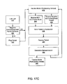
- FIGS. 17A-D and FIGS. 18A-B collectively illustrate methods for communicating between elements, that is participating vehicles and egress points, in the hierarchical floating car data network.
- FIG. 17A shows an infrastructure mode packet transmitting method for a participating vehicle. If a beacon timer has expired 258 a beacon service table or a vehicle service table is created 260 . Concurrently, if the volume of local data exceeds a memory threshold 262 , the application module creates a packet burst 264 .
- the packet burst comprises information for the on-board equipment storage and is ready to be transmitted as soon as the vehicle establishes communication with an egress point or other participating vehicles.
- the packet burst has a variable size of several kilobytes.
- the packet burst or beacon service table packet or the vehicle service table packet is sent to the radio 266 .
- the packet burst reaches the radio layer 266 , it is fragmented using the packet length rules described above and then encapsulated in a regular IEEE 802.11 data packet format.
- a train of packet fragments is sequentially transmitted as defined in the IEEE 802.11 standard.
- a packet burst can preemptively occur even if a BST or VST is queued for transmission 268 .
- the application broadcasts BST and VST packets in the same manner as described for the baseline radio in U.S. patent application Ser. No. 10/272,039. Additionally, the application broadcasts packet bursts along with the BST and VST packets.
- a participating vehicle that broadcasts packet bursts can purge data packets from its storage area if at least one other participating vehicle has acknowledged the reception and custody of the packet burst.
- FIG. 17D shows an infrastructure mode packet transmitting method for an egress point.
- An egress point transmission sequence begins when an enhanced beacon timer expires 310 , or when a the reception of a packet burst is rejected 290 . Rejected packet bursts will be described with reference to FIG. 17 B.
- An enhanced beacon packet 314 is created when the enhanced beacon timer expirees 310 , or a negative acknowledgment packet 316 is created if the packet burst is rejected ( 288 of FIG. 17 B).
- the enhanced beacon packet or the negative acknowledgement packet is sent to the radio 318 .
- the packet at the radio is queued 320 which includes applying a priority scheme.
- the queued packet is transmitted 322 when the communication medium is idle, and the radio returns to the default receive mode 274 .
- the application running at the egress point does not provide positive acknowledgements for performance reasons.
- the packet burst is retransmitted after a randomly chosen backoff interval or the retransmission is deferred until another egress point is within range. This decision 302 is depends on the reason for the failure to receive the packets as specified in the negative acknowledgement. If an immediate retransmission is determined a transition to the transmit mode occurs 306 . If transmission is not necessary the radio transitions to the default receive mode 272 .
- FIG. 17B shows an infrastructure mode packet receiving method for an egress point.
- the egress point receives a beacon service table or vehicle service table packet 276 , or a packet burst 278 from a participating vehicle.
- the packet 276 or 278 is sent to the application 280 where it is either accepted 282 or rejected 288 .
- the packet is rejected 288 if a memory threshold is exceeded 286 . If the packet is accepted the egress point radio remains in the default receiving mode 274 , otherwise a transition occurs to the transmit mode 290 whereby a negative acknowledgement packet is created and transmitted to the participating vehicle as described above.
- FIGS. 18A-B show ad-hoc mode packet transmitting and receiving methods between participating vehicles.
- the amount of time that two or more participating vehicles can communicate within varies from very small in the case of vehicles traveling at high speeds in opposite directions, to very large for vehicles moving in the same direction at substantially equal speeds.
- all packet exchange is unacknowledged at the media access controller (MAC) layer.
- the application at the receiving vehicle generates a positive acknowledgement packet after a randomly chosen time offset to indicate that the receiving vehicle has taken custody of the received packet.
- a timer at each participating vehicle is randomly set. Any participating vehicle that receives a packet from another participating vehicle before its randomly set timer expires does not transmit the positive acknowledgement.
- positive acknowledgement packet transmissions from multiple participating vehicles are reduced since only a few positive acknowledgements are transmitted before all participating vehicles within range reset their timers.
- positive acknowledgements may be transmitted from only those participating vehicles with stable, high quality communication links.
- current location and trajectory may be used to determine which participating vehicles should issue positive acknowledgements.
- the decision to accept 360 , or take custody of the packet burst, or reject 358 the packet burst is based on the amount of resources available at the participating vehicle as well as its trajectory and connectivity.
- the first vehicle transmits some of its data to the second vehicle.
- the trajectory of a participating vehicle is considered in ascertaining whether to assume custody of data from other participating vehicles. If a participating vehicle is moving towards an egress point, then accumulated data can be uploaded to a higher layer of the hierarchical floating car data network, and from there to other participating vehicles. In this way, a participating vehicle acts as a mobile router, transferring data from other participating vehicles to an egress point.
- a participating vehicle that has WWAN capabilities can transmit data received in the ad-hoc mode from other participating vehicles directly to the central server. From the central server, the data can be transmitted to egress points and participating vehicles.
- FIG. 19 illustrates two participating vehicles sharing route information.
- a participating vehicle 384 requests routing directions.
- the participating vehicle 384 broadcasts a BST/VST beacon packet.
- the beacon packet includes a flag that signals a request for routing directions to a destination of the transmitting vehicle 384 .
- the transmitting vehicle 384 may or may not be carrying an on-board geographic database.
- the egress point When the beacon packet is received by an egress point 382 , the egress point obtains routing instructions from its regional database. If there is no regional database at the egress point, as may be the case with a mobile egress point, turn-by-turn directions can be obtained from previously collected traces received by the egress point from other participating vehicles. Also, the egress point can forward the routing request to another egress point that has a regional database, or the routing request can be forwarded to the central database.
- Another participating vehicle within range may also receive the beacon and respond with a packet comprising a series of routing instructions to the destination.
- the response packet can be constructed from a query of the local database of the participating vehicle that received the beacon, or from a destination approximation algorithm.
- a participating vehicle 386 that originated from a location nearby the requested destination may return its complete trace in inverse order as a routing aid to a requesting vehicle 388 . This may be useful in obtaining at least partial instructions until another participating vehicle can provide further assistance.
- a participating vehicle requesting or receiving a request for directions has only a street name in its database but no data to produce turn-by-turn directions
- the vehicle derives the coordinates of the destination using an on-board reverse-geocoding application process. Using those coordinates, a surrounding minimum bounding rectangle serves as the designated destination. If another participating vehicle within range has any kind of overlap routing information within the designated destination, then a packet comprising the routing information is transmitted back to the requesting vehicle to facilitate routing decisions. The amount of overlap, or the distance between the destination and the closest geographic location from the received routing information, is compared against a threshold to determine its relevance.
- rx_packet state 256 when a packet is received a transition from either the on state 248 or the off sate 250 to the rx_packet state 256 occurs.
- the packet contents such as BST and VST data, are extracted, processed, analyzed and stored.
- a self-interrupt causes a transition from the rx_state 256 to the sensor state 246 for further processing as shown by the “NEW_SAMPLE” transition arrow.
- the database state 242 comprises a hash table with data available from U.S. Census sources, along with a query-response interface for input/output.
- the database state 242 comprises direct system calls to commercially available geographic databases. The data available in the database state 242 can be accessed by all other states in the application.
- the egress point software of FIG. 6 and the on-board software of FIG. 8 include a geographic database 96 , 124 respectively.
- Geographic databases have many different formats.
- the geographic database is referred to as a local database.
- the local database comprises a compressed, limited data set that covers particular areas of interest or travel.
- the geographic database is referred to as a regional database, or an egress point database.
- the egress point database comprises a data set of the region covered by the egress point.
- the egress point database may also comprise data on additional regions outside the range of the egress point if the egress point equipment has sufficient memory and storage.
- the central server comprises the central database, which comprises data of all regions.
- FIG. 16 shows a method for updating a database implemented by the database state 242 .
- the area of interest on which the database update is going to occur is defined 374 using a bounding rectangle to define an area database.
- the area database is loaded into memory 376 .
- a database in a participating vehicle does not necessary have all the cartographic details due to the different approach described previously in organizing content based on the needs of the individual end user and not the geographic region. In such a case, the participating vehicle attempts to pass the information up to an egress point or a mobile egress point.
- An egress point also operates on a database using dynamic content from the hierarchical floating car data network. At the same time more details can be retrieved and integrated as need arises.
- an egress point may load into memory more data describing a road segment that was not received from participating vehicles. In this way, the egress point is able to expand the detail of the database and simultaneously assess if the new received data results a database update or some other event. In some cases, the egress point may not be able to assess if an update is needed, or the egress point might not be able to locally retrieve information that can be associated with the received report from a participating vehicle. In such a case, the egress point contacts the central server where a database with all details is maintained along with a database comprising content from only the network.
- a shape algorithm is applied 378 to generate the geometric representation of present map features such as lines, polylines, curves, rectangles, polygons and the like.
- control points are derived 389 that are used to represent complex features generated from the shape algorithm 378 .
- Pivotal data is continuously loaded 368 from the on-board sensor modules and additional context 370 is derived.
- additional context is generated to classify content based on the end user's preferences and behavior. If additional context is available, it is used to determine the area of interest 374 based not only on the current location of the participating vehicle but also on the features that are most likely to be used from the end user driving the vehicle.
- a pattern matching algorithm 372 is used to compare, validate, and integrate the information available.
- Many pattern matching algorithms may be used. Some examples include maximum likelihood estimation, Bayesian estimation, discriminant functions, neural networks and machine learning.
- the state machine Upon completion of the database update, the state machine returns to the sensor state 246 and then back to the state that caused the transition to the sensor state 246 .
- roads are classified based on the amount of detail they provide. For example, in one database, four levels of detail are used. At level 1, major interstate freeways are included. At level 2, interstates, highways, and expressways are included. At level 3, interstates, highways, expressways, and main residential streets are included. At level 4, all available roads are included. Turn-by-turn routing algorithms use the layered structure of the database road representation to expedite the process of discovering the route to the destination. A common approach includes, after setting the origin and destination points, applying routing at the highest level for areas nearby the origin-destination points, and for the remaining uncovered areas, applying routing search algorithms using road detail information available at level 2.
- FIG. 14 shows traces from a plurality of participating vehicles traveling a network of roads.
- Most of the vehicle traces 218 , 220 , 222 , 226 , 228 , 230 , 234 , 236 , and 238 correspond to road information of the database.
- the portion of traces indicated by region 240 does not correspond with the roads of the database.
- a piecewise Rubber-Sheet transformation and ward point triangulation comparisons can be performed to adjust the database. These calculations can be performed on the local database of a participating vehicle, at a database at an egress point, or at the database at the central server.
- traces from participating vehicles may correspond to off-road routes and not a new road or an additional lane.
- a driver may drive through a gas station to avoid a traffic light at an intersection. That route should not be considered as an indication that the intersection has changed.
- the trace of a vehicle using a bike lane or the emergency lane should not be considered as an indication of a new available lane.
- overlapping areas such as bridges, overpasses, and tunnels should not be considered intersections.
- Trend analysis of the samples is used to avoid situations such as these. Trend analysis is based on linear regression equations. Many other techniques may be used.
- Errors can also be produced when calculating average flow speed for road segments comprising both carpool lanes and regular lanes.
- a carpool lane, or high occupancy vehicle (HOV) lane is reserved for use by vehicle carrying more than one passenger.
- HOV high occupancy vehicle
- some vehicles will appear to be moving much faster than other vehicles, producing an artificially high average flow speed.
- the error can be reduced since a much larger proportion of vehicles travel on non-HOV lanes over during a period of time. For example, if 75% of participating vehicles are not in the HOV lane then using the median of all readings for a road segment leads to a number much closer to the realistic flow speed.
- using the relative location of participating vehicle along with speed can also provide accurate results. For example, a participating vehicle with a trace that appears on average to be on the 10% of the leftmost traces previously accumulated for a road segment is very likely to be using an HOV lane. This is further the case if the vehicle is moving at a much higher average flow speed than vehicles with traces on the rest of the road segment.
- GDF Geographic Data File
- CEN International Standards Organization
- SDTS Spatial Data Transfer Standard
- openGIS Open GIS Consortium
- Many methods and systems may be used to form the geographic databases from sensor data from the participating vehicles as they travel the transportation network such as the method and system of U.S. Pat. No. 5,953,722, which is hereby incorporated by reference.
- the structure of the geographic database supports methods to search and identify objects of interest.
- An object of interest comprises unique database semantic identifiers and enhanced characteristics to facilitate interpretation of database entries.
- a node, edge, point, line, area, federal information processing standards (FIPS), relationship, source document, and a name are objects of interest.
- a set of nodes or edges, X/Y/Z values, attributes, text of a name, geometric composition, and any descriptive information are characteristics.
- a sub-attribute may be used with a characteristic to define a limitation for an object. When a characteristic is associated with an object it is given a value.
- a database object can be identified by either an explicit reference when a unique identifier is available, or by a descriptive reference when a portion of the characteristic data forms the database query.
- the database publisher is responsible for defining the reference applicable to a database object, the format of the references, and the fields that comprise a reference.
- An incremental update is for updating old data with current data.
- An insert or delete update is for inserting new information or deleting old information. For example, a change in the allowable traffic direction is an incremental update, whereas a new street entity (name and direction) is an insertion update. All updates are accompanied by control metadata that ensures the integrity of the database before and after the update. As an update is processed, the database transitions between valid states and always maintains a valid fallback state in case of database instabilities.
- An update identifier is a number that uniquely identifies the updating process. Since many participating vehicles and egress points can generate database updates, an update identifier comprises two fields: a unique participating vehicle or egress point identifier, and a wrap-around sequentially increasing integer which is based on the number of updates produced from the same source.
- the update identifier also comprises a dependency field, a database identification fields, a timestamp, and a number of actions field.
- the dependency field is a set of update identifiers that must be successfully completed prior to the current update.
- the database identification field is the identifier of the database being updated.
- the timestamp is the time period during which the update information became available.
- the number of actions field is the number of updates requested from the source of the additional information, that is the participating vehicle or egress point.
- the update identifier also comprises the database actions.
- the database actions comprise a detailed description of the nature of the update to be performed.
- the types of actions are: add and object, delete and object, add a characteristic, delete a characteristic, and modify a characteristic.
- An action comprises the fields: a credibility factor that comprises the statistical sample collected before the update was generated, an object reference that provides a pointer to an object, an old data state and a new data state comprising the old and new contents of the object. The contents of the old data state and the new data state change according to the type of the action that is required.
- An action is performed if the statistical sample described by the credibility control field exceeds a threshold. If there is no strong statistical evidence to apply an update, the action is discarded. Calibration using past results can take place to adjust the credibility factor if it appears to be too high to too low.
- the geographic database and the updates can be represented in different formats.
- a wrapper may be used to translate a proprietary database format to a non-proprietary database format, incorporate the new updates, and then translate the resultant database to its original proprietary format.
- a metadata table can be used to translate data from a future version database to a database in use by a participating vehicle. If a metadata table cannot provide the necessary version translation, replacement routines are used.
- a replacement routine replaces native code from the interface layer, or a navigation application. To speed up execution of the replacement routine they may be compiled to an interpreted, machine independent format. Portions of the metadata engine may be written in a Java virtual machine (JVM) environment. If memory is limited, replacement functions may be loaded into memory during initialization or during run-time as needed.
- JVM Java virtual machine
- compression methods utilizing data represented as deltas can be used, such as in U.S. Pat. No. 6,460,046, which is hereby incorporated by reference. Curve fitting methods, linear approximation, and other methods can also be used. Huffman coding may be used, where Huffman trees can be created that correspond to different information layers of the database, such as in U.S. Pat. No. 6,393,149 which is hereby incorporated by reference. If processing requirement for compression and decompression are high, thereby causing processing bottlenecks, less efficient compression techniques may be used. Scaling methods may be used to select sample points along new or modified trajectories in much the same way a variable segment length describes a complex line.
Abstract
Description
Claims (31)
Priority Applications (3)
| Application Number | Priority Date | Filing Date | Title |
|---|---|---|---|
| US10/437,205 US6925378B2 (en) | 2003-05-12 | 2003-05-12 | Enhanced mobile communication device with extended radio, and applications |
| EP04760970.6A EP1631790B1 (en) | 2003-05-12 | 2004-05-11 | Enhanced mobile communication method and corresponding device with extended radio |
| PCT/US2004/014583 WO2004102986A2 (en) | 2003-05-12 | 2004-05-11 | Enhanced mobile communication device with extended radio, and applications |
Applications Claiming Priority (1)
| Application Number | Priority Date | Filing Date | Title |
|---|---|---|---|
| US10/437,205 US6925378B2 (en) | 2003-05-12 | 2003-05-12 | Enhanced mobile communication device with extended radio, and applications |
Publications (2)
| Publication Number | Publication Date |
|---|---|
| US20040230370A1 US20040230370A1 (en) | 2004-11-18 |
| US6925378B2 true US6925378B2 (en) | 2005-08-02 |
Family
ID=33417327
Family Applications (1)
| Application Number | Title | Priority Date | Filing Date |
|---|---|---|---|
| US10/437,205 Expired - Lifetime US6925378B2 (en) | 2003-05-12 | 2003-05-12 | Enhanced mobile communication device with extended radio, and applications |
Country Status (3)
| Country | Link |
|---|---|
| US (1) | US6925378B2 (en) |
| EP (1) | EP1631790B1 (en) |
| WO (1) | WO2004102986A2 (en) |
Cited By (82)
| Publication number | Priority date | Publication date | Assignee | Title |
|---|---|---|---|---|
| US20040063458A1 (en) * | 2002-10-01 | 2004-04-01 | Masato Hori | Wireless LAN communication system |
| US20040203461A1 (en) * | 2002-11-13 | 2004-10-14 | General Motors Corporation | Method and system for providing GPS interference information from a civilian mobile vehicle communications system |
| US20040230373A1 (en) * | 2003-05-12 | 2004-11-18 | Assimakis Tzamaloukas | Hierarchical floating car data network |
| US20040258011A1 (en) * | 2003-01-30 | 2004-12-23 | Ntt Docomo, Inc. | Mobile communication system, location manager and routing manager |
| US20050064895A1 (en) * | 2003-09-22 | 2005-03-24 | General Motors Corporation | Method and system for operating a degraded vehicle communication unit |
| US20050076137A1 (en) * | 2003-09-19 | 2005-04-07 | Chungtang Tang | Utilizing proximity information in an overlay network |
| US20050131627A1 (en) * | 2003-12-15 | 2005-06-16 | Gary Ignatin | Traffic management in a roadway travel data exchange network |
| US20050131629A1 (en) * | 2003-12-15 | 2005-06-16 | Ignatin Gary R. | Roadway travel data exchange network |
| US20050203677A1 (en) * | 2004-03-08 | 2005-09-15 | Jean-Laurent Auger | Method for guiding in real time a landborne vehicle provided with an off-board navigation system |
| US20050215200A1 (en) * | 2004-03-25 | 2005-09-29 | General Motors Corporation | Method and system for implementing a vehicle WiFi access point gateway |
| US20060050729A1 (en) * | 2004-09-08 | 2006-03-09 | Paul Chen | Wireless state machine and multiplexing method for concurrent ad-hoc and infrastructure mode service in wireless networking |
| US20060178807A1 (en) * | 2004-09-10 | 2006-08-10 | Xanavi Informatics Corporation | Apparatus and method for processing and displaying traffic information in an automotive navigation system |
| US20060183487A1 (en) * | 2005-02-15 | 2006-08-17 | @Road, Inc. | Method for locating coverage gaps in wireless communication services |
| US20060190164A1 (en) * | 2005-02-23 | 2006-08-24 | General Motors Corporation | Method for transferring routes between navigational devices |
| US20060265125A1 (en) * | 2005-05-23 | 2006-11-23 | General Motors Corporation | Method and system for selecting route guidance data for off-board navigation |
| US20060268902A1 (en) * | 2005-05-24 | 2006-11-30 | Cingular Wireless Ii, Llc | Dynamic dual-mode service access control, location-based billing, and e911 mechanisms |
| US20060270415A1 (en) * | 2005-05-24 | 2006-11-30 | Intel Corporation | Direct link establishment in wireless networks |
| US20060271283A1 (en) * | 2005-05-26 | 2006-11-30 | General Motors Corporation | System and method for zone based initial route guidance within a telematics equipped mobile vehicle |
| US20070008885A1 (en) * | 2005-05-24 | 2007-01-11 | Cingular Wireless Llc | Dynamic dual-mode service access control, location-based billing, and E911 mechanisms |
| US20070027625A1 (en) * | 2005-07-28 | 2007-02-01 | General Motors Corporation | Method and system for provisioning turn-by-turn navigation demonstrations |
| US20070027614A1 (en) * | 2005-08-01 | 2007-02-01 | General Motors Corporation | Method and system for linked vehicle navigation |
| US20070030857A1 (en) * | 2005-08-02 | 2007-02-08 | Fulknier John C | Mobile router device |
| US20070152844A1 (en) * | 2006-01-03 | 2007-07-05 | Hartley Joel S | Traffic condition monitoring devices and methods |
| US20070156759A1 (en) * | 2005-12-15 | 2007-07-05 | Minoru Sekine | Map data update method and navigation apparatus |
| US20070218891A1 (en) * | 2006-03-16 | 2007-09-20 | Cox Marc S | Navigation System for Portable Communication Devices |
| US20070271079A1 (en) * | 2006-05-17 | 2007-11-22 | Kentaro Oguchi | Simulator for Vehicle Radio Propagation Including Shadowing Effects |
| US20080010011A1 (en) * | 2006-07-07 | 2008-01-10 | General Motors Corporation | Method for storing off-board navigation destination locations |
| US20080027605A1 (en) * | 2005-12-31 | 2008-01-31 | General Motors Corporation | In-vehicle notification of failed message delivery |
| US20080082562A1 (en) * | 2004-11-04 | 2008-04-03 | Rooney Sean G | System and method for tracking notifications in a publish subscribe system |
| US20080086240A1 (en) * | 1995-06-07 | 2008-04-10 | Automotive Technologies International, Inc. | Vehicle Computer Design and Use Techniques |
| US20080091352A1 (en) * | 2006-10-11 | 2008-04-17 | O'hare James K | Automobile collision avoidance system |
| US20080240506A1 (en) * | 2007-03-30 | 2008-10-02 | Aisin Aw Co., Ltd. | Feature information management apparatuses, methods, and programs |
| US20080243312A1 (en) * | 2007-03-30 | 2008-10-02 | Aisin Aw Co., Ltd. | Vehicle behavior learning apparatuses, methods, and programs |
| US20080253615A1 (en) * | 2004-07-09 | 2008-10-16 | Aisin Aw Co., Ltd. | Method of producing traffic signal information, method of providing traffic signal information, and navigation apparatus |
| US20080274752A1 (en) * | 2005-02-03 | 2008-11-06 | Cyril Houri | Method and System for Location-Based Monitoring of a Mobile Device |
| US20080299927A1 (en) * | 2007-05-31 | 2008-12-04 | Motorola, Inc. | Signal strength indication methods for use in wireless communication devices |
| US20090005972A1 (en) * | 2007-06-29 | 2009-01-01 | De Koning Wilhelmus G | Systems and Methods for Determining Location Using Cellular Transition Patterns |
| US20090024312A1 (en) * | 2007-07-18 | 2009-01-22 | Honeywell International Inc. | Method and system for updating navigation information |
| US20090023389A1 (en) * | 2007-07-18 | 2009-01-22 | Broadcom Corporation | System and method for remotely controlling bluetooth enabled electronic equipment |
| US20090088959A1 (en) * | 2007-09-28 | 2009-04-02 | Aisin Aw Co., Ltd. | Parking support systems, parking support methods, and parking support programs |
| US20090143961A1 (en) * | 2007-10-29 | 2009-06-04 | Magneti Marelli Powertrain S.P.A. | Road vehicle control method |
| US20090181658A1 (en) * | 2008-01-15 | 2009-07-16 | West Corporation | System, apparatus and method for availing a mobile call of caller name information |
| US7624376B1 (en) * | 2004-04-08 | 2009-11-24 | Sprint Communications Company L.P. | Integration of COTS software data stores into integrated data access layer |
| US20090298492A1 (en) * | 2008-06-02 | 2009-12-03 | West Corporation | System, apparatus and method for availing a mobile call of address information |
| US20100014420A1 (en) * | 2008-07-21 | 2010-01-21 | Jia Wang | Lightweight Application Classification for Network Management |
| US20100056100A1 (en) * | 2008-09-04 | 2010-03-04 | Microsoft Corporation | Rules-based association of a phone number with one or more destination locations |
| DE102009046276A1 (en) | 2008-11-06 | 2010-05-12 | Ford Global Technologies, LLC, Dearborn | System and method for determining a collision status of a vehicle |
| DE102009046294A1 (en) | 2008-11-06 | 2010-05-12 | Ford Global Technologies, LLC, Dearborn | A system and method for determining a side impact collision status of a vehicle |
| US20100169009A1 (en) * | 1997-10-22 | 2010-07-01 | Intelligent Technologies International, Inc. | Accident Avoidance System |
| US20100178872A1 (en) * | 2009-01-13 | 2010-07-15 | Gm Global Technology Operations, Inc. | Initiating wireless communication between a vehicle and an access point |
| CN101373559B (en) * | 2007-08-24 | 2010-08-18 | 同济大学 | Method for evaluating city road net traffic state based on floating vehicle data |
| US20110057830A1 (en) * | 2009-09-10 | 2011-03-10 | The Boeing Company | Method for validating aircraft traffic control data |
| US20110112766A1 (en) * | 2008-07-16 | 2011-05-12 | Autotalks Ltd. | Relative vehicular positioning using vehicular communications |
| US7949463B2 (en) * | 2003-12-15 | 2011-05-24 | Gary Ignatin | Information filtering and processing in a roadway travel data exchange network |
| US20110237275A1 (en) * | 2010-03-29 | 2011-09-29 | Fujitsu Limited | Portable mobile terminal and computer readable medium |
| US20110320111A1 (en) * | 2010-06-23 | 2011-12-29 | Massachusetts Institute Of Technolgoy | System and method for providing road condition and congestion monitoring using smart messages |
| US8271190B2 (en) | 2004-11-30 | 2012-09-18 | Dash Navigation Inc. | Methods and system for deducing road geometry and connectivity |
| US20120309427A1 (en) * | 2003-04-03 | 2012-12-06 | Network Security Technologies, Inc. | Method and system for locating a wireless access device in a wireless network |
| US8359300B1 (en) * | 2007-04-03 | 2013-01-22 | Google Inc. | System and method for displaying both localized search results and internet search results |
| US8385964B2 (en) | 2005-04-04 | 2013-02-26 | Xone, Inc. | Methods and apparatuses for geospatial-based sharing of information by multiple devices |
| US20130110454A1 (en) * | 2011-10-28 | 2013-05-02 | Microsoft Corporation | Multi-stage dead reckoning for crowd sourcing |
| US8452771B2 (en) | 2011-01-03 | 2013-05-28 | Honda Motor Co., Ltd. | Method for differentiating traffic data obtained from probe vehicles |
| US8565788B2 (en) | 2005-02-03 | 2013-10-22 | Mexens Intellectual Property Holding Llc | Method and system for obtaining location of a mobile device |
| US8892517B2 (en) | 2006-06-09 | 2014-11-18 | Aisin Aw Co., Ltd. | Data updating system, navigation device, server, and method of data updating |
| US8965677B2 (en) | 1998-10-22 | 2015-02-24 | Intelligent Technologies International, Inc. | Intra-vehicle information conveyance system and method |
| US9113391B2 (en) | 2012-06-29 | 2015-08-18 | Microsoft Technology Licensing, Llc | Determining network availability based on geographical location |
| US9137746B2 (en) | 2012-06-29 | 2015-09-15 | Microsoft Technology Licensing, Llc | Determining availability of an access network |
| US20150308835A1 (en) * | 2013-01-11 | 2015-10-29 | Intermec Ip Corp. | Systems, methods, and apparatus to determine physical location and routing within a field of low power beacons |
| US9191420B2 (en) | 2003-07-28 | 2015-11-17 | Microsoft Technology Licensing, Llc | Mobility in a multi-access communication network |
| US9429657B2 (en) | 2011-12-14 | 2016-08-30 | Microsoft Technology Licensing, Llc | Power efficient activation of a device movement sensor module |
| US9439042B2 (en) | 2012-06-29 | 2016-09-06 | Microsoft Technology Licensing, Llc | Determining suitability of an access network |
| US9464903B2 (en) | 2011-07-14 | 2016-10-11 | Microsoft Technology Licensing, Llc | Crowd sourcing based on dead reckoning |
| US9470529B2 (en) | 2011-07-14 | 2016-10-18 | Microsoft Technology Licensing, Llc | Activating and deactivating sensors for dead reckoning |
| US9723520B1 (en) | 2005-12-20 | 2017-08-01 | Microsoft Technology Licensing, Llc | Location based mode switching for dual mode mobile terminals |
| US9817125B2 (en) | 2012-09-07 | 2017-11-14 | Microsoft Technology Licensing, Llc | Estimating and predicting structures proximate to a mobile device |
| US9832749B2 (en) | 2011-06-03 | 2017-11-28 | Microsoft Technology Licensing, Llc | Low accuracy positional data by detecting improbable samples |
| US9954952B2 (en) | 2013-10-31 | 2018-04-24 | International Business Machines Corporation | Data transmission for an internet of vehicles system |
| US20180324876A1 (en) * | 2015-11-19 | 2018-11-08 | Sony Corporation | Device and method |
| US10200371B2 (en) | 2015-11-09 | 2019-02-05 | Silvercar, Inc. | Vehicle access systems and methods |
| US10309787B2 (en) * | 2016-11-10 | 2019-06-04 | Sap Se | Automatic movement and activity tracking |
| US11047701B2 (en) | 2004-11-30 | 2021-06-29 | Blackberry Corporation | User interface system and method for a vehicle navigation device |
| US20220030383A1 (en) * | 2020-07-27 | 2022-01-27 | Honda Motor Co., Ltd. | Vehicle control system and vehicle control method |
Families Citing this family (114)
| Publication number | Priority date | Publication date | Assignee | Title |
|---|---|---|---|---|
| JP2005033345A (en) * | 2003-07-09 | 2005-02-03 | Allied Telesis Holdings Kk | Communication system and its method |
| JP4349253B2 (en) * | 2004-02-17 | 2009-10-21 | 株式会社デンソー | Lending support system, communication device, server |
| EP1810453A4 (en) * | 2004-11-12 | 2011-08-24 | Nanoradio Ab | A wlan station and a method of operating the station in infrastructure mode and in independent (ad-hoc) mode simultaneously. |
| US20060104235A1 (en) * | 2004-11-12 | 2006-05-18 | Orjan Fritz | Mixed mode wireless local area network terminal |
| US20060161315A1 (en) * | 2004-11-22 | 2006-07-20 | Ron Lewis | Vehicle position and performance tracking system using wireless communication |
| CN100477851C (en) * | 2005-01-05 | 2009-04-08 | 国际商业机器公司 | Method and system for carrying out switching between two communication modes of WLAN |
| US20060166644A1 (en) * | 2005-01-25 | 2006-07-27 | Champion Mark A | Distributed GPS traffic information system |
| US7397424B2 (en) * | 2005-02-03 | 2008-07-08 | Mexens Intellectual Property Holding, Llc | System and method for enabling continuous geographic location estimation for wireless computing devices |
| DE112006000618T5 (en) | 2005-03-15 | 2008-02-07 | Trapeze Networks, Inc., Pleasanton | System and method for distributing keys in a wireless network |
| CA2891641C (en) | 2005-03-18 | 2018-01-02 | Gatekeeper Systems, Inc. | Navigation systems and methods for wheeled objects |
| TWI269561B (en) * | 2005-04-13 | 2006-12-21 | Mitac Int Corp | System and method for dynamically receiving the packet of an assisted global positioning system (AGPS) |
| US9189895B2 (en) | 2005-06-01 | 2015-11-17 | Allstate Insurance Company | Motor vehicle operating data collection and analysis |
| KR100749226B1 (en) * | 2005-07-26 | 2007-08-13 | 주식회사 현대오토넷 | Apparatus and method for deciding traveling direction of navigation system |
| WO2007044986A2 (en) | 2005-10-13 | 2007-04-19 | Trapeze Networks, Inc. | System and method for remote monitoring in a wireless network |
| US8638762B2 (en) | 2005-10-13 | 2014-01-28 | Trapeze Networks, Inc. | System and method for network integrity |
| US7724703B2 (en) | 2005-10-13 | 2010-05-25 | Belden, Inc. | System and method for wireless network monitoring |
| US7551619B2 (en) | 2005-10-13 | 2009-06-23 | Trapeze Networks, Inc. | Identity-based networking |
| US7573859B2 (en) | 2005-10-13 | 2009-08-11 | Trapeze Networks, Inc. | System and method for remote monitoring in a wireless network |
| US8250587B2 (en) | 2005-10-27 | 2012-08-21 | Trapeze Networks, Inc. | Non-persistent and persistent information setting method and system for inter-process communication |
| US20070106778A1 (en) * | 2005-10-27 | 2007-05-10 | Zeldin Paul E | Information and status and statistics messaging method and system for inter-process communication |
| US7706963B2 (en) * | 2005-10-28 | 2010-04-27 | Gm Global Technology Operations, Inc. | System for and method of updating traffic data using probe vehicles having exterior sensors |
| US20070150138A1 (en) | 2005-12-08 | 2007-06-28 | James Plante | Memory management in event recording systems |
| US10878646B2 (en) | 2005-12-08 | 2020-12-29 | Smartdrive Systems, Inc. | Vehicle event recorder systems |
| JP2007166000A (en) * | 2005-12-09 | 2007-06-28 | Fujitsu Ltd | Channel assignment method by wireless base station group, and wireless system |
| US7596109B1 (en) * | 2005-12-16 | 2009-09-29 | Airmagnet, Inc. | Disrupting an ad-hoc wireless network |
| US8374777B2 (en) * | 2005-12-19 | 2013-02-12 | International Business Machines Corporation | GPS equipped devices that utilize geographical navigation bundles |
| US9201842B2 (en) | 2006-03-16 | 2015-12-01 | Smartdrive Systems, Inc. | Vehicle event recorder systems and networks having integrated cellular wireless communications systems |
| US8996240B2 (en) | 2006-03-16 | 2015-03-31 | Smartdrive Systems, Inc. | Vehicle event recorders with integrated web server |
| US9478133B2 (en) | 2006-03-31 | 2016-10-25 | Volkswagen Ag | Motor vehicle and navigation arrangement for a motor vehicle |
| US20070233371A1 (en) | 2006-03-31 | 2007-10-04 | Arne Stoschek | Navigation system for a motor vehicle |
| GB2436909A (en) * | 2006-04-08 | 2007-10-10 | Uws Ventures Ltd | Vehicle telematics system |
| US7558266B2 (en) | 2006-05-03 | 2009-07-07 | Trapeze Networks, Inc. | System and method for restricting network access using forwarding databases |
| US8966018B2 (en) | 2006-05-19 | 2015-02-24 | Trapeze Networks, Inc. | Automated network device configuration and network deployment |
| US7912982B2 (en) | 2006-06-09 | 2011-03-22 | Trapeze Networks, Inc. | Wireless routing selection system and method |
| US9191799B2 (en) | 2006-06-09 | 2015-11-17 | Juniper Networks, Inc. | Sharing data between wireless switches system and method |
| US8818322B2 (en) | 2006-06-09 | 2014-08-26 | Trapeze Networks, Inc. | Untethered access point mesh system and method |
| US9258702B2 (en) | 2006-06-09 | 2016-02-09 | Trapeze Networks, Inc. | AP-local dynamic switching |
| US7844298B2 (en) | 2006-06-12 | 2010-11-30 | Belden Inc. | Tuned directional antennas |
| US7724704B2 (en) | 2006-07-17 | 2010-05-25 | Beiden Inc. | Wireless VLAN system and method |
| US8612437B2 (en) * | 2006-08-28 | 2013-12-17 | Blackberry Limited | System and method for location-based searches and advertising |
| US8340110B2 (en) | 2006-09-15 | 2012-12-25 | Trapeze Networks, Inc. | Quality of service provisioning for wireless networks |
| US8339990B1 (en) * | 2006-09-23 | 2012-12-25 | Dash Navigation, Inc. | System and method for matching capabilities of access points with those required by an application |
| US8072952B2 (en) | 2006-10-16 | 2011-12-06 | Juniper Networks, Inc. | Load balancing |
| US8989959B2 (en) | 2006-11-07 | 2015-03-24 | Smartdrive Systems, Inc. | Vehicle operator performance history recording, scoring and reporting systems |
| US8649933B2 (en) | 2006-11-07 | 2014-02-11 | Smartdrive Systems Inc. | Power management systems for automotive video event recorders |
| US8868288B2 (en) | 2006-11-09 | 2014-10-21 | Smartdrive Systems, Inc. | Vehicle exception event management systems |
| KR101151815B1 (en) * | 2006-11-17 | 2012-06-01 | 한국전자통신연구원 | Apparatus and method for position transmission and identification using close range communication |
| US7873061B2 (en) | 2006-12-28 | 2011-01-18 | Trapeze Networks, Inc. | System and method for aggregation and queuing in a wireless network |
| US7385150B1 (en) | 2006-12-28 | 2008-06-10 | Microsoft Corporation | Sliding mechanism for device with two keyboards |
| US7865713B2 (en) | 2006-12-28 | 2011-01-04 | Trapeze Networks, Inc. | Application-aware wireless network system and method |
| JP4872705B2 (en) * | 2007-02-20 | 2012-02-08 | 日本電気株式会社 | COMMUNICATION SYSTEM, COMMUNICATION METHOD, AND PROGRAM THEREOF |
| US8239092B2 (en) | 2007-05-08 | 2012-08-07 | Smartdrive Systems Inc. | Distributed vehicle event recorder systems having a portable memory data transfer system |
| DE102007042793A1 (en) * | 2007-09-07 | 2009-03-12 | Bayerische Motoren Werke Aktiengesellschaft | Method for providing driving operation data |
| US8902904B2 (en) | 2007-09-07 | 2014-12-02 | Trapeze Networks, Inc. | Network assignment based on priority |
| US8509128B2 (en) | 2007-09-18 | 2013-08-13 | Trapeze Networks, Inc. | High level instruction convergence function |
| US8238942B2 (en) | 2007-11-21 | 2012-08-07 | Trapeze Networks, Inc. | Wireless station location detection |
| JP4987760B2 (en) * | 2008-03-05 | 2012-07-25 | 株式会社オートネットワーク技術研究所 | Relay device, communication system, and communication method |
| US8150357B2 (en) | 2008-03-28 | 2012-04-03 | Trapeze Networks, Inc. | Smoothing filter for irregular update intervals |
| US8474023B2 (en) | 2008-05-30 | 2013-06-25 | Juniper Networks, Inc. | Proactive credential caching |
| US8978105B2 (en) | 2008-07-25 | 2015-03-10 | Trapeze Networks, Inc. | Affirming network relationships and resource access via related networks |
| US8238298B2 (en) | 2008-08-29 | 2012-08-07 | Trapeze Networks, Inc. | Picking an optimal channel for an access point in a wireless network |
| US8515654B2 (en) | 2008-09-23 | 2013-08-20 | Microsoft Corporation | Mobile data flow collection and dissemination |
| GB0822893D0 (en) * | 2008-12-16 | 2009-01-21 | Tele Atlas Bv | Advanced speed profiles - Further updates |
| WO2010069380A1 (en) * | 2008-12-18 | 2010-06-24 | Tele Atlas B.V. | Method and apparatus for updating map data |
| US8232898B2 (en) * | 2009-03-31 | 2012-07-31 | GM Global Technology Operations LLC | E85 gas station locator applications using V2X peer-to-peer social networking |
| US8831869B2 (en) * | 2009-03-31 | 2014-09-09 | GM Global Technology Operations LLC | Using V2X-based in-network message generation, aggregation, distribution and processing protocols to enable road hazard condition warning applications |
| US8861492B2 (en) | 2009-04-29 | 2014-10-14 | Samsung Electronics Co., Ltd | Method for communication between a WLAN terminal and a human interface device |
| EP2433096A1 (en) | 2009-05-20 | 2012-03-28 | Continental Teves AG & Co. oHG | Device and method for assigning new data to a digital card |
| DE102010002093B4 (en) * | 2009-06-03 | 2024-03-14 | Continental Automotive Technologies GmbH | C2X communication with reduced data volume |
| JP2011193096A (en) * | 2010-03-12 | 2011-09-29 | Nec Corp | Communication system, communication instrument, and communication method |
| US8676920B2 (en) * | 2010-12-08 | 2014-03-18 | GM Global Technology Operations LLC | Intelligent cache management protocol for vehicular networks |
| US8447804B2 (en) * | 2010-12-21 | 2013-05-21 | GM Global Technology Operations LLC | Information gathering system using multi-radio telematics devices |
| CN102110363B (en) * | 2011-03-30 | 2013-07-10 | 北京世纪高通科技有限公司 | Floating vehicle data processing method and device |
| US9014632B2 (en) * | 2011-04-29 | 2015-04-21 | Here Global B.V. | Obtaining vehicle traffic information using mobile bluetooth detectors |
| US8937903B2 (en) * | 2011-06-14 | 2015-01-20 | At&T Intellectual Property I, L.P. | System and method for providing a content delivery network via a motor vehicle |
| DE102011077952A1 (en) * | 2011-06-22 | 2012-12-27 | Robert Bosch Gmbh | Method for improving route planning of navigation system installed in motor vehicle, involves transmitting additional information from navigation system directly to another navigation system |
| DE102011082571A1 (en) | 2011-09-13 | 2013-03-14 | Robert Bosch Gmbh | Device and method for determining a position of a vehicle |
| US9240079B2 (en) | 2012-04-17 | 2016-01-19 | Lytx, Inc. | Triggering a specialized data collection mode |
| US8676428B2 (en) * | 2012-04-17 | 2014-03-18 | Lytx, Inc. | Server request for downloaded information from a vehicle-based monitor |
| US9728228B2 (en) | 2012-08-10 | 2017-08-08 | Smartdrive Systems, Inc. | Vehicle event playback apparatus and methods |
| CN103052023A (en) * | 2012-11-23 | 2013-04-17 | 中兴通讯股份有限公司 | Method and terminal for acquiring road condition information |
| DE102012222780A1 (en) * | 2012-12-11 | 2014-06-12 | Siemens Aktiengesellschaft | Method for communication within an ad-hoc cooperating, in particular wireless, motor vehicle communication system, installation of the traffic infrastructure and traffic participant device |
| US9097548B2 (en) * | 2013-01-07 | 2015-08-04 | Televav, Inc. | Content delivery system with natural language mechanism and method of operation thereof |
| US8983764B2 (en) | 2013-03-15 | 2015-03-17 | Google Inc. | Dynamic determination of device location reporting frequency |
| DE102013107960B4 (en) * | 2013-07-25 | 2020-11-05 | Deutsches Zentrum für Luft- und Raumfahrt e.V. | Method for updating a database as well as device and computer program |
| US9501878B2 (en) | 2013-10-16 | 2016-11-22 | Smartdrive Systems, Inc. | Vehicle event playback apparatus and methods |
| US9610955B2 (en) | 2013-11-11 | 2017-04-04 | Smartdrive Systems, Inc. | Vehicle fuel consumption monitor and feedback systems |
| US9251630B2 (en) * | 2013-12-17 | 2016-02-02 | At&T Intellectual Property I, L.P. | Method, computer-readable storage device and apparatus for exchanging vehicle information |
| US8892310B1 (en) | 2014-02-21 | 2014-11-18 | Smartdrive Systems, Inc. | System and method to detect execution of driving maneuvers |
| DE102014213984A1 (en) | 2014-07-17 | 2016-01-21 | Continental Automotive Gmbh | Method for providing a service |
| US9663127B2 (en) | 2014-10-28 | 2017-05-30 | Smartdrive Systems, Inc. | Rail vehicle event detection and recording system |
| US11069257B2 (en) | 2014-11-13 | 2021-07-20 | Smartdrive Systems, Inc. | System and method for detecting a vehicle event and generating review criteria |
| DE102014017911B4 (en) | 2014-12-04 | 2020-07-23 | Audi Ag | Provision of road condition data in the motor vehicle |
| US9849882B2 (en) * | 2015-02-06 | 2017-12-26 | Jung H BYUN | Vehicle control based on crowdsourcing data |
| US10096240B2 (en) * | 2015-02-06 | 2018-10-09 | Jung H BYUN | Method and server for traffic signal regulation based on crowdsourcing data |
| CN105991181B (en) * | 2015-02-15 | 2019-03-26 | 深圳市金溢科技股份有限公司 | Path Recognition wireless communications method, mark antenna and mark terminal based on 5.8GHz DSRC |
| IN2015CH01599A (en) | 2015-03-28 | 2015-05-01 | Wipro Ltd | |
| US9679420B2 (en) | 2015-04-01 | 2017-06-13 | Smartdrive Systems, Inc. | Vehicle event recording system and method |
| US9646402B2 (en) | 2015-06-19 | 2017-05-09 | International Business Machines Corporation | Geographic space management |
| DE102016205543A1 (en) * | 2015-11-05 | 2017-05-11 | Continental Teves Ag & Co. Ohg | Method and system for exchanging map data depending on a quality measure |
| DE102015221838B4 (en) * | 2015-11-06 | 2018-03-15 | Pepperl + Fuchs Gmbh | Conveyor |
| DE102015221827B4 (en) * | 2015-11-06 | 2018-03-15 | Pepperl + Fuchs Gmbh | Conveyor |
| US10594806B2 (en) | 2015-12-16 | 2020-03-17 | International Business Machines Corporation | Management of mobile objects and resources |
| US9467839B1 (en) | 2015-12-16 | 2016-10-11 | International Business Machines Corporation | Management of dynamic events and moving objects |
| EP3376249A1 (en) * | 2017-03-17 | 2018-09-19 | Veoneer Sweden AB | Enhanced object position detection |
| CN109945880B (en) * | 2017-12-20 | 2022-11-04 | 华为技术有限公司 | Path planning method, related equipment and readable storage medium |
| CN108200595B (en) * | 2017-12-28 | 2020-08-28 | 长安大学 | Vehicle-road and vehicle-vehicle communication testing method oriented to IEEE802.11p protocol of Internet of vehicles |
| FR3090091B1 (en) * | 2018-12-13 | 2021-03-19 | Continental Automotive France | Production of digital road maps by participatory production |
| CN109714421B (en) * | 2018-12-28 | 2021-08-03 | 国汽(北京)智能网联汽车研究院有限公司 | Intelligent networking automobile operation system based on vehicle-road cooperation |
| CN110213343A (en) * | 2019-05-13 | 2019-09-06 | 上海电机学院 | A kind of car networking system and its application method based on NB-Iot technology and GPS system |
| CN114424264A (en) * | 2019-09-19 | 2022-04-29 | 华为云计算技术有限公司 | Device for synchronizing position information |
| US10999719B1 (en) * | 2019-12-03 | 2021-05-04 | Gm Cruise Holdings Llc | Peer-to-peer autonomous vehicle communication |
| US11694543B2 (en) * | 2020-11-03 | 2023-07-04 | Argo AI, LLC | System and method for data offloading and uploading to exchange data between nodes of a vehicle traffic infrastructure system |
| CN115544147B (en) * | 2022-10-18 | 2023-12-08 | 山东水发紫光大数据有限责任公司 | Machine room data reading method, device, equipment and storage medium |
Citations (34)
| Publication number | Priority date | Publication date | Assignee | Title |
|---|---|---|---|---|
| US4350970A (en) | 1979-11-13 | 1982-09-21 | Siemens Aktiengesellschaft | Method for traffic determination in a routing and information system for individual motor vehicle traffic |
| US5610821A (en) | 1994-11-18 | 1997-03-11 | Ibm Corporation | Optimal and stable route planning system |
| US5732383A (en) | 1995-09-14 | 1998-03-24 | At&T Corp | Traffic information estimation and reporting system |
| US5784005A (en) * | 1994-08-31 | 1998-07-21 | Toyota Jidosha Kabushiki Kaisha | Communications infrasturcture system for vehicles |
| US5953722A (en) | 1996-10-25 | 1999-09-14 | Navigation Technologies Corporation | Method and system for forming and using geographic data |
| US5983161A (en) * | 1993-08-11 | 1999-11-09 | Lemelson; Jerome H. | GPS vehicle collision avoidance warning and control system and method |
| US6101443A (en) | 1997-04-08 | 2000-08-08 | Aisin Aw Co., Ltd. | Route search and navigation apparatus and storage medium storing computer programs for navigation processing with travel difficulty by-pass |
| US6131067A (en) | 1995-10-09 | 2000-10-10 | Snaptrack, Inc. | Client-server based remote locator device |
| US6208290B1 (en) | 1996-03-08 | 2001-03-27 | Snaptrack, Inc. | GPS receiver utilizing a communication link |
| US6236933B1 (en) | 1998-11-23 | 2001-05-22 | Infomove.Com, Inc. | Instantaneous traffic monitoring system |
| US6252544B1 (en) | 1998-01-27 | 2001-06-26 | Steven M. Hoffberg | Mobile communication device |
| US6292745B1 (en) | 2000-07-24 | 2001-09-18 | Navigation Technologies Corp. | Method and system for forming a database of geographic data for distribution to navigation system units |
| US6393149B2 (en) | 1998-09-17 | 2002-05-21 | Navigation Technologies Corp. | Method and system for compressing data and a geographic database formed therewith and methods for use thereof in a navigation application program |
| US20020080768A1 (en) | 2000-08-11 | 2002-06-27 | The Regents Of The University Of California | Receiver-initiated multiple access for AD-HOC networks (RIMA) |
| US6460046B1 (en) | 1999-06-01 | 2002-10-01 | Navigation Technologies Corp. | Method and system for forming, storing and using sets of data values |
| US20020140548A1 (en) | 2001-03-30 | 2002-10-03 | Medius, Inc. | Method and apparatus for a vehicular wireless network |
| US20020141479A1 (en) | 2000-10-30 | 2002-10-03 | The Regents Of The University Of California | Receiver-initiated channel-hopping (RICH) method for wireless communication networks |
| US20020150050A1 (en) | 1999-06-17 | 2002-10-17 | Nathanson Martin D. | Automotive telemetry protocol |
| US6498569B2 (en) | 2001-01-12 | 2002-12-24 | Patrick Dijkstra | Traffic information analyzer system |
| US20030102997A1 (en) | 2000-02-13 | 2003-06-05 | Hexagon System Engineering Ltd. | Vehicle communication network |
| US6608554B2 (en) | 1995-11-09 | 2003-08-19 | Vehicle Enhancement Systems, Inc. | Apparatus and method for data communication between vehicle and remote data communication terminal |
| US20040015293A1 (en) * | 2002-04-02 | 2004-01-22 | William S. Randazzo | Navcell pier to pier GPS |
| US20040039520A1 (en) | 1998-03-25 | 2004-02-26 | Asta Khavakh | Method and system for route calculation in a navigation application |
| US6711493B1 (en) | 2002-12-09 | 2004-03-23 | International Business Machines Corporation | Method and apparatus for collecting and propagating information relating to traffic conditions |
| US20040073361A1 (en) * | 2002-10-15 | 2004-04-15 | Assimakis Tzamaloukas | Enhanced mobile communication device, and transportation application thereof |
| US20040077309A1 (en) | 2002-10-18 | 2004-04-22 | Richard Brass | Wireless signal forwarder |
| US6741931B1 (en) * | 2002-09-05 | 2004-05-25 | Daimlerchrysler Corporation | Vehicle navigation system with off-board server |
| US6744352B2 (en) | 1995-11-09 | 2004-06-01 | Vehicle Enhancement Systems, Inc. | System, apparatus and methods for data communication between vehicle and remote data communication terminal, between portions of vehicle and other portions of vehicle, between two or more vehicles, and between vehicle and communications network |
| US20040162084A1 (en) * | 2003-02-14 | 2004-08-19 | Atheros Communications, Inc. | Positioning with wireless local area networks and WLAN-aided global positioning systems |
| US6791471B2 (en) | 2002-10-01 | 2004-09-14 | Electric Data Systems | Communicating position information between vehicles |
| US20040179512A1 (en) | 2003-03-13 | 2004-09-16 | Larry Leblanc | Mobile wireless hotspot system |
| US20040230374A1 (en) * | 2003-05-12 | 2004-11-18 | Assimakis Tzamaloukas | Enhanced dead reckoning method |
| US20040230345A1 (en) * | 2003-05-12 | 2004-11-18 | Assimakis Tzamaloukas | Methods for communicating between elements in a hierarchical floating car data network |
| US20040230373A1 (en) * | 2003-05-12 | 2004-11-18 | Assimakis Tzamaloukas | Hierarchical floating car data network |
Family Cites Families (3)
| Publication number | Priority date | Publication date | Assignee | Title |
|---|---|---|---|---|
| DE69615082T2 (en) * | 1995-04-19 | 2002-05-16 | Nippon Telegraph & Telephone | Method and system for the automatic display of road network information |
| WO2000079727A2 (en) * | 1999-06-17 | 2000-12-28 | Paxgrid Telemetric Systems Inc. | Vehicular telemetry |
| US6366851B1 (en) * | 1999-10-25 | 2002-04-02 | Navigation Technologies Corp. | Method and system for automatic centerline adjustment of shape point data for a geographic database |
-
2003
- 2003-05-12 US US10/437,205 patent/US6925378B2/en not_active Expired - Lifetime
-
2004
- 2004-05-11 WO PCT/US2004/014583 patent/WO2004102986A2/en active Application Filing
- 2004-05-11 EP EP04760970.6A patent/EP1631790B1/en active Active
Patent Citations (35)
| Publication number | Priority date | Publication date | Assignee | Title |
|---|---|---|---|---|
| US4350970A (en) | 1979-11-13 | 1982-09-21 | Siemens Aktiengesellschaft | Method for traffic determination in a routing and information system for individual motor vehicle traffic |
| US5983161A (en) * | 1993-08-11 | 1999-11-09 | Lemelson; Jerome H. | GPS vehicle collision avoidance warning and control system and method |
| US5784005A (en) * | 1994-08-31 | 1998-07-21 | Toyota Jidosha Kabushiki Kaisha | Communications infrasturcture system for vehicles |
| US5610821A (en) | 1994-11-18 | 1997-03-11 | Ibm Corporation | Optimal and stable route planning system |
| US5732383A (en) | 1995-09-14 | 1998-03-24 | At&T Corp | Traffic information estimation and reporting system |
| US6131067A (en) | 1995-10-09 | 2000-10-10 | Snaptrack, Inc. | Client-server based remote locator device |
| US6744352B2 (en) | 1995-11-09 | 2004-06-01 | Vehicle Enhancement Systems, Inc. | System, apparatus and methods for data communication between vehicle and remote data communication terminal, between portions of vehicle and other portions of vehicle, between two or more vehicles, and between vehicle and communications network |
| US6608554B2 (en) | 1995-11-09 | 2003-08-19 | Vehicle Enhancement Systems, Inc. | Apparatus and method for data communication between vehicle and remote data communication terminal |
| US6208290B1 (en) | 1996-03-08 | 2001-03-27 | Snaptrack, Inc. | GPS receiver utilizing a communication link |
| US5953722A (en) | 1996-10-25 | 1999-09-14 | Navigation Technologies Corporation | Method and system for forming and using geographic data |
| US6101443A (en) | 1997-04-08 | 2000-08-08 | Aisin Aw Co., Ltd. | Route search and navigation apparatus and storage medium storing computer programs for navigation processing with travel difficulty by-pass |
| US6252544B1 (en) | 1998-01-27 | 2001-06-26 | Steven M. Hoffberg | Mobile communication device |
| US20040039520A1 (en) | 1998-03-25 | 2004-02-26 | Asta Khavakh | Method and system for route calculation in a navigation application |
| US6393149B2 (en) | 1998-09-17 | 2002-05-21 | Navigation Technologies Corp. | Method and system for compressing data and a geographic database formed therewith and methods for use thereof in a navigation application program |
| US6236933B1 (en) | 1998-11-23 | 2001-05-22 | Infomove.Com, Inc. | Instantaneous traffic monitoring system |
| US6460046B1 (en) | 1999-06-01 | 2002-10-01 | Navigation Technologies Corp. | Method and system for forming, storing and using sets of data values |
| US20020150050A1 (en) | 1999-06-17 | 2002-10-17 | Nathanson Martin D. | Automotive telemetry protocol |
| US20030102997A1 (en) | 2000-02-13 | 2003-06-05 | Hexagon System Engineering Ltd. | Vehicle communication network |
| US6292745B1 (en) | 2000-07-24 | 2001-09-18 | Navigation Technologies Corp. | Method and system for forming a database of geographic data for distribution to navigation system units |
| US20020080768A1 (en) | 2000-08-11 | 2002-06-27 | The Regents Of The University Of California | Receiver-initiated multiple access for AD-HOC networks (RIMA) |
| US20020141479A1 (en) | 2000-10-30 | 2002-10-03 | The Regents Of The University Of California | Receiver-initiated channel-hopping (RICH) method for wireless communication networks |
| US6498569B2 (en) | 2001-01-12 | 2002-12-24 | Patrick Dijkstra | Traffic information analyzer system |
| US6756884B1 (en) | 2001-01-12 | 2004-06-29 | Patrick Dijkstra | Modular traffic information system |
| US20020140548A1 (en) | 2001-03-30 | 2002-10-03 | Medius, Inc. | Method and apparatus for a vehicular wireless network |
| US20040015293A1 (en) * | 2002-04-02 | 2004-01-22 | William S. Randazzo | Navcell pier to pier GPS |
| US6741931B1 (en) * | 2002-09-05 | 2004-05-25 | Daimlerchrysler Corporation | Vehicle navigation system with off-board server |
| US6791471B2 (en) | 2002-10-01 | 2004-09-14 | Electric Data Systems | Communicating position information between vehicles |
| US20040073361A1 (en) * | 2002-10-15 | 2004-04-15 | Assimakis Tzamaloukas | Enhanced mobile communication device, and transportation application thereof |
| US20040077309A1 (en) | 2002-10-18 | 2004-04-22 | Richard Brass | Wireless signal forwarder |
| US6711493B1 (en) | 2002-12-09 | 2004-03-23 | International Business Machines Corporation | Method and apparatus for collecting and propagating information relating to traffic conditions |
| US20040162084A1 (en) * | 2003-02-14 | 2004-08-19 | Atheros Communications, Inc. | Positioning with wireless local area networks and WLAN-aided global positioning systems |
| US20040179512A1 (en) | 2003-03-13 | 2004-09-16 | Larry Leblanc | Mobile wireless hotspot system |
| US20040230374A1 (en) * | 2003-05-12 | 2004-11-18 | Assimakis Tzamaloukas | Enhanced dead reckoning method |
| US20040230345A1 (en) * | 2003-05-12 | 2004-11-18 | Assimakis Tzamaloukas | Methods for communicating between elements in a hierarchical floating car data network |
| US20040230373A1 (en) * | 2003-05-12 | 2004-11-18 | Assimakis Tzamaloukas | Hierarchical floating car data network |
Non-Patent Citations (3)
| Title |
|---|
| Garmin StreetPilot III product description sheet. Printed'from http://www.Garmin.com/products/spIII/ Date unknown. |
| Patstone, Cheryl, Press Release: "Atheros Chipsets Used to Determine New Transportation-Based Wireless Standard," www.atheros.com/news//telematics.html, Aug. 30, 2001. |
| West, Casey, "HighWLAN; A Driving Wireless Network," www.oreillynet.com/pub/a/wireless/2002/08/01/highway_lan.html, Aug. 1, 2002. |
Cited By (197)
| Publication number | Priority date | Publication date | Assignee | Title |
|---|---|---|---|---|
| US10573093B2 (en) | 1995-06-07 | 2020-02-25 | Automotive Technologies International, Inc. | Vehicle computer design and use techniques for receiving navigation software |
| US20080086240A1 (en) * | 1995-06-07 | 2008-04-10 | Automotive Technologies International, Inc. | Vehicle Computer Design and Use Techniques |
| US8255144B2 (en) | 1997-10-22 | 2012-08-28 | Intelligent Technologies International, Inc. | Intra-vehicle information conveyance system and method |
| US7899621B2 (en) | 1997-10-22 | 2011-03-01 | Intelligent Technologies International, Inc. | Accident avoidance system |
| US20100169009A1 (en) * | 1997-10-22 | 2010-07-01 | Intelligent Technologies International, Inc. | Accident Avoidance System |
| US8965677B2 (en) | 1998-10-22 | 2015-02-24 | Intelligent Technologies International, Inc. | Intra-vehicle information conveyance system and method |
| US7221667B2 (en) * | 2002-10-01 | 2007-05-22 | Nec Infrontia Corporation | Wireless LAN communication system |
| US20040063458A1 (en) * | 2002-10-01 | 2004-04-01 | Masato Hori | Wireless LAN communication system |
| US20040203461A1 (en) * | 2002-11-13 | 2004-10-14 | General Motors Corporation | Method and system for providing GPS interference information from a civilian mobile vehicle communications system |
| US7519025B2 (en) * | 2003-01-30 | 2009-04-14 | Ntt Docomo, Inc. | Mobile communication system, location manager and routing manager |
| US20040258011A1 (en) * | 2003-01-30 | 2004-12-23 | Ntt Docomo, Inc. | Mobile communication system, location manager and routing manager |
| US9042914B2 (en) * | 2003-04-03 | 2015-05-26 | Tekla Pehr Llc | Method and system for locating a wireless access device in a wireless network |
| US20120309427A1 (en) * | 2003-04-03 | 2012-12-06 | Network Security Technologies, Inc. | Method and system for locating a wireless access device in a wireless network |
| US10581913B2 (en) | 2003-04-03 | 2020-03-03 | Ozmo Licensing Llc | Spoofing detection |
| US9800612B2 (en) | 2003-04-03 | 2017-10-24 | Ol Security Limited Liability Company | Spoofing detection |
| US10320840B2 (en) | 2003-04-03 | 2019-06-11 | Ol Security Limited Liability Company | Spoofing detection for a wireless system |
| US7188026B2 (en) * | 2003-05-12 | 2007-03-06 | Dash Navigation, Inc. | Hierarchical floating car data network |
| US20040230373A1 (en) * | 2003-05-12 | 2004-11-18 | Assimakis Tzamaloukas | Hierarchical floating car data network |
| US9191420B2 (en) | 2003-07-28 | 2015-11-17 | Microsoft Technology Licensing, Llc | Mobility in a multi-access communication network |
| US20050076137A1 (en) * | 2003-09-19 | 2005-04-07 | Chungtang Tang | Utilizing proximity information in an overlay network |
| US7788400B2 (en) * | 2003-09-19 | 2010-08-31 | Hewlett-Packard Development Company, L.P. | Utilizing proximity information in an overlay network |
| US7515933B2 (en) * | 2003-09-22 | 2009-04-07 | General Motors Corporation | Method and system for operating a degraded vehicle communication unit |
| US20050064895A1 (en) * | 2003-09-22 | 2005-03-24 | General Motors Corporation | Method and system for operating a degraded vehicle communication unit |
| US20050131629A1 (en) * | 2003-12-15 | 2005-06-16 | Ignatin Gary R. | Roadway travel data exchange network |
| US20070106456A1 (en) * | 2003-12-15 | 2007-05-10 | Gary Ignatin | Roadway travel data exchange network |
| US7113865B2 (en) * | 2003-12-15 | 2006-09-26 | Ignatin Gary R | Roadway travel data exchange network |
| US8744764B2 (en) * | 2003-12-15 | 2014-06-03 | Gary Ignatin | Roadway travel data exchange network |
| US9311817B2 (en) | 2003-12-15 | 2016-04-12 | Broadcom Corporation | Information filtering and processing in a roadway travel data exchange network |
| US20050131627A1 (en) * | 2003-12-15 | 2005-06-16 | Gary Ignatin | Traffic management in a roadway travel data exchange network |
| US7949463B2 (en) * | 2003-12-15 | 2011-05-24 | Gary Ignatin | Information filtering and processing in a roadway travel data exchange network |
| US7590489B2 (en) * | 2004-03-08 | 2009-09-15 | France Telecom | Method for guiding in real time a landborne vehicle provided with an off-board navigation system |
| US20050203677A1 (en) * | 2004-03-08 | 2005-09-15 | Jean-Laurent Auger | Method for guiding in real time a landborne vehicle provided with an off-board navigation system |
| US20050215200A1 (en) * | 2004-03-25 | 2005-09-29 | General Motors Corporation | Method and system for implementing a vehicle WiFi access point gateway |
| US7624376B1 (en) * | 2004-04-08 | 2009-11-24 | Sprint Communications Company L.P. | Integration of COTS software data stores into integrated data access layer |
| US20080253615A1 (en) * | 2004-07-09 | 2008-10-16 | Aisin Aw Co., Ltd. | Method of producing traffic signal information, method of providing traffic signal information, and navigation apparatus |
| US7734275B2 (en) * | 2004-07-09 | 2010-06-08 | Aisin Aw Co., Ltd. | Method of producing traffic signal information, method of providing traffic signal information, and navigation apparatus |
| US7680087B2 (en) * | 2004-09-08 | 2010-03-16 | Canon U.S.A., Inc. | Wireless state machine and multiplexing method for concurrent ad-hoc and infrastructure mode service in wireless networking |
| US20060050729A1 (en) * | 2004-09-08 | 2006-03-09 | Paul Chen | Wireless state machine and multiplexing method for concurrent ad-hoc and infrastructure mode service in wireless networking |
| US20060178807A1 (en) * | 2004-09-10 | 2006-08-10 | Xanavi Informatics Corporation | Apparatus and method for processing and displaying traffic information in an automotive navigation system |
| US7289039B2 (en) * | 2004-09-10 | 2007-10-30 | Xanavi Informatics Corporation | Apparatus and method for processing and displaying traffic information in an automotive navigation system |
| US8165992B2 (en) * | 2004-11-04 | 2012-04-24 | International Business Machines Corporation | System and method for tracking notifications in a publish subscribe system |
| US20080082562A1 (en) * | 2004-11-04 | 2008-04-03 | Rooney Sean G | System and method for tracking notifications in a publish subscribe system |
| US8566021B2 (en) | 2004-11-30 | 2013-10-22 | Dash Navigation, Inc. | Method and systems for deducing road geometry and connectivity |
| US8271190B2 (en) | 2004-11-30 | 2012-09-18 | Dash Navigation Inc. | Methods and system for deducing road geometry and connectivity |
| US11047701B2 (en) | 2004-11-30 | 2021-06-29 | Blackberry Corporation | User interface system and method for a vehicle navigation device |
| US11388549B2 (en) | 2005-02-03 | 2022-07-12 | Skyhook Holding, Inc. | Techniques for wireless position determination utilizing a collaborative database |
| US20080274752A1 (en) * | 2005-02-03 | 2008-11-06 | Cyril Houri | Method and System for Location-Based Monitoring of a Mobile Device |
| US8565788B2 (en) | 2005-02-03 | 2013-10-22 | Mexens Intellectual Property Holding Llc | Method and system for obtaining location of a mobile device |
| US9392406B2 (en) | 2005-02-03 | 2016-07-12 | Trueposition, Inc. | Method and system for location-based monitoring of a mobile device |
| US9402154B2 (en) | 2005-02-03 | 2016-07-26 | Trueposition, Inc. | Methods for providing location of wireless devices using Wi-Fi |
| US10129697B2 (en) | 2005-02-03 | 2018-11-13 | Trueposition, Inc. | Techniques for wireless position determination utilizing a collaborative database |
| US10390178B2 (en) | 2005-02-03 | 2019-08-20 | Skyhook Holding, Inc. | Techniques for wireless position determination utilizing a collaborative database |
| US10798525B2 (en) | 2005-02-03 | 2020-10-06 | Skyhook Holding, Inc. | Techniques for wireless position determination utilizing a collaborative database |
| US8260322B2 (en) * | 2005-02-15 | 2012-09-04 | Trimble Navigation Limited | Method for locating coverage gaps in wireless communication services |
| US20060183487A1 (en) * | 2005-02-15 | 2006-08-17 | @Road, Inc. | Method for locating coverage gaps in wireless communication services |
| US7499798B2 (en) | 2005-02-23 | 2009-03-03 | General Motors Corporation | Method for transferring routes between navigational devices |
| US20060190164A1 (en) * | 2005-02-23 | 2006-08-24 | General Motors Corporation | Method for transferring routes between navigational devices |
| US9749790B1 (en) | 2005-04-04 | 2017-08-29 | X One, Inc. | Rendez vous management using mobile phones or other mobile devices |
| US9584960B1 (en) | 2005-04-04 | 2017-02-28 | X One, Inc. | Rendez vous management using mobile phones or other mobile devices |
| US11778415B2 (en) | 2005-04-04 | 2023-10-03 | Xone, Inc. | Location sharing application in association with services provision |
| US9185522B1 (en) | 2005-04-04 | 2015-11-10 | X One, Inc. | Apparatus and method to transmit content to a cellular wireless device based on proximity to other wireless devices |
| US11356799B2 (en) | 2005-04-04 | 2022-06-07 | X One, Inc. | Fleet location sharing application in association with services provision |
| US9031581B1 (en) | 2005-04-04 | 2015-05-12 | X One, Inc. | Apparatus and method for obtaining content on a cellular wireless device based on proximity to other wireless devices |
| US10856099B2 (en) | 2005-04-04 | 2020-12-01 | X One, Inc. | Application-based two-way tracking and mapping function with selected individuals |
| US9253616B1 (en) | 2005-04-04 | 2016-02-02 | X One, Inc. | Apparatus and method for obtaining content on a cellular wireless device based on proximity |
| US10791414B2 (en) | 2005-04-04 | 2020-09-29 | X One, Inc. | Location sharing for commercial and proprietary content applications |
| US8831635B2 (en) | 2005-04-04 | 2014-09-09 | X One, Inc. | Methods and apparatuses for transmission of an alert to multiple devices |
| US8798647B1 (en) | 2005-04-04 | 2014-08-05 | X One, Inc. | Tracking proximity of services provider to services consumer |
| US8798645B2 (en) | 2005-04-04 | 2014-08-05 | X One, Inc. | Methods and systems for sharing position data and tracing paths between mobile-device users |
| US8798593B2 (en) | 2005-04-04 | 2014-08-05 | X One, Inc. | Location sharing and tracking using mobile phones or other wireless devices |
| US8750898B2 (en) | 2005-04-04 | 2014-06-10 | X One, Inc. | Methods and systems for annotating target locations |
| US10750310B2 (en) | 2005-04-04 | 2020-08-18 | X One, Inc. | Temporary location sharing group with event based termination |
| US10750311B2 (en) | 2005-04-04 | 2020-08-18 | X One, Inc. | Application-based tracking and mapping function in connection with vehicle-based services provision |
| US10750309B2 (en) | 2005-04-04 | 2020-08-18 | X One, Inc. | Ad hoc location sharing group establishment for wireless devices with designated meeting point |
| US9467832B2 (en) | 2005-04-04 | 2016-10-11 | X One, Inc. | Methods and systems for temporarily sharing position data between mobile-device users |
| US9167558B2 (en) | 2005-04-04 | 2015-10-20 | X One, Inc. | Methods and systems for sharing position data between subscribers involving multiple wireless providers |
| US9615204B1 (en) | 2005-04-04 | 2017-04-04 | X One, Inc. | Techniques for communication within closed groups of mobile devices |
| US10341809B2 (en) | 2005-04-04 | 2019-07-02 | X One, Inc. | Location sharing with facilitated meeting point definition |
| US10341808B2 (en) | 2005-04-04 | 2019-07-02 | X One, Inc. | Location sharing for commercial and proprietary content applications |
| US8712441B2 (en) | 2005-04-04 | 2014-04-29 | Xone, Inc. | Methods and systems for temporarily sharing position data between mobile-device users |
| US10313826B2 (en) | 2005-04-04 | 2019-06-04 | X One, Inc. | Location sharing and map support in connection with services request |
| US10299071B2 (en) | 2005-04-04 | 2019-05-21 | X One, Inc. | Server-implemented methods and systems for sharing location amongst web-enabled cell phones |
| US9654921B1 (en) | 2005-04-04 | 2017-05-16 | X One, Inc. | Techniques for sharing position data between first and second devices |
| US10200811B1 (en) | 2005-04-04 | 2019-02-05 | X One, Inc. | Map presentation on cellular device showing positions of multiple other wireless device users |
| US10165059B2 (en) | 2005-04-04 | 2018-12-25 | X One, Inc. | Methods, systems and apparatuses for the formation and tracking of location sharing groups |
| US10149092B1 (en) | 2005-04-04 | 2018-12-04 | X One, Inc. | Location sharing service between GPS-enabled wireless devices, with shared target location exchange |
| US9736618B1 (en) | 2005-04-04 | 2017-08-15 | X One, Inc. | Techniques for sharing relative position between mobile devices |
| US8538458B2 (en) | 2005-04-04 | 2013-09-17 | X One, Inc. | Location sharing and tracking using mobile phones or other wireless devices |
| US9854394B1 (en) | 2005-04-04 | 2017-12-26 | X One, Inc. | Ad hoc location sharing group between first and second cellular wireless devices |
| US9967704B1 (en) | 2005-04-04 | 2018-05-08 | X One, Inc. | Location sharing group map management |
| US9955298B1 (en) | 2005-04-04 | 2018-04-24 | X One, Inc. | Methods, systems and apparatuses for the formation and tracking of location sharing groups |
| US9942705B1 (en) | 2005-04-04 | 2018-04-10 | X One, Inc. | Location sharing group for services provision |
| US9883360B1 (en) | 2005-04-04 | 2018-01-30 | X One, Inc. | Rendez vous management using mobile phones or other mobile devices |
| US8385964B2 (en) | 2005-04-04 | 2013-02-26 | Xone, Inc. | Methods and apparatuses for geospatial-based sharing of information by multiple devices |
| US9854402B1 (en) | 2005-04-04 | 2017-12-26 | X One, Inc. | Formation of wireless device location sharing group |
| US7266450B2 (en) * | 2005-05-23 | 2007-09-04 | General Motors Corporation | Method and system for selecting route guidance data for off-board navigation |
| US20060265125A1 (en) * | 2005-05-23 | 2006-11-23 | General Motors Corporation | Method and system for selecting route guidance data for off-board navigation |
| US20060270415A1 (en) * | 2005-05-24 | 2006-11-30 | Intel Corporation | Direct link establishment in wireless networks |
| US10044852B2 (en) | 2005-05-24 | 2018-08-07 | Wantage Technologies Llc | Dynamic dual-mode service access control, location-based billing, and E911 mechanisms |
| US7864673B2 (en) | 2005-05-24 | 2011-01-04 | At&T Mobility Ii Llc | Dynamic dual-mode service access control, location-based billing, and E911 mechanisms |
| US20060268902A1 (en) * | 2005-05-24 | 2006-11-30 | Cingular Wireless Ii, Llc | Dynamic dual-mode service access control, location-based billing, and e911 mechanisms |
| US7542723B2 (en) * | 2005-05-24 | 2009-06-02 | Intel Corporation | Direct link establishment in wireless networks |
| US9226152B2 (en) | 2005-05-24 | 2015-12-29 | Wantage Technologies Llc | Dynamic dual-mode service access control, location-based billing, and E911 mechanisms |
| US20070008885A1 (en) * | 2005-05-24 | 2007-01-11 | Cingular Wireless Llc | Dynamic dual-mode service access control, location-based billing, and E911 mechanisms |
| US8615358B2 (en) | 2005-05-26 | 2013-12-24 | General Motors Llc | System and method for zone based initial route guidance within a telematics equipped mobile vehicle |
| US20060271283A1 (en) * | 2005-05-26 | 2006-11-30 | General Motors Corporation | System and method for zone based initial route guidance within a telematics equipped mobile vehicle |
| US7890259B2 (en) | 2005-07-28 | 2011-02-15 | General Motors Llc | Method and system for provisioning turn-by-turn navigation demonstrations |
| US20070027625A1 (en) * | 2005-07-28 | 2007-02-01 | General Motors Corporation | Method and system for provisioning turn-by-turn navigation demonstrations |
| US20070027614A1 (en) * | 2005-08-01 | 2007-02-01 | General Motors Corporation | Method and system for linked vehicle navigation |
| US7894982B2 (en) | 2005-08-01 | 2011-02-22 | General Motors Llc | Method and system for linked vehicle navigation |
| US20070030857A1 (en) * | 2005-08-02 | 2007-02-08 | Fulknier John C | Mobile router device |
| US7813314B2 (en) | 2005-08-02 | 2010-10-12 | Waav Inc. | Mobile router device |
| US9668193B2 (en) | 2005-08-02 | 2017-05-30 | John Fulknier | Mobile router device |
| US7711473B2 (en) * | 2005-12-15 | 2010-05-04 | Alpine Electronics, Inc. | Map data update method and navigation apparatus |
| US20070156759A1 (en) * | 2005-12-15 | 2007-07-05 | Minoru Sekine | Map data update method and navigation apparatus |
| US9723520B1 (en) | 2005-12-20 | 2017-08-01 | Microsoft Technology Licensing, Llc | Location based mode switching for dual mode mobile terminals |
| US7831347B2 (en) * | 2005-12-31 | 2010-11-09 | General Motors Llc | In-vehicle notification of failed message delivery |
| US20080027605A1 (en) * | 2005-12-31 | 2008-01-31 | General Motors Corporation | In-vehicle notification of failed message delivery |
| US20070152844A1 (en) * | 2006-01-03 | 2007-07-05 | Hartley Joel S | Traffic condition monitoring devices and methods |
| US20070218891A1 (en) * | 2006-03-16 | 2007-09-20 | Cox Marc S | Navigation System for Portable Communication Devices |
| US8208949B2 (en) | 2006-03-16 | 2012-06-26 | Marc Stuart Cox | Navigation system for portable communication devices |
| US20070271079A1 (en) * | 2006-05-17 | 2007-11-22 | Kentaro Oguchi | Simulator for Vehicle Radio Propagation Including Shadowing Effects |
| US8892517B2 (en) | 2006-06-09 | 2014-11-18 | Aisin Aw Co., Ltd. | Data updating system, navigation device, server, and method of data updating |
| US20080010011A1 (en) * | 2006-07-07 | 2008-01-10 | General Motors Corporation | Method for storing off-board navigation destination locations |
| US8775079B2 (en) | 2006-07-07 | 2014-07-08 | General Motors Llc | Method for storing off-board navigation destination locations |
| US20080091352A1 (en) * | 2006-10-11 | 2008-04-17 | O'hare James K | Automobile collision avoidance system |
| US8184861B2 (en) | 2007-03-30 | 2012-05-22 | Aisin Aw Co., Ltd. | Feature information management apparatuses, methods, and programs |
| US8155826B2 (en) | 2007-03-30 | 2012-04-10 | Aisin Aw Co., Ltd. | Vehicle behavior learning apparatuses, methods, and programs |
| US20080243312A1 (en) * | 2007-03-30 | 2008-10-02 | Aisin Aw Co., Ltd. | Vehicle behavior learning apparatuses, methods, and programs |
| US20080240506A1 (en) * | 2007-03-30 | 2008-10-02 | Aisin Aw Co., Ltd. | Feature information management apparatuses, methods, and programs |
| US8359300B1 (en) * | 2007-04-03 | 2013-01-22 | Google Inc. | System and method for displaying both localized search results and internet search results |
| US20080299927A1 (en) * | 2007-05-31 | 2008-12-04 | Motorola, Inc. | Signal strength indication methods for use in wireless communication devices |
| US8744391B2 (en) | 2007-05-31 | 2014-06-03 | Motorola Mobility Llc | Signal strength indication methods for use in wireless communication devices |
| US20090005972A1 (en) * | 2007-06-29 | 2009-01-01 | De Koning Wilhelmus G | Systems and Methods for Determining Location Using Cellular Transition Patterns |
| US8271188B2 (en) | 2007-06-29 | 2012-09-18 | Octaview Technologies B.V. | Systems and methods for determining location using cellular transition patterns |
| US20090023389A1 (en) * | 2007-07-18 | 2009-01-22 | Broadcom Corporation | System and method for remotely controlling bluetooth enabled electronic equipment |
| US8185254B2 (en) | 2007-07-18 | 2012-05-22 | Honeywell International Inc. | Method and system for updating navigation information |
| US20090024312A1 (en) * | 2007-07-18 | 2009-01-22 | Honeywell International Inc. | Method and system for updating navigation information |
| US8818272B2 (en) * | 2007-07-18 | 2014-08-26 | Broadcom Corporation | System and method for remotely controlling bluetooth enabled electronic equipment |
| CN101373559B (en) * | 2007-08-24 | 2010-08-18 | 同济大学 | Method for evaluating city road net traffic state based on floating vehicle data |
| US8825353B2 (en) | 2007-09-28 | 2014-09-02 | Aisin Aw Co., Ltd. | Parking support systems, parking support methods, and parking support programs |
| US20090088959A1 (en) * | 2007-09-28 | 2009-04-02 | Aisin Aw Co., Ltd. | Parking support systems, parking support methods, and parking support programs |
| US20090143961A1 (en) * | 2007-10-29 | 2009-06-04 | Magneti Marelli Powertrain S.P.A. | Road vehicle control method |
| US8165570B2 (en) | 2008-01-15 | 2012-04-24 | West Corporation | System, apparatus and method for availing a mobile call of caller name information |
| US20090181658A1 (en) * | 2008-01-15 | 2009-07-16 | West Corporation | System, apparatus and method for availing a mobile call of caller name information |
| US8208909B2 (en) | 2008-06-02 | 2012-06-26 | West Corporation | System, apparatus and method for availing a mobile call of address information |
| US20090298492A1 (en) * | 2008-06-02 | 2009-12-03 | West Corporation | System, apparatus and method for availing a mobile call of address information |
| US8868324B2 (en) * | 2008-07-16 | 2014-10-21 | Autotalks Ltd. | Relative vehicular positioning using vehicular communications |
| US8645053B2 (en) * | 2008-07-16 | 2014-02-04 | Autotalks Ltd. | Relative vehicular positioning using vehicular communications |
| US20140129128A1 (en) * | 2008-07-16 | 2014-05-08 | Autotalks Ltd. | Relative vehicular positioning using vehicular communications |
| US20110112766A1 (en) * | 2008-07-16 | 2011-05-12 | Autotalks Ltd. | Relative vehicular positioning using vehicular communications |
| US20100014420A1 (en) * | 2008-07-21 | 2010-01-21 | Jia Wang | Lightweight Application Classification for Network Management |
| US8095635B2 (en) | 2008-07-21 | 2012-01-10 | At&T Intellectual Property I, Lp | Managing network traffic for improved availability of network services |
| US20100056100A1 (en) * | 2008-09-04 | 2010-03-04 | Microsoft Corporation | Rules-based association of a phone number with one or more destination locations |
| US7991551B2 (en) | 2008-11-06 | 2011-08-02 | Ford Global Technologies, Llc | System and method for determining a collision status of a nearby vehicle |
| DE102009046294A1 (en) | 2008-11-06 | 2010-05-12 | Ford Global Technologies, LLC, Dearborn | A system and method for determining a side impact collision status of a vehicle |
| US7991552B2 (en) | 2008-11-06 | 2011-08-02 | Ford Global Technologies, Llc | System and method for determining a side-impact collision status of a nearby vehicle |
| DE102009046276A1 (en) | 2008-11-06 | 2010-05-12 | Ford Global Technologies, LLC, Dearborn | System and method for determining a collision status of a vehicle |
| US8467725B2 (en) * | 2009-01-13 | 2013-06-18 | GM Global Technology Operations LLC | Initiating wireless communication between a vehicle and an access point |
| US20100178872A1 (en) * | 2009-01-13 | 2010-07-15 | Gm Global Technology Operations, Inc. | Initiating wireless communication between a vehicle and an access point |
| US9052375B2 (en) * | 2009-09-10 | 2015-06-09 | The Boeing Company | Method for validating aircraft traffic control data |
| US20110057830A1 (en) * | 2009-09-10 | 2011-03-10 | The Boeing Company | Method for validating aircraft traffic control data |
| US8391888B2 (en) * | 2010-03-29 | 2013-03-05 | Fujitsu Limited | Portable mobile terminal and computer readable medium |
| US20110237275A1 (en) * | 2010-03-29 | 2011-09-29 | Fujitsu Limited | Portable mobile terminal and computer readable medium |
| US20110320111A1 (en) * | 2010-06-23 | 2011-12-29 | Massachusetts Institute Of Technolgoy | System and method for providing road condition and congestion monitoring using smart messages |
| US8566010B2 (en) * | 2010-06-23 | 2013-10-22 | Massachusetts Institute Of Technology | System and method for providing road condition and congestion monitoring using smart messages |
| US8452771B2 (en) | 2011-01-03 | 2013-05-28 | Honda Motor Co., Ltd. | Method for differentiating traffic data obtained from probe vehicles |
| US9832749B2 (en) | 2011-06-03 | 2017-11-28 | Microsoft Technology Licensing, Llc | Low accuracy positional data by detecting improbable samples |
| US10082397B2 (en) | 2011-07-14 | 2018-09-25 | Microsoft Technology Licensing, Llc | Activating and deactivating sensors for dead reckoning |
| US9464903B2 (en) | 2011-07-14 | 2016-10-11 | Microsoft Technology Licensing, Llc | Crowd sourcing based on dead reckoning |
| US9470529B2 (en) | 2011-07-14 | 2016-10-18 | Microsoft Technology Licensing, Llc | Activating and deactivating sensors for dead reckoning |
| US10184798B2 (en) * | 2011-10-28 | 2019-01-22 | Microsoft Technology Licensing, Llc | Multi-stage dead reckoning for crowd sourcing |
| US20130110454A1 (en) * | 2011-10-28 | 2013-05-02 | Microsoft Corporation | Multi-stage dead reckoning for crowd sourcing |
| US9429657B2 (en) | 2011-12-14 | 2016-08-30 | Microsoft Technology Licensing, Llc | Power efficient activation of a device movement sensor module |
| US10154452B2 (en) | 2012-06-29 | 2018-12-11 | Microsoft Technology Licensing, Llc | Determining suitability of an access network |
| US9661553B2 (en) | 2012-06-29 | 2017-05-23 | Microsoft Technology Licensing, Llc | Determining network availability based on geographical location |
| US9113391B2 (en) | 2012-06-29 | 2015-08-18 | Microsoft Technology Licensing, Llc | Determining network availability based on geographical location |
| US9137746B2 (en) | 2012-06-29 | 2015-09-15 | Microsoft Technology Licensing, Llc | Determining availability of an access network |
| US9439042B2 (en) | 2012-06-29 | 2016-09-06 | Microsoft Technology Licensing, Llc | Determining suitability of an access network |
| US9817125B2 (en) | 2012-09-07 | 2017-11-14 | Microsoft Technology Licensing, Llc | Estimating and predicting structures proximate to a mobile device |
| US10151590B2 (en) | 2013-01-11 | 2018-12-11 | Intermec Ip Corp. | Systems, methods, and apparatus to determine physical location and routing within a field of low power beacons |
| US9696164B2 (en) * | 2013-01-11 | 2017-07-04 | Intermec Ip Corp | Systems, methods, and apparatus to determine physical location and routing within a field of low power beacons |
| US20150308835A1 (en) * | 2013-01-11 | 2015-10-29 | Intermec Ip Corp. | Systems, methods, and apparatus to determine physical location and routing within a field of low power beacons |
| US9954952B2 (en) | 2013-10-31 | 2018-04-24 | International Business Machines Corporation | Data transmission for an internet of vehicles system |
| US11424921B2 (en) | 2015-11-09 | 2022-08-23 | Dealerware, Llc | Vehicle access systems and methods |
| US10200371B2 (en) | 2015-11-09 | 2019-02-05 | Silvercar, Inc. | Vehicle access systems and methods |
| US10412088B2 (en) | 2015-11-09 | 2019-09-10 | Silvercar, Inc. | Vehicle access systems and methods |
| US10218702B2 (en) | 2015-11-09 | 2019-02-26 | Silvercar, Inc. | Vehicle access systems and methods |
| US10924271B2 (en) | 2015-11-09 | 2021-02-16 | Silvercar, Inc. | Vehicle access systems and methods |
| US10277597B2 (en) | 2015-11-09 | 2019-04-30 | Silvercar, Inc. | Vehicle access systems and methods |
| US11463246B2 (en) | 2015-11-09 | 2022-10-04 | Dealerware, Llc | Vehicle access systems and methods |
| US11451384B2 (en) | 2015-11-09 | 2022-09-20 | Dealerware, Llc | Vehicle access systems and methods |
| US10849171B2 (en) * | 2015-11-19 | 2020-11-24 | Sony Corporation | Device and method for maintaining a security level |
| US20180324876A1 (en) * | 2015-11-19 | 2018-11-08 | Sony Corporation | Device and method |
| US10309787B2 (en) * | 2016-11-10 | 2019-06-04 | Sap Se | Automatic movement and activity tracking |
| US20220030383A1 (en) * | 2020-07-27 | 2022-01-27 | Honda Motor Co., Ltd. | Vehicle control system and vehicle control method |
| US11792602B2 (en) * | 2020-07-27 | 2023-10-17 | Honda Motor Co., Ltd. | Vehicle control system and vehicle control method |
Also Published As
| Publication number | Publication date |
|---|---|
| WO2004102986A2 (en) | 2004-11-25 |
| US20040230370A1 (en) | 2004-11-18 |
| EP1631790A4 (en) | 2009-05-06 |
| EP1631790A2 (en) | 2006-03-08 |
| WO2004102986A3 (en) | 2005-03-31 |
| EP1631790B1 (en) | 2013-04-17 |
Similar Documents
| Publication | Publication Date | Title |
|---|---|---|
| US6925378B2 (en) | Enhanced mobile communication device with extended radio, and applications | |
| US8965695B2 (en) | Hierarchical floating car data network | |
| US7076365B2 (en) | Enhanced dead reckoning method | |
| US6862500B2 (en) | Methods for communicating between elements in a hierarchical floating car data network | |
| US10416980B2 (en) | Intelligent location based services and navigation hybrid system | |
| US7206692B2 (en) | System and method for estimating impedance time through a road network | |
| US20170328722A1 (en) | Method of creating map data comprising transit times for intersections | |
| US20050216183A1 (en) | Non real time traffic system for a navigator | |
| JP2009503638A (en) | Method, apparatus and system for modeling a road network graph | |
| US20220412764A1 (en) | Navigation method and apparatus | |
| US20060247848A1 (en) | Driving route planning system and method | |
| US11704897B2 (en) | Lane count estimation | |
| US20200250864A1 (en) | Hazard warning polygons constrained based on end-use device | |
| EP1288621A2 (en) | System and computer program for and method of communication navigation | |
| US9612343B1 (en) | Method and mobile station for using a location determining mechanism based on an extent of turning | |
| JP4531271B2 (en) | Navigation method, route providing device, route guidance device, and system | |
| CN112771352B (en) | Vehicle positioning method and device | |
| JP2005055286A (en) | Navigation terminal, navigation server, method, and program | |
| JP2006303978A (en) | Apparatus for predicting communication data quantity | |
| JP2022128658A (en) | Probe information transmission device, method, and program |
Legal Events
| Date | Code | Title | Description |
|---|---|---|---|
| AS | Assignment |
Owner name: SKYMOON RESEARCH AND DEVELOPMENT, LLC, CALIFORNIA Free format text: ASSIGNMENT OF ASSIGNORS INTEREST;ASSIGNOR:TZAMALOUKAS, ASSIMAKIS;REEL/FRAME:014110/0637 Effective date: 20031105 |
|
| AS | Assignment |
Owner name: CIRCUMNAV NETWORKS, INC., CALIFORNIA Free format text: ASSIGNMENT OF ASSIGNORS INTEREST;ASSIGNOR:SKYMOON RESEARCH AND DEVELOPMENT, LLC;REEL/FRAME:014951/0191 Effective date: 20040803 |
|
| STCF | Information on status: patent grant |
Free format text: PATENTED CASE |
|
| AS | Assignment |
Owner name: DASH NAVIGATION, INC., CALIFORNIA Free format text: CHANGE OF NAME;ASSIGNOR:CIRCUMNAV NETWORKS, INC.;REEL/FRAME:019908/0027 Effective date: 20070828 |
|
| AS | Assignment |
Owner name: TRIPLEPOINT CAPITAL LLC, CALIFORNIA Free format text: SECURITY AGREEMENT;ASSIGNOR:DASH NAVIGATION, INC.;REEL/FRAME:020487/0656 Effective date: 20071031 |
|
| FPAY | Fee payment |
Year of fee payment: 4 |
|
| FEPP | Fee payment procedure |
Free format text: PAT HOLDER NO LONGER CLAIMS SMALL ENTITY STATUS, ENTITY STATUS SET TO UNDISCOUNTED (ORIGINAL EVENT CODE: STOL); ENTITY STATUS OF PATENT OWNER: LARGE ENTITY |
|
| FPAY | Fee payment |
Year of fee payment: 8 |
|
| SULP | Surcharge for late payment | ||
| AS | Assignment |
Owner name: BLACKBERRY CORPORATION, DELAWARE Free format text: DISTRIBUTION AGREEMENT;ASSIGNOR:DASH NAVIGATION, INC.;REEL/FRAME:033886/0824 Effective date: 20140226 |
|
| FPAY | Fee payment |
Year of fee payment: 12 |
|
| AS | Assignment |
Owner name: MALIKIE INNOVATIONS LIMITED, IRELAND Free format text: ASSIGNMENT OF ASSIGNORS INTEREST;ASSIGNOR:BLACKBERRY CORPORATION;REEL/FRAME:063983/0991 Effective date: 20230511 |
|
| AS | Assignment |
Owner name: MALIKIE INNOVATIONS LIMITED, IRELAND Free format text: NUNC PRO TUNC ASSIGNMENT;ASSIGNOR:BLACKBERRY CORPORATION;REEL/FRAME:063988/0105 Effective date: 20230511 |