US9414193B2 - Communicating RF fingerprint-based geofences - Google Patents

Communicating RF fingerprint-based geofences Download PDF

Info

Publication number
US9414193B2
US9414193B2 US14/056,788 US201314056788A US9414193B2 US 9414193 B2 US9414193 B2 US 9414193B2 US 201314056788 A US201314056788 A US 201314056788A US 9414193 B2 US9414193 B2 US 9414193B2
Authority
US
United States
Prior art keywords
information
geofence
mobile device
transmitter
way
Prior art date
Legal status (The legal status is an assumption and is not a legal conclusion. Google has not performed a legal analysis and makes no representation as to the accuracy of the status listed.)
Expired - Fee Related, expires
Application number
US14/056,788
Other versions
US20150023502A1 (en
Inventor
Xintian Li
Ning Shang
Marc Anthony ISCHE
Current Assignee (The listed assignees may be inaccurate. Google has not performed a legal analysis and makes no representation or warranty as to the accuracy of the list.)
Qualcomm Inc
Original Assignee
Qualcomm Inc
Priority date (The priority date is an assumption and is not a legal conclusion. Google has not performed a legal analysis and makes no representation as to the accuracy of the date listed.)
Filing date
Publication date
Application filed by Qualcomm Inc filed Critical Qualcomm Inc
Priority to US14/056,788 priority Critical patent/US9414193B2/en
Assigned to QUALCOMM INCORPORATED reassignment QUALCOMM INCORPORATED ASSIGNMENT OF ASSIGNORS INTEREST (SEE DOCUMENT FOR DETAILS). Assignors: ISCHE, MARC ANTHONY, LI, XINTIAN, SHANG, NING
Priority to PCT/US2014/044885 priority patent/WO2015009438A1/en
Publication of US20150023502A1 publication Critical patent/US20150023502A1/en
Priority to US15/192,490 priority patent/US9986377B2/en
Application granted granted Critical
Publication of US9414193B2 publication Critical patent/US9414193B2/en
Expired - Fee Related legal-status Critical Current
Adjusted expiration legal-status Critical

Links

Images

Classifications

    • HELECTRICITY
    • H04ELECTRIC COMMUNICATION TECHNIQUE
    • H04WWIRELESS COMMUNICATION NETWORKS
    • H04W4/00Services specially adapted for wireless communication networks; Facilities therefor
    • H04W4/02Services making use of location information
    • H04W4/021Services related to particular areas, e.g. point of interest [POI] services, venue services or geofences
    • GPHYSICS
    • G01MEASURING; TESTING
    • G01SRADIO DIRECTION-FINDING; RADIO NAVIGATION; DETERMINING DISTANCE OR VELOCITY BY USE OF RADIO WAVES; LOCATING OR PRESENCE-DETECTING BY USE OF THE REFLECTION OR RERADIATION OF RADIO WAVES; ANALOGOUS ARRANGEMENTS USING OTHER WAVES
    • G01S5/00Position-fixing by co-ordinating two or more direction or position line determinations; Position-fixing by co-ordinating two or more distance determinations
    • G01S5/02Position-fixing by co-ordinating two or more direction or position line determinations; Position-fixing by co-ordinating two or more distance determinations using radio waves
    • G01S5/0252Radio frequency fingerprinting
    • G01S5/02521Radio frequency fingerprinting using a radio-map
    • G01S5/02524Creating or updating the radio-map
    • G01S5/02525Gathering the radio frequency fingerprints
    • G01S5/02526Gathering the radio frequency fingerprints using non-dedicated equipment, e.g. user equipment or crowd-sourcing
    • HELECTRICITY
    • H04ELECTRIC COMMUNICATION TECHNIQUE
    • H04LTRANSMISSION OF DIGITAL INFORMATION, e.g. TELEGRAPHIC COMMUNICATION
    • H04L43/00Arrangements for monitoring or testing data switching networks
    • H04L43/08Monitoring or testing based on specific metrics, e.g. QoS, energy consumption or environmental parameters
    • H04L43/0852Delays
    • H04L43/0864Round trip delays
    • HELECTRICITY
    • H04ELECTRIC COMMUNICATION TECHNIQUE
    • H04WWIRELESS COMMUNICATION NETWORKS
    • H04W12/00Security arrangements; Authentication; Protecting privacy or anonymity
    • H04W12/08Access security
    • HELECTRICITY
    • H04ELECTRIC COMMUNICATION TECHNIQUE
    • H04WWIRELESS COMMUNICATION NETWORKS
    • H04W12/00Security arrangements; Authentication; Protecting privacy or anonymity
    • H04W12/08Access security
    • H04W12/086Access security using security domains
    • HELECTRICITY
    • H04ELECTRIC COMMUNICATION TECHNIQUE
    • H04WWIRELESS COMMUNICATION NETWORKS
    • H04W24/00Supervisory, monitoring or testing arrangements
    • H04W24/10Scheduling measurement reports ; Arrangements for measurement reports
    • HELECTRICITY
    • H04ELECTRIC COMMUNICATION TECHNIQUE
    • H04WWIRELESS COMMUNICATION NETWORKS
    • H04W4/00Services specially adapted for wireless communication networks; Facilities therefor
    • H04W4/02Services making use of location information
    • H04W4/021Services related to particular areas, e.g. point of interest [POI] services, venue services or geofences
    • H04W4/022Services related to particular areas, e.g. point of interest [POI] services, venue services or geofences with dynamic range variability
    • HELECTRICITY
    • H04ELECTRIC COMMUNICATION TECHNIQUE
    • H04WWIRELESS COMMUNICATION NETWORKS
    • H04W8/00Network data management
    • H04W8/26Network addressing or numbering for mobility support
    • HELECTRICITY
    • H04ELECTRIC COMMUNICATION TECHNIQUE
    • H04WWIRELESS COMMUNICATION NETWORKS
    • H04W84/00Network topologies
    • H04W84/02Hierarchically pre-organised networks, e.g. paging networks, cellular networks, WLAN [Wireless Local Area Network] or WLL [Wireless Local Loop]
    • H04W84/10Small scale networks; Flat hierarchical networks
    • H04W84/12WLAN [Wireless Local Area Networks]

Definitions

  • This disclosure relates generally to systems, apparatus and methods for geofences, and more particularly to communicating and using a geofence based on an RF fingerprint while maintaining privacy.
  • a geofence may be defined by a circle with a center determined by a global navigation satellite system (GNSS) or global positioning system (GPS) coordinate (latitude and longitude) and having a radius (R).
  • GNSS global navigation satellite system
  • GPS global positioning system
  • a traditional geofence defines an area where an application executes based on entering and/or exiting the geofence.
  • a mobile device includes a low power consuming modem that determines when the mobile device crosses the geofence and a high power consuming application processor to execute the specific application.
  • the low power consuming modem contains a global navigation satellite system (GNSS) or global positioning system (GPS) receiver.
  • the high power consuming application processor contains the specific application.
  • the mobile device uses the GNSS receiver to determine when a current location of the mobile device has crossed between inside and outside a geofence. When the mobile device determines it is leaving or entering a geofenced area, the mobile device wakes the high power consuming application processor to execute the specific application.
  • a geofence reveals an absolute location of the geofence in violation of privacy concerns. Also, a geofence may take a substantial amount of bandwidth to communicate. What is needed is a means to define and use a geofence when privacy of a geofence needs to be maintained and when use of limited bandwidth is desired.
  • a method for communicating a geofence comprising: providing the geofence based on at least one RF fingerprint, wherein each RF fingerprint comprises transmitter information from a plurality of transmitters, wherein the transmitter information comprises absolute information; applying a one-way function to the absolute information for each RF fingerprint to form a one-way matrix (A); solving an equation for a signature vector (x) from the one-way matrix (A); and transmitting the signature vector (x) for a mobile device to use.
  • a device for communicating a geofence based on at least one RF fingerprint wherein each RF fingerprint comprises transmitter information from a plurality of transmitters, wherein the transmitter information comprises absolute information
  • the device comprising: a processor comprising: a one-way function module comprising: an input port configured to receive the absolute information; a one-way function configured to convert the absolute information to a one-way value; and an output port configured to provide the one-way value; and a solving module coupled to the one-way function module, wherein the solving module comprising: an input port configured to receive the one-way value; an algorithm to solve for a signature (x) from the one-way value; and an output port configured to provide the signature (x); and a transmitter coupled to the processor and configured to transmit the signature (x) for a mobile device to use.
  • a device for communicating a geofence comprising: means for providing the geofence based on at least one RF fingerprint, wherein each RF fingerprint comprises transmitter information from a plurality of transmitters, wherein the transmitter information comprises absolute information; means for applying a one-way function to the absolute information for each RF fingerprint to form a one-way matrix (A); means for solving an equation for a signature vector (x) from the one-way matrix (A); and means for transmitting the signature vector (x) for a mobile device to use.
  • a non-transient computer-readable storage medium including program code stored thereon for communicating a geofence by a device, comprising program code to: provide the geofence based on at least one RF fingerprint, wherein each RF fingerprint comprises transmitter information from a plurality of transmitters, wherein the transmitter information comprises absolute information; apply a one-way function to the absolute information for each RF fingerprint to form a one-way matrix (A); solve an equation for a signature vector (x) from the one-way matrix (A); and transmit the signature vector (x) for a mobile device to use.
  • a method for using a geofence by a mobile device comprising: receiving a signature vector (x) at the mobile device; scanning for a signal of a transmitter, wherein signal comprises absolute information, wherein transmitter information comprises the absolute information; applying a one-way function to the absolute information to form a one-way vector (h); and determining that a product of the signature vector (x) and the one-way vector (h) indicates the transmitter was used to create the signature vector (x), thereby determining the transmitter is part of the geofence.
  • a mobile device for using a geofence based on at least one RF fingerprint, wherein each RF fingerprint comprises transmitter information from a plurality of transmitters, wherein the transmitter information comprises absolute information
  • the mobile device comprising: a receiver configured to: receive a signature vector (x) at the mobile device; and scan for a signal of a transmitter, wherein signal comprises absolute information; and a processor coupled to the receiver and configured to: apply a one-way function to the absolute information to form a one-way vector (h); and determine that a product of the signature vector (x) and the one-way vector (h) indicates the transmitter was used to create the signature vector (x), thereby determining the transmitter is part of the geofence.
  • a mobile device for using a geofence comprising: means for receiving a signature vector (x) at the mobile device; means for scanning for a signal of a transmitter, wherein signal comprises absolute information; means for applying a one-way function to the absolute information to form a one-way vector (h); and means for determining that a product of the signature vector (x) and the one-way vector (h) indicates the transmitter was used to create the signature vector (x), thereby determining the transmitter is part of the geofence.
  • a non-transient computer-readable storage medium including program code stored thereon for using a geofence by a mobile device, comprising program code to: receive a signature vector (x) at the mobile device; scan for a signal of a transmitter, wherein signal comprises absolute information; apply a one-way function to the absolute information to form a one-way vector (h); and determine that a product of the signature vector (x) and the one-way vector (h) indicates the transmitter was used to create the signature vector (x), thereby determining the transmitter is part of the geofence.
  • FIG. 1 shows a geofence circle defined by a GNSS center and a radius.
  • FIG. 2 shows a block diagram of a mobile device.
  • FIG. 3 shows a geofence circle define by a plurality of RF fingerprints, in accordance with some embodiments of the present invention.
  • FIG. 4 shows a geofence annulus, in accordance with some embodiments of the present invention.
  • FIG. 5 shows a geofence oval, in accordance with some embodiments of the present invention.
  • FIG. 6 shows a free-formed and enclosed geofence, in accordance with some embodiments of the present invention.
  • FIG. 7 shows a free-formed open geofence, in accordance with some embodiments of the present invention.
  • FIG. 8 shows multiple geofences, in accordance with some embodiments of the present invention.
  • FIG. 9 shows a geofence encompassing a single RF fingerprint, in accordance with some embodiments of the present invention.
  • FIG. 10 shows a geofence encompassing a multiple RF fingerprints, in accordance with some embodiments of the present invention.
  • FIG. 11 shows a difference between granularity and uncertainty, in accordance with some embodiments of the present invention.
  • FIG. 12 shows various levels of granularity, in accordance with some embodiments of the present invention.
  • FIGS. 13 and 14 show a geofence with various levels of granularity, in accordance with some embodiments of the present invention.
  • FIG. 15 shows relative levels of granularity of transmitters, in accordance with some embodiments of the present invention.
  • FIGS. 16 and 17 show a first mobile device and second mobile device sharing a geofence 100 , in accordance with some embodiments of the present invention.
  • FIGS. 18 and 19 show methods to define and use a geofence, in accordance with some embodiments of the present invention.
  • FIGS. 20-24 show an RF fingerprint, in accordance with some embodiments of the present invention.
  • FIG. 25 shows a transition from transmitter information to a geofence, in accordance with some embodiments of the present invention.
  • FIGS. 26-28 show various ways to transmit a geofence, in accordance with some embodiments of the present invention.
  • FIGS. 29 and 30 show a method to encode MAC addresses by applying a one-way function, in accordance with some embodiments of the present invention.
  • FIG. 31 shows a relationship between a one-way matrix (A) and a signature (x), in accordance with some embodiments of the present invention.
  • FIG. 32 shows a method to decode a scanned MAC addresses by applying a one-way algorithm, in accordance with some embodiments of the present invention.
  • FIG. 33 shows a relationship between a hash vector (h) and a signature (x), in accordance with some embodiments of the present invention.
  • FIGS. 34 and 35 show a method to encode and decode distance information, respectively, in accordance with some embodiments of the present invention.
  • FIG. 36 shows a process to encrypt and decrypt both absolute and relative information, which define a geofence, in accordance with some embodiments of the present invention.
  • FIGS. 37 and 38 show methods to communicate and use a geofence, in accordance with some embodiments of the present invention.
  • FIG. 39 shows an optional distribution server, in accordance with some embodiments of the present invention.
  • Position determination techniques described herein may be implemented in conjunction with various wireless communication networks such as a wireless wide area network (WWAN), a wireless local area network (WLAN), a wireless personal area network (WPAN), and so on.
  • WWAN wireless wide area network
  • WLAN wireless local area network
  • WPAN wireless personal area network
  • CDMA Code Division Multiple Access
  • TDMA Time Division Multiple Access
  • FDMA Frequency Division Multiple Access
  • OFDMA Orthogonal Frequency Division Multiple Access
  • SC-FDMA Single-Carrier Frequency Division Multiple Access
  • LTE Long Term Evolution
  • a CDMA network may implement one or more radio access technologies (RATs) such as cdma2000, Wideband-CDMA (W-CDMA), and so on.
  • Cdma2000 includes IS-95, IS-2000, and IS-856 standards.
  • a TDMA network may implement Global System for Mobile Communications (GSM), Digital Advanced Mobile Phone System (D-AMPS), or some other RAT.
  • GSM and W-CDMA are described in documents from a consortium named “3rd Generation Partnership Project” (3GPP).
  • Cdma2000 is described in documents from a consortium named “3rd Generation Partnership Project 2” (3GPP2).
  • 3GPP and 3GPP2 documents are publicly available.
  • a WLAN may be an IEEE 802.11x network
  • a WPAN may be a Bluetooth network, an IEEE 802.15x, or some other type of network.
  • the techniques may also be implemented in conjunction with any combination of WWAN, WLAN and/or WPAN.
  • a satellite positioning system typically includes a system of transmitters positioned to enable entities to determine their location on or above the Earth based, at least in part, on signals received from the transmitters.
  • Such a transmitter typically transmits a signal marked with a repeating pseudo-random noise (PN) code of a set number of chips and may be located on ground based control stations, user equipment and/or space vehicles. In a particular example, such transmitters may be located on Earth orbiting satellite vehicles (SVs).
  • PN pseudo-random noise
  • a SV in a constellation of Global Navigation Satellite System such as Global Positioning System (GPS), Galileo, GLONASS or Compass may transmit a signal marked with a PN code that is distinguishable from PN codes transmitted by other SVs in the constellation (e.g., using different PN codes for each satellite as in GPS or using the same code on different frequencies as in GLONASS).
  • GNSS Global Navigation Satellite System
  • GPS Global Positioning System
  • GLONASS Global Positioning System
  • Compass may transmit a signal marked with a PN code that is distinguishable from PN codes transmitted by other SVs in the constellation (e.g., using different PN codes for each satellite as in GPS or using the same code on different frequencies as in GLONASS).
  • GNSS Global Navigation Satellite System
  • GPS Global Positioning System
  • GLONASS Global Positioning System
  • Compass may transmit a signal marked with a PN code that is distinguishable from PN codes transmitted by other SVs in the constellation (e.g., using different
  • the techniques provided herein may be applied to or otherwise enabled for use in various regional systems, such as, e.g., Quasi-Zenith Satellite System (QZSS) over Japan, Indian Regional Navigational Satellite System (IRNSS) over India, Beidou over China, etc., and/or various augmentation systems (e.g., an Satellite Based Augmentation System (SBAS)) that may be associated with or otherwise enabled for use with one or more global and/or regional navigation satellite systems.
  • QZSS Quasi-Zenith Satellite System
  • IRNSS Indian Regional Navigational Satellite System
  • SBAS Satellite Based Augmentation System
  • an SBAS may include an augmentation system(s) that provides integrity information, differential corrections, etc., such as, e.g., Wide Area Augmentation System (WAAS), European Geostationary Navigation Overlay Service (EGNOS), Multi-functional Satellite Augmentation System (MSAS), GPS Aided Geo Augmented Navigation or GPS and Geo Augmented Navigation system (GAGAN), and/or the like.
  • WAAS Wide Area Augmentation System
  • GNOS European Geostationary Navigation Overlay Service
  • MSAS Multi-functional Satellite Augmentation System
  • GPS Aided Geo Augmented Navigation or GPS and Geo Augmented Navigation system (GAGAN), and/or the like such as, e.g., a Global Navigation Satellite Navigation System (GNOS), and/or the like.
  • SPS may include any combination of one or more global and/or regional navigation satellite systems and/or augmentation systems, and SPS signals may include SPS, SPS-like, and/or other signals associated with such one or more SPS.
  • a mobile device sometimes referred to as a mobile station (MS) or user equipment (UE), such as a cellular phone, mobile phone or other wireless communication device, personal communication system (PCS) device, personal navigation device (PND), Personal Information Manager (PIM), Personal Digital Assistant (PDA), laptop or other suitable mobile device which is capable of receiving wireless communication and/or navigation signals.
  • MS mobile station
  • UE user equipment
  • PCS personal communication system
  • PND personal navigation device
  • PIM Personal Information Manager
  • PDA Personal Digital Assistant
  • laptop laptop or other suitable mobile device which is capable of receiving wireless communication and/or navigation signals.
  • the term “mobile device” is also intended to include devices which communicate with a personal navigation device (PND), such as by short-range wireless, infrared, wireline connection, or other connection—regardless of whether satellite signal reception, assistance data reception, and/or position-related processing occurs at the device or at the PND.
  • PND personal navigation device
  • mobile device is intended to include all devices, including wireless communication devices, computers, laptops, etc. which are capable of communication with a server, such as via the Internet, WiFi, or other network, and regardless of whether satellite signal reception, assistance data reception, and/or position-related processing occurs at the device, at a server, or at another device associated with the network. Any operable combination of the above are also considered a “mobile device.”
  • FIG. 1 shows a geofence circle 100 , for example, defined by a GNSS center 110 and a radius (R) 120 .
  • a geofence 100 has been defined by a GNSS center 110 (latitude, longitude) and a fixed radius (R) 120 .
  • a mobile device wakes a specific user application in the mobile device whenever the geofence 100 is crossed (that is, when leaving 130 a geofenced area and/or entering 140 a geofence area).
  • FIG. 2 shows a block diagram of a first mobile device 200 creating a geofence (or a second mobile device 250 using the geofence).
  • the first mobile device 200 includes an application processor 210 , a modem 220 and a wireless local area network transceiver (WLAN transceiver 230 ).
  • WLAN transceiver 230 wireless local area network transceiver
  • the application processor 210 is a high power consumption part of the first mobile device 200 and executes one or more user applications 212 and code found in memory 214 .
  • the memory 214 includes program code to execute steps described herein.
  • the memory 214 may be integrated with and/or separate from the application processor 210 and may be separate memory or contiguous memory.
  • the modem 220 is a low power consumption part of the first mobile device 200 and includes a GNSS receiver 222 and a wireless wide area network transceiver (WWAN transceiver 224 ) (e.g., a cellular transceiver).
  • WWAN transceiver 224 wireless wide area network transceiver
  • the application processor 210 when enabled, consumes more power than the modem 220 , when enabled.
  • the WLAN transceiver 230 (e.g., a WiFi receiver or a WiFi transceiver) operates separately from the high power consuming application processor 210 and the low power consuming modem 220 .
  • the first mobile device 200 may also include an optional (as indicated with a dotted box) wireless personal area network transceiver (PAN transceiver 240 ) (e.g., providing a Bluetooth transceiver and/or a near field effect (NFE) transceiver.
  • PAN transceiver 240 wireless personal area network transceiver 240
  • NFE near field effect
  • FIG. 3 shows a geofence circle 100 A define by a plurality of RF fingerprints 150 , in accordance with some embodiments of the present invention.
  • a geofence 100 is defined by a set of one or more overlapping and/or non-overlapping areas where each area is defined by an RF fingerprint 150 .
  • the RF fingerprint 150 may be defined by a coarse or fine granularity, as described below.
  • a geofence 100 may be any arbitrary shape and size.
  • a first mobile device 200 creates and collects an RF fingerprint 150 at one location from one or more received signals from a corresponding one or more transmitters separate from the second mobile device 250 .
  • the one or more transmitters may be one or more WWAN, WLAN and/or PAN transmitters.
  • the first mobile device 200 may collect one or more MAC addresses (media access control address) to uniquely identify each access point.
  • the first mobile device 200 may also determine distance information, such as an RSSI (received signal strength indicator) and/or RTT (round-trip time) to further define a location via an RF fingerprint 150 .
  • RSSI received signal strength indicator
  • RTT round-trip time
  • One or more areas define a geofence 100 .
  • a second mobile device 250 crosses this defined geofence, either leaving 130 or entering 140 , the second mobile device 250 wakes one or more user applications 212 .
  • Information that uniquely identifies a transmitter or location is saved as “absolute information.”
  • a device may communicate the absolute information along a first path.
  • a second mobile device 250 may receive one or more geofences 100 in an information or setup message.
  • the absolute information may later be used to determine the absolute location of a transmitter (e.g., latitude and longitude of an access point or cellular base station or a MAC address for a table lookup).
  • Relative information Information that describes the relationship between these transmitters and the first mobile device 200 is saved as “relative information.” Relative information may later be used to determine the relative distances (e.g., in terms of RSSI and/or RTT) to these transmitters. Therefore, the absolute information corresponds to a location of a transmitter and relative information corresponds to a distance between each of these transmitters and the first mobile device 200 .
  • a device may communicate the relative information along a second path. For example, the relative information may be included in assistance data and received along a path normally used for such assistance data.
  • FIG. 4 shows a geofence annulus 102 , in accordance with some embodiments of the present invention.
  • This geofence 100 is shown as an annulus.
  • An annulus is formed by the area bounded between two concentric circles (i.e., an outside perimeter geofence 102 A and an inside perimeter geofence 102 B).
  • the outside perimeter geofence 102 A of the annulus may be viewed as a first geofence.
  • the inside perimeter geofence 102 B of the annulus may be viewed as a second geofence.
  • the first geofence and second geofence may operate such that a second mobile device 250 must be within the geofence annulus 102 before triggering a specific application.
  • the application may be triggered by exiting 130 the annulus or entering 140 the annulus.
  • FIG. 5 shows a geofence oval 100 B, in accordance with some embodiments of the present invention.
  • a geofence oval 100 B may be made up of several overlapping RF fingerprints 150 .
  • a geofence 100 forms a geofence oval 100 B.
  • FIG. 6 shows a free-formed enclosed geofence 100 C, in accordance with some embodiments of the present invention.
  • the geofence 100 is has an arbitrary shape and defines an enclosed area.
  • a geofence 100 may define a set shape and either an enclosed area or a non-closed area.
  • FIG. 7 shows a free-formed open geofence 100 D, in accordance with some embodiments of the present invention.
  • a geofence 100 does not necessarily need to form an enclosed area.
  • a geofence 100 may be placed across an entrance, door or opening to a building, office or conference room.
  • a geofence 100 may be placed across a road or pathway.
  • a user application 212 may be triggered to notify, for example, someone in the building to welcome the individual carrying the second mobile device 250 .
  • a user application 212 may trigger based on crossing the geofence in a first direction 130 D and/or in a second direction 140 D.
  • FIG. 8 shows multiple geofences 100 E, in accordance with some embodiments of the present invention.
  • a geofence 100 may be a combination of closed and/or open geofences.
  • the geofence 100 comprises two closed geofences defining two distinct areas as shown.
  • Each part of the multiple geofences 100 E is defined by one or more separate RF fingerprints 150 , which overlap to form a separate geofence 100 .
  • FIG. 9 shows a geofence 100 F encompassing a single RF fingerprint 150 , in accordance with some embodiments of the present invention.
  • a single RF fingerprint 150 with a set uncertainty may be approximated by a circle.
  • the geofence 100 F corresponds to the single RF fingerprint 150 and vice versa.
  • FIG. 10 shows a geofence 100 G encompassing a multiple RF fingerprints 150 , in accordance with some embodiments of the present invention.
  • a geofence 100 may “fill” an area to define a geofence at the boarder of the filled area.
  • FIG. 11 shows a difference between granularity 300 and uncertainty 160 , in accordance with some embodiments of the present invention.
  • Uncertainty 160 considers how accurate the RF fingerprint 150 may be determined. For example, MAC addresses from several access points may form an RF fingerprint 150 with a high degree of certainty (low uncertainty 160 ). In this case, the location of a first mobile device 200 is located at the intersection several access points, which only occurs in one tight area. The accuracy may be defined in meters, for example, five meters (corresponding to an uncertainty of 5 meters in location estimation).
  • Granularity 300 is set based on the desired resolution of a geofence 100 and is at least as large or larger than the uncertainty. That is, uncertainty 160 is smaller or equal to granularity 300 .
  • an RF fingerprint 150 is taken with several pieces of absolute information (e.g., several MAC addresses) to estimate a location within a certain uncertainty 160 (say 10 meters) of an actual location.
  • a granularity 300 for example, is set to a city block. Therefore, only more granular signals (say a cell signal or cell signals) need to be examined.
  • high resolution RF fingerprints 150 may be truncated to represent a resolution set by the granularity 300 .
  • a one-way matrix (A) needs only the more granular or truncated signals.
  • a geofence created or defined by a first mobile device may be communicated directly as one or more received RF fingerprints.
  • the RF fingerprints may be separated into absolute information (i.e., used to indicate an absolute location of a transmitter) and relative information (i.e., used to indicate a relative distance between the transmitter and mobile device).
  • the absolute information may undergo a one-way function, such as a hash function, and placed as rows of a matrix called a one-way matrix (A).
  • the geofence may be communicated directly as a one-way matrix (A).
  • the geofence may be communicated directly as a signature (x) of a one-way matrix (A). Further details of a one-way matrix (A) and a signature (x) are described below.
  • FIG. 12 shows various levels of granularity 300 , in accordance with some embodiments of the present invention.
  • Levels of granularity include: (a) a city granularity 302 (e.g., MNC); (b) a city block granularity 304 (e.g., a cell ID); (c) a building granularity 306 (e.g., a WiFi coverage area); (d) a room granularity 308 (e.g., a 10 meter conference room); (e) an arm granularity 310 (e.g., a 1 meter granularity); and (f) a thumb granularity 312 (e.g., between a distance of a finger and direct contact).
  • a city granularity 302 e.g., MNC
  • a city block granularity 304 e.g., a cell ID
  • a building granularity 306 e.g., a WiFi coverage area
  • FIGS. 13 and 14 show a geofence 100 with various levels of granularity 300 , in accordance with some embodiments of the present invention.
  • a fine level 320 of granularity is used to define a geofence 100 .
  • a coarse 330 of granularity is used to define a geofence even though each RF fingerprint 150 has a lower level of uncertainty 160 than the granularity 300 selected.
  • FIG. 15 shows relative levels of granularity 160 of transmitters, in accordance with some embodiments of the present invention.
  • a WWAN wireless wide area network, e.g., a cell
  • WLAN wireless local area network
  • PAN personal area network, e.g., Bluetooth
  • a WWAN may be estimated with a granularity of a block 304 .
  • a WLAN may be estimated with a granularity of a building 306 .
  • a PAN may be estimated with a granularity of a room 308 .
  • other levels of granularity 300 for example, a near field system providing a finer granularity than a PAN system.
  • FIGS. 16 and 17 show a first mobile device 200 and second mobile device 250 sharing a geofence 100 , in accordance with some embodiments of the present invention.
  • a first mobile device 200 defines and sends a geofence directly to one or more mobile devices 250 applying the geofence 100 .
  • the first mobile device 200 defining the geofence 100 may apply the geofence 100 within the first mobile device 200 defining the geofence, therefore, the geofence 100 is not necessarily communicated from the first mobile device 200 .
  • Communicating includes sending from a first mobile device 200 and/or receiving at a second mobile device 250 .
  • a first mobile device 200 defining the geofence 100 may send the geofence 100 to a distribution server 400 in a first transmission.
  • the distribution server 400 distributes the geofence 100 to one or more mobile devices 250 applying the geofence 100 in a second transmission.
  • the geofence 100 sent to the distribution server 400 in the first transmission may be the same as the geofence 100 distribute by the distribution server 400 in the second transmission.
  • the distribution server 400 may set a higher level of encryption, encoding or other means of hiding the geofence 100 than used in sending the first transmission.
  • FIGS. 18 and 19 show methods to define and use a geofence 100 , in accordance with some embodiments of the present invention.
  • a method 500 in a first mobile device 200 for defining a geofence 100 shown is a method 500 in a first mobile device 200 for defining a geofence 100 .
  • the first mobile device 200 collects at least one RF fingerprint 150 , wherein the at least one RF fingerprint 150 comprises absolute information from a plurality of transmitters to create the geofence.
  • the first mobile device 200 sends the absolute information from the first mobile device.
  • the first mobile device 200 may also send relative information from the first mobile device 200 to a second mobile device 250 , wherein the at least one RF fingerprint further comprises the relative information.
  • the relative information may comprise distance information between the first mobile device 200 and the plurality of transmitters.
  • the first mobile device 200 sending the relative information from the first mobile device 200 to the second mobile device 250 may comprise sending the relative information from the first mobile device 200 to a location server for inclusion in assistance data sent to the second mobile device 250 .
  • the first mobile device 200 may comprise sending the absolute information from the first mobile device 200 via a first path, and sending the relative information from the first mobile device 200 to the second mobile device 250 via a second path different from the first path.
  • the geofence defines multiple disjointed areas.
  • the at least one RF fingerprint 150 comprises a plurality of RF fingerprints around at least one closed path.
  • the at least one RF fingerprint comprises a plurality of RF fingerprints along at least one open-loop path.
  • the absolute information comprises a granularity value, for example, any one of: a city granularity, a block granularity, a building granularity, a room granularity, an arm granularity, and a thumb granularity.
  • the at least one RF fingerprint may comprise an NFC identifier (near-field communication identifier).
  • the absolute information may comprise information to uniquely identify each of the plurality of transmitters.
  • the absolute information may comprise a location of each of the plurality of transmitters.
  • a method 600 in a second mobile device 250 for using a geofence 100 created by a first mobile device 200 receives absolute information, wherein the absolute information comprises or can indicate a location information of a plurality of transmitters and wherein at least one RF fingerprint comprises the absolute information of the plurality of transmitters to create the geofence.
  • the mobile device 250 determines if a breach of the geofence has occurred.
  • a breach occurs when: (1) leaving a closed geofenced area 130 ; (2) entering closed geofenced area 140 ; and/or (3) crossing a geofence in an open or closed area.
  • the mobile device 250 wakes an application in the second mobile device based on the breach occurring.
  • the mobile device 250 may also receive relative information from the first mobile device 200 at the second mobile device 250 , wherein the at least one RF fingerprint may further comprises the relative information.
  • the mobile device 250 may receive the relative information from the first mobile device at a location server in assistance data from a location server.
  • the mobile device 250 may receive the absolute information from the first mobile device via a first path, and receive the relative information from the first mobile device at the second mobile device via a second path different from the first path.
  • the absolute information may comprise a granularity value.
  • FIGS. 20-24 show an RF fingerprint, in accordance with some embodiments of the present invention.
  • a first mobile device 200 (the mobile device that is collecting RF fingerprints to define or create one or more geofences) records an identifier of each transmitter 700 .
  • a first transmitter 702 (TX 1 ), a second transmitter 704 (TX 2 ) and a third transmitter 706 (TX 3 ) transmit information that identifies the respective transmitter 700 (also referred to as absolute information).
  • the distance between the transmitter and the first mobile device 200 defines relative information.
  • Such relative information is optional and identifies where the first mobile device 200 is with respect to the transmitter 700 .
  • a first access point (AP 1 ) broadcasts its unique MAC address (MAC 1 ).
  • a second access point (AP 2 ) broadcasts its unique MAC address (MAC 2 ).
  • a third access point (AP 3 ) broadcasts its unique MAC address (MAC 3 ).
  • the RF fingerprint 150 may be defined by the three MAC addresses.
  • FIG. 21 shows three MAC addresses defining an example RF fingerprint 150 .
  • the RF fingerprint 150 includes absolute information.
  • an RF fingerprint 150 is defined by a set of MAC addresses ⁇ MAC 1 , MAC 2 , MAC 3 ⁇ .
  • FIG. 22 shows the RF fingerprint 150 may optionally be expanded to include relative information.
  • the relative information in this example is distance information.
  • FIG. 23 shows this distance information may be RSSI values.
  • the RF fingerprint 150 is defined by a set of MAC addresses ⁇ MAC 1 , MAC 2 , MAC 3 ⁇ along with a corresponding set of RSSI values ⁇ RSSI 1 , RSSI 2 , RSSI 3 ⁇ .
  • FIG. 24 shows this distance information may be RTT values.
  • the RF fingerprint 150 is defined by a set of MAC addresses ⁇ MAC 1 , MAC 2 , MAC 3 ⁇ along with a corresponding set of RTT values ⁇ RTT 1 , RTT 2 , RTT 3 ⁇ .
  • FIG. 25 shows a transition from transmitter information to a geofence, in accordance with some embodiments of the present invention.
  • Transmitter information includes absolute information. Absolute information may be used to define an absolute location.
  • Transmitter information may also include relative information. Relative information may be used to define a distance from an absolute location. For example, the relative information may be an RTT and/or RSSI.
  • Transmitter information collected from a single location from several transmitters 700 comprises an RF fingerprint 700 . That is, an RF fingerprint 150 includes transmitter information from multiple transmitters as received at a particular location. For example purposes, space for up to an arbitrary 50 transmitters is considered.
  • a set of RF fingerprints 150 from one or more various locations along a path forms a geofence.
  • a geofence includes a variable number of locations each containing an RF fingerprint 150 . The example shown shows RF fingerprints 150 from an arbitrary number of 100 locations.
  • FIGS. 26-28 show various ways to transmit a geofence, in accordance with some embodiments of the present invention.
  • a first mobile device 200 may send a second mobile device 250 : (1) a geofence in the clear ( FIG. 26 )—no privacy; (2) a one-way matrix (A) 740 for the geofence ( FIG. 27 )—some privacy; or (3) a signature (x) 750 of the one-way matrix (A) 740 of the geofence—strong privacy.
  • An intermediary distribution server 400 may be placed between the first mobile device 200 and the second mobile device 250 in order to perform the one-way function of a geofence and/or provide the signature (x) 750 of a one-way matrix (A) 740 and/or distribute the geofence (in the form of a geofence, a one-way matrix (A) 740 or a signature (x) 750 ) to one or more second mobile devices 250 as they become available or request the geofence.
  • a geofence is transmitted without encrypting or hiding the absolute information of the geofence. That is, a geofence may be transmitted from a first mobile device 200 defining or creating a geofence to one or more second mobile devices 250 using or applying the geofence. When a geofence is transmitted in the clear, the second mobile devices 250 receiving and applying the geofence directly know the locations of the geofence from the communicated geofence.
  • a one-way matrix (A) 740 (e.g., hashed matrix) is communicated.
  • a hash function is used here as an example of a one-way function.
  • the absolute information is collected by a first mobile device 200 or an intermediary distribution server 400 .
  • the absolute information is hashed by the first mobile device 200 or the intermediary distribution server 400 , which creates the one-way matrix (A) 740 .
  • the one-way matrix (A) 740 is a hash of the absolute information.
  • a second mobile device 250 receives the hashed absolute information.
  • the second mobile device 250 using a geofence does not know what transmitters 700 create a particular hash without first being in range of that transmitter 700 to check a transmitter's hash, as explained below.
  • the transmitter 700 is an access point and the absolute information is a MAC address.
  • the MAC address is used as an input to a hash function.
  • the output of the hash function is used to hash the transmitter information and thus a hashed geofence.
  • the hashed absolute information may be theoretically “reversed” by sorting output values from all possible input values applied to a hash function. For larger length input values, such reverse engineering of the hash function becomes impractical.
  • a signature (x) 750 of the one-way matrix (A) is sent from the first mobile device 200 to the second mobile device 250 .
  • a hash function is used here as an example of a one-way function.
  • Communicating a signature (x) 750 often requires less bandwidth than communicating a set of absolute information or the one-way matrix (A) 740 .
  • the first mobile device 200 and the second mobile device 250 may be the same mobile device or different mobile devices.
  • the first mobile device 200 and the second mobile device 250 may communicate directly in a point-to-point fashion or indirectly through a distribution server 400 .
  • FIGS. 29 and 30 show a method to encode MAC addresses by applying a one-way function, in accordance with some embodiments of the present invention.
  • up to 50 access points, each identified with a 6-byte MAC address are considered.
  • a length of 50 transmitters 700 is considered a practical maximum number of transmitters 700 that can be received from one location, however, for a large geofenced area with a large number of fingerprints 150 , the maximum number of transmitters may be substantially higher. Examples presented here have arbitrarily been set to 50. Instead of 50, a lower number may be used (e.g., 40, 30 or 20) or a higher number may be use (e.g., 100, 1000 or 10000).
  • a MAC vector 710 contains up to 50 MAC addresses.
  • data applied to a one-way algorithm 720 e.g., a hash function
  • Each element of the MAC vector 710 is applied to the one-way algorithm 720 and results in a one-way vector (h) 730 . If a lower number of transmitters 700 are detected when making an RF fingerprint 150 , extra positions in the vector may be zero filled.
  • Each element of the MAC vector 710 is applied to one-way function such as a cryptographic hash algorithm or cryptographic hash function.
  • hash algorithm and “hash function” to refer to “cryptographic hash algorithm” and “cryptographic hash function” as an example of any one-way algorithm or one-way function.
  • an input is 6 bytes long (6-byte word) and an output is 128 bytes long (128-byte word). That is, to obscure the 6-byte MAC address, the hash algorithm returns a 128 byte output.
  • the hash algorithm is a one-way function meaning that an input leads to an output through a function that cannot be reversed.
  • the result of component-wise hashing of the MAC vector 710 of 6-byte elements (MAC 1 , MAC 2 , MAC 3 , . . .
  • MAC 50 is a vector of 128-byte elements (hash 1 , hash 2 , hash 3 , . . . , hash 50 ).
  • the hash algorithm converts a 6-byte word for 50 transmitters 700 (shown as a column vector of 50 elements defining MAC vector 710 ) into a 128-byte word for the 50 transmitter 700 (to result in a column vector of 50 elements defining one-way vector (h) 730 ).
  • the one-way vector (h) 730 is translated to 64 2-byte words by 50 matrix to define one-way matrix (A) 740 . That is, one 128-byte element is subdivided into 64 segments that are 2 bytes each. Each 2-byte segment is in turn represented as an element in the Galois field of 2 16 elements depicted as GF(2 16 ).
  • Galois fields finite fields
  • a 50 by 1 vector is converted to a 50 by 64 matrix.
  • a MAC vector 710 is converted to a one-way vector (h) 730 .
  • the number of subdivisions is arbitrary as long as the number of transmitters 700 (here 50) is less than the number of subdivisions (here 64).
  • the resulting subdivided hash values in matrix form are referred to as the ‘A’ matrix, the hash matrix (A), or the one-way matrix (A) 740 .
  • the one-way matrix (A) 740 is 50 by 64.
  • all algebraic operations are performed over GF(2 16 ) without further specification.
  • FIG. 31 shows a relationship between a one-way matrix (A) 740 and a signature (x) 750 , both defined over GF(2 16 ), in accordance with some embodiments of the present invention.
  • the one-way matrix (A) 740 is derived from a one-way function. Another one-way function may be used, for example, a hash function, to create a one-way matrix (A). 740 .
  • a product of the one-way matrix (A) 740 and the signature (x) 750 is set to a zero vector (0).
  • the one-way matrix (A) 740 is a 50 by 64 matrix
  • the signature (x) 750 is a 64 by 1 vector
  • FIG. 32 shows a method to decode a scanned MAC addresses by applying a one-way algorithm 720 , in accordance with some embodiments of the present invention.
  • a second mobile device 250 applying a geofence first receives a signature (x) 750 either directly from a first mobile device 200 or indirectly from a distribution server 400 .
  • a second mobile device 250 scans for MAC addresses.
  • a found MAC address is an input to a one-way algorithm 720 .
  • the same one-way algorithm 720 used to encode the geofence is used in the decoding process.
  • the MAC address found during a scan becomes a 6-byte input to the one-way algorithm 720 (e.g., padded by “00” or concatenated with a type index), which results in a 128-byte output.
  • the hash is subdivided into 2-byte segments to result in a one-way vector (h) 760 with 1 row and 64 columns.
  • the figure shows a transpose (h T ) of the one-way vector (h) 760 as a column vector of 64 elements.
  • absolute information from another transmitter 700 may be hashed.
  • the cell ID from a cellular transmitter or other WWAN transmitter may be encoded and decoded with the one-way algorithm 720 .
  • a universal unique identifier from a Bluetooth transmitter or other personal area network (PAN) may also be encoded and decoded with a hash algorithm.
  • PAN personal area network
  • NFC near-field communication
  • FIG. 33 shows a relationship between a one-way vector (h) 760 and a signature (x) 750 , in accordance with some embodiments of the present invention.
  • a matrix product of the one-way vector (h) 760 and the signature (x) 750 is formed, over GF(2 16 ).
  • the one-way vector (h) 760 is a row vector of 64 elements
  • the signature (x) 750 is a column vector of 64 elements
  • the resulting product is a scalar (1 by 1). If the result is zero, the scanned transmitter is most likely in the geofence. If the result is not zero, the scanned transmitter is not in the geofence. In this manner, if a first mobile device 200 is not within the reception area of a transmitter 700 in the geofence, the location of the geofence remains unknown.
  • FIGS. 34 and 35 show a method to encode and decode distance information, respectively, in accordance with some embodiments of the present invention.
  • the relative information includes distance information such as RTT and/or RSSI. Again, a MAC address is shown but other absolute information may be used.
  • a MAC address is the input parameter to a key derivation function (KDF) 770 in the encoder.
  • KDF key derivation function
  • the KDF 770 shown uses a 6-byte word or an 8-byte word as an input, which results in a 128-bit or 16-byte output.
  • the input length of the KDF 770 may be regulated by the longest expected absolute information. If the length of the input to the KDF 770 is longer than the absolute information, the input may be zero padded.
  • distance information (such as at RTT or RSSI) is provided to an authenticated encryption (AE) algorithm 810 , which used the key just determined to encrypt the distance information.
  • AE authenticated encryption
  • the output of the AE algorithm 810 is the encrypted distance information.
  • the encrypted distance information is sent from the first mobile device 200 to the second mobile device 250 either directly or via a distribution server 400 .
  • a scan reveals a MAC address.
  • the scanned MAC address is an input to a duplicate KDF 770 in the decoder. That is, the KDF 770 used during encoding is equivalent to the KDF 770 used during the decryption.
  • the output of the KDF 770 is a key.
  • a 6-byte input is converted to at 128-bit output where the absolute information is a MAC address and the output of the KDF 770 is a key.
  • the encrypted distance information is entered to an AE algorithm 920 .
  • the AE algorithm 920 in the decoder decrypts and the AE algorithm 810 in the encoder encrypts.
  • the AE algorithm 920 also receives the key from the KDF 770 .
  • the AE algorithm 920 outputs the decrypted distance information if the correct key is generated from the KDF 770 . If an improper key is used, the AE algorithm 920 generates an error signal that indicates the decoding results are erroneous or unauthenticated.
  • FIG. 36 shows a process to encrypt 800 and decrypt 900 both absolute and relative information, which define a geofence, in accordance with some embodiments of the present invention.
  • a geofence is defined by a first vector 802 containing absolute information for a number of transmitters 700 .
  • a second vector 804 contains corresponding relative information for the transmitters 700 .
  • the individual absolute information e.g., absolute information 1 just collected by the first mobile device
  • the resulting hash is subdivided for each transmitter resulting in a one-way matrix (A) 740 for all transmitters 700 in the geofence.
  • the signature (x) 750 results in Ax being equal to zero.
  • the signature (x) 750 is non-trivial (not equal to a zero vector) and not unique.
  • the signature (x) 750 is communicated from the first mobile device 200 to a second mobile device 250 .
  • the first mobile device 200 defines and may encode or encrypt the geofence. Alternatively, encoding may occur on a distribution server 400 .
  • the second mobile device 250 applies the geofence to determine when the second mobile device 250 crosses a line defined by the geofence.
  • the second mobile device 250 scans for absolute information. Found absolute information enters the one-way algorithm 720 and emerges has a one-way vector (h) 760 . At 910 , the second mobile device 250 performs a scalar product of the signature (x) 750 and the one-way vector (h) 760 to compute the inner product hx and determine if the scalar product of hx is zero. If not zero, the transmitter 700 is not within an RF fingerprint 150 . If zero, the found absolute information has likely found transmitter 700 in the RF fingerprint 750 in the geofence. This process may repeat for each absolute information found during the scan.
  • relative information is also collected and used in a geofence.
  • a key is generated by a KDF 770 using the absolute information as input.
  • the key is used by an AE algorithm 810 to encrypt the relative information.
  • absolute information 1 generates key 1 and is applied to an AE algorithm 810 converting relative information 1 to encrypted relative information 1 .
  • the encrypted relative information is communicated to the second mobile device 250 .
  • the encrypted relative information may be sent directly from the first mobile device 200 or indirectly from a distribution server 400 or a position determining entity (PDE) or the like as assistance data (AD).
  • PDE position determining entity
  • the RF fingerprint 150 may be indexed. For example, if 100 RF fingerprints are taken at a corresponding 100 locations to create a geofence, each RF fingerprint 150 may be indexed by a number 0 to 99. The absolute information may be concatenated with the index before entering the KDF 770 thereby creating a unique key for each absolute information-index pair. In this manner each RF fingerprint 150 has a unique index associated with it and each absolute information-index pair creates a valid key for the AE algorithm 810 . For example, a particular MAC address and index both associated with an RF fingerprint are feed into a KDF algorithm 810 to generate a key. This key is used by the AE algorithm 810 to encrypt the relative information.
  • scanned absolute information may be concatenated with a generated index.
  • a maximum value of the generated index may be communicated within the assistance data carrying the encrypted relative information.
  • the maximum value may be set as a maximum predetermined threshold value.
  • assistance data may communicate both the encrypted relative information and the number of RF fingerprints 150 .
  • a set of keys may be generated by concatenating the scanned MAC address (absolute information) with a generated index to generate a possible key from the KDF 770 in the decoder.
  • the possible keys may be applied to the encrypted relative information (e.g., encrypted RTT or RSSI) to determine an index for a possible RF fingerprint 150 . After indexes for a set of keys decode possible relative information, only these indexes are concatenated with the scanned absolute information thereby limiting processing computation.
  • a type index (e.g., a 2-bit index) may be used to communicate what type of receiver was used in the RF fingerprint collection. This type index may be used to distinguish different absolute information have the same identifier. For example, “00” means a Cell ID receiver was used, “01” means a MAC address receiver was used and “10” means a Bluetooth receiver was used.
  • the type index is concatenated to the absolute information before executing the hash algorithm in the encoder for the first mobile device 200 . In the decoder, an index of the receiver-type is similarly concatenated by the second mobile device 250 thereby distinguishing two transmitters that may happen to have an identical identifier.
  • an access point MAC address of “00:00:00:00:12:34” appears identical to a Bluetooth MAC address of “00:00:00:00:12:34.” Appending the access point MAC address results in “ ⁇ 01,00,00,00,00,12,34 ⁇ ” and appending the Bluetooth MAC address results in “ ⁇ 10,00,00,00,00,12,34 ⁇ ” being applied to the one-way algorithm 720 and the KDF 770 thereby guaranteeing a unique hash result and a unique key, respectfully.
  • only a maximum threshold number of scanned absolute information is processed to determine an RF fingerprint 150 .
  • a maximum threshold number of scanned absolute information For example, up to five MAC addresses (from AP with the five strongest signals) may be used to find an RF fingerprint 150 .
  • the same number or more absolute information is used for encoding or encrypting.
  • FIGS. 37 and 38 show methods to communicate and use a geofence, in accordance with some embodiments of the present invention.
  • a method 1000 for communicating a geofence shown in FIG. 37 .
  • a first mobile device 200 provides the geofence based on the at least one RF fingerprint 150 , wherein each RF fingerprint 150 comprises transmitter information from a plurality of transmitters 700 , wherein the transmitter information comprises absolute information.
  • the first mobile device 200 hashes the absolute information for each RF fingerprint 150 to form a one-way matrix (A) 740 .
  • the first mobile device 200 solves an equation (or system of equations) for a signature (x) 750 from the one-way matrix (A) 740 .
  • the first mobile device 200 transmits the signature vector (x) 750 for a second mobile device 250 to use.
  • FIG. 38 shown is a method 1100 for using a geofence by a second mobile device 250 .
  • the second mobile device 250 receives a signature vector (x) 750 .
  • the second mobile device 250 scans for a transmitter 700 transmitting absolute information.
  • the second mobile device 250 hashes the absolute information to form a one-way vector (h) 760 .
  • the second mobile device 250 determines that a product of the signature vector (x) 750 and the one-way vector (h) 760 indicates the transmitter was used to create the signature vector (x) 750 , thereby determining the transmitter is part of the geofence.
  • FIG. 39 shows an optional distribution server 400 , in accordance with some embodiments of the present invention.
  • the distribution server 400 includes a process 402 , memory 404 and a transceiver 406 .
  • the processor 402 may be implemented with one or more processing units, which are described below.
  • the memory 404 contains software modules to receive a first transmission, which includes a geofence, a one-way matrix (A) or a signature (x) of a one-way matrix (A).
  • the memory 404 also contains software modules to transmit a second transmission, which includes a geofence, a one-way matrix (A) or a signature (x) of a one-way matrix (A).
  • the distribution server 400 may simply transmit the geofence or alternatively may convert the geofence to a one-way matrix (A) or a signature (x) before transmitting the second transmission. If a one-way matrix (A) is received in the first transmission, the distribution server 400 may simply transmit the one-way matrix (A) or alternatively may convert the one-way matrix (A) to a signature (x) and then transmit the signature (x) in the second transmission.
  • the transceiver 406 includes a receiver to receive the first transmission and a transmitter to transmit the second transmission.
  • the methodologies described herein may be implemented by various means depending upon the application. For example, these methodologies may be implemented in hardware, firmware, software, or any combination thereof.
  • the processing units may be implemented within one or more application specific integrated circuits (ASICs), digital signal processors (DSPs), digital signal processing devices (DSPDs), programmable logic devices (PLDs), field programmable gate arrays (FPGAs), processors, controllers, micro-controllers, microprocessors, electronic devices, other electronic units designed to perform the functions described herein, or a combination thereof.
  • ASICs application specific integrated circuits
  • DSPs digital signal processors
  • DSPDs digital signal processing devices
  • PLDs programmable logic devices
  • FPGAs field programmable gate arrays
  • processors controllers, micro-controllers, microprocessors, electronic devices, other electronic units designed to perform the functions described herein, or a combination thereof.
  • the methodologies may be implemented with modules (e.g., procedures, functions, and so on) that perform the functions described herein.
  • Any machine-readable medium tangibly embodying instructions may be used in implementing the methodologies described herein.
  • software codes may be stored in a memory and executed by a processor unit.
  • Memory may be implemented within the processor unit or external to the processor unit.
  • the term “memory” refers to any type of long term, short term, volatile, nonvolatile, or other memory and is not to be limited to any particular type of memory or number of memories, or type of media upon which memory is stored.
  • the functions may be stored as one or more instructions or code on a computer-readable medium. Examples include computer-readable media encoded with a data structure and computer-readable media encoded with a computer program. Computer-readable media includes physical computer storage media. A storage medium may be any available medium that can be accessed by a computer.
  • such computer-readable media can comprise RAM, ROM, EEPROM, CD-ROM or other optical disk storage, magnetic disk storage or other magnetic storage devices, or any other medium that can be used to store desired program code in the form of instructions or data structures and that can be accessed by a computer; disk and disc, as used herein, includes compact disc (CD), laser disc, optical disc, digital versatile disc (DVD), floppy disk and Blu-ray disc where disks usually reproduce data magnetically, while discs reproduce data optically with lasers. Combinations of the above should also be included within the scope of computer-readable media.
  • a communication apparatus may include a transceiver having signals indicative of instructions and data.
  • the instructions and data are configured to cause one or more processors to implement the functions outlined in the claims. That is, the communication apparatus includes transmission media with signals indicative of information to perform disclosed functions. At a first time, the transmission media included in the communication apparatus may include a first portion of the information to perform the disclosed functions, while at a second time the transmission media included in the communication apparatus may include a second portion of the information to perform the disclosed functions.

Abstract

Systems, apparatus and methods for communicating and using a geofence while maintaining privacy are presented. A geofence is based on at least one RF fingerprint. The RF fingerprints include absolute information that is transformed into a one-way matrix (A) by application of a one-way function. The absolute information may identify a transmitter (e.g., by location, address or the like). An equation 0=Ax (where 0 is a zero vector, A is the one-way matrix and x is a signature vector) is solved to reveal one possible solution for the signature vector (x). This signature vector (x) is communicated rather than the RF fingerprints themselves, thus obscuring the absolute information and maintaining privacy.

Description

CROSS-REFERENCE TO RELATED APPLICATIONS
This application claims benefit of U.S. Application No. 61/847,493, entitled “Method to wake a mobile device based on an RF fingerprint,” filed Jul. 17, 2013, which is incorporated by reference herein in its entirety. This application also claims benefit of U.S. Application No. 61/847,465, entitled “Method to generate an RF signature for a mobile device,” filed Jul. 17, 2013, which is incorporated by reference herein in its entirety. This application is related to U.S. Application No. 14/056,780, entitled “Geofences based on RF fingerprints” filed on the same day as this application, which is incorporated by reference herein in its entirety.
BACKGROUND
I. Field of the Invention
This disclosure relates generally to systems, apparatus and methods for geofences, and more particularly to communicating and using a geofence based on an RF fingerprint while maintaining privacy.
II. Background
A geofence may be defined by a circle with a center determined by a global navigation satellite system (GNSS) or global positioning system (GPS) coordinate (latitude and longitude) and having a radius (R). A traditional geofence defines an area where an application executes based on entering and/or exiting the geofence. A mobile device includes a low power consuming modem that determines when the mobile device crosses the geofence and a high power consuming application processor to execute the specific application. The low power consuming modem contains a global navigation satellite system (GNSS) or global positioning system (GPS) receiver. The high power consuming application processor contains the specific application. The mobile device uses the GNSS receiver to determine when a current location of the mobile device has crossed between inside and outside a geofence. When the mobile device determines it is leaving or entering a geofenced area, the mobile device wakes the high power consuming application processor to execute the specific application.
The above technique communicates a geofence on an open channel using GNSS results. However, there are a few key problems that cannot be solved by this approach. First of all, a geofence reveals an absolute location of the geofence in violation of privacy concerns. Also, a geofence may take a substantial amount of bandwidth to communicate. What is needed is a means to define and use a geofence when privacy of a geofence needs to be maintained and when use of limited bandwidth is desired.
BRIEF SUMMARY
Disclosed are systems, apparatus and methods in a mobile device for defining and using a geofence.
According to some aspects, disclosed is a method for communicating a geofence, the method comprising: providing the geofence based on at least one RF fingerprint, wherein each RF fingerprint comprises transmitter information from a plurality of transmitters, wherein the transmitter information comprises absolute information; applying a one-way function to the absolute information for each RF fingerprint to form a one-way matrix (A); solving an equation for a signature vector (x) from the one-way matrix (A); and transmitting the signature vector (x) for a mobile device to use.
According to some aspects, disclosed is a device for communicating a geofence based on at least one RF fingerprint, wherein each RF fingerprint comprises transmitter information from a plurality of transmitters, wherein the transmitter information comprises absolute information, the device comprising: a processor comprising: a one-way function module comprising: an input port configured to receive the absolute information; a one-way function configured to convert the absolute information to a one-way value; and an output port configured to provide the one-way value; and a solving module coupled to the one-way function module, wherein the solving module comprising: an input port configured to receive the one-way value; an algorithm to solve for a signature (x) from the one-way value; and an output port configured to provide the signature (x); and a transmitter coupled to the processor and configured to transmit the signature (x) for a mobile device to use.
According to some aspects, disclosed is a device for communicating a geofence, the device comprising: means for providing the geofence based on at least one RF fingerprint, wherein each RF fingerprint comprises transmitter information from a plurality of transmitters, wherein the transmitter information comprises absolute information; means for applying a one-way function to the absolute information for each RF fingerprint to form a one-way matrix (A); means for solving an equation for a signature vector (x) from the one-way matrix (A); and means for transmitting the signature vector (x) for a mobile device to use.
According to some aspects, disclosed is a non-transient computer-readable storage medium including program code stored thereon for communicating a geofence by a device, comprising program code to: provide the geofence based on at least one RF fingerprint, wherein each RF fingerprint comprises transmitter information from a plurality of transmitters, wherein the transmitter information comprises absolute information; apply a one-way function to the absolute information for each RF fingerprint to form a one-way matrix (A); solve an equation for a signature vector (x) from the one-way matrix (A); and transmit the signature vector (x) for a mobile device to use.
According to some aspects, disclosed is a method for using a geofence by a mobile device, the method comprising: receiving a signature vector (x) at the mobile device; scanning for a signal of a transmitter, wherein signal comprises absolute information, wherein transmitter information comprises the absolute information; applying a one-way function to the absolute information to form a one-way vector (h); and determining that a product of the signature vector (x) and the one-way vector (h) indicates the transmitter was used to create the signature vector (x), thereby determining the transmitter is part of the geofence.
According to some aspects, disclosed is a mobile device for using a geofence based on at least one RF fingerprint, wherein each RF fingerprint comprises transmitter information from a plurality of transmitters, wherein the transmitter information comprises absolute information, the mobile device comprising: a receiver configured to: receive a signature vector (x) at the mobile device; and scan for a signal of a transmitter, wherein signal comprises absolute information; and a processor coupled to the receiver and configured to: apply a one-way function to the absolute information to form a one-way vector (h); and determine that a product of the signature vector (x) and the one-way vector (h) indicates the transmitter was used to create the signature vector (x), thereby determining the transmitter is part of the geofence.
According to some aspects, disclosed is a mobile device for using a geofence, the mobile device comprising: means for receiving a signature vector (x) at the mobile device; means for scanning for a signal of a transmitter, wherein signal comprises absolute information; means for applying a one-way function to the absolute information to form a one-way vector (h); and means for determining that a product of the signature vector (x) and the one-way vector (h) indicates the transmitter was used to create the signature vector (x), thereby determining the transmitter is part of the geofence.
According to some aspects, disclosed is a non-transient computer-readable storage medium including program code stored thereon for using a geofence by a mobile device, comprising program code to: receive a signature vector (x) at the mobile device; scan for a signal of a transmitter, wherein signal comprises absolute information; apply a one-way function to the absolute information to form a one-way vector (h); and determine that a product of the signature vector (x) and the one-way vector (h) indicates the transmitter was used to create the signature vector (x), thereby determining the transmitter is part of the geofence.
It is understood that other aspects will become readily apparent to those skilled in the art from the following detailed description, wherein it is shown and described various aspects by way of illustration. The drawings and detailed description are to be regarded as illustrative in nature and not as restrictive.
BRIEF DESCRIPTION OF THE DRAWING
Embodiments of the invention will be described, by way of example only, with reference to the drawings.
FIG. 1 shows a geofence circle defined by a GNSS center and a radius.
FIG. 2 shows a block diagram of a mobile device.
FIG. 3 shows a geofence circle define by a plurality of RF fingerprints, in accordance with some embodiments of the present invention.
FIG. 4 shows a geofence annulus, in accordance with some embodiments of the present invention.
FIG. 5 shows a geofence oval, in accordance with some embodiments of the present invention.
FIG. 6 shows a free-formed and enclosed geofence, in accordance with some embodiments of the present invention.
FIG. 7 shows a free-formed open geofence, in accordance with some embodiments of the present invention.
FIG. 8 shows multiple geofences, in accordance with some embodiments of the present invention.
FIG. 9 shows a geofence encompassing a single RF fingerprint, in accordance with some embodiments of the present invention.
FIG. 10 shows a geofence encompassing a multiple RF fingerprints, in accordance with some embodiments of the present invention.
FIG. 11 shows a difference between granularity and uncertainty, in accordance with some embodiments of the present invention.
FIG. 12 shows various levels of granularity, in accordance with some embodiments of the present invention.
FIGS. 13 and 14 show a geofence with various levels of granularity, in accordance with some embodiments of the present invention.
FIG. 15 shows relative levels of granularity of transmitters, in accordance with some embodiments of the present invention.
FIGS. 16 and 17 show a first mobile device and second mobile device sharing a geofence 100, in accordance with some embodiments of the present invention.
FIGS. 18 and 19 show methods to define and use a geofence, in accordance with some embodiments of the present invention.
FIGS. 20-24 show an RF fingerprint, in accordance with some embodiments of the present invention.
FIG. 25 shows a transition from transmitter information to a geofence, in accordance with some embodiments of the present invention.
FIGS. 26-28 show various ways to transmit a geofence, in accordance with some embodiments of the present invention.
FIGS. 29 and 30 show a method to encode MAC addresses by applying a one-way function, in accordance with some embodiments of the present invention.
FIG. 31 shows a relationship between a one-way matrix (A) and a signature (x), in accordance with some embodiments of the present invention.
FIG. 32 shows a method to decode a scanned MAC addresses by applying a one-way algorithm, in accordance with some embodiments of the present invention.
FIG. 33 shows a relationship between a hash vector (h) and a signature (x), in accordance with some embodiments of the present invention.
FIGS. 34 and 35 show a method to encode and decode distance information, respectively, in accordance with some embodiments of the present invention.
FIG. 36 shows a process to encrypt and decrypt both absolute and relative information, which define a geofence, in accordance with some embodiments of the present invention.
FIGS. 37 and 38 show methods to communicate and use a geofence, in accordance with some embodiments of the present invention.
FIG. 39 shows an optional distribution server, in accordance with some embodiments of the present invention.
DETAILED DESCRIPTION
The detailed description set forth below in connection with the appended drawings is intended as a description of various aspects of the present disclosure and is not intended to represent the only aspects in which the present disclosure may be practiced. Each aspect described in this disclosure is provided merely as an example or illustration of the present disclosure, and should not necessarily be construed as preferred or advantageous over other aspects. The detailed description includes specific details for the purpose of providing a thorough understanding of the present disclosure. However, it will be apparent to those skilled in the art that the present disclosure may be practiced without these specific details. In some instances, well-known structures and devices are shown in block diagram form in order to avoid obscuring the concepts of the present disclosure. Acronyms and other descriptive terminology may be used merely for convenience and clarity and are not intended to limit the scope of the disclosure.
Position determination techniques described herein may be implemented in conjunction with various wireless communication networks such as a wireless wide area network (WWAN), a wireless local area network (WLAN), a wireless personal area network (WPAN), and so on. The term “network” and “system” are often used interchangeably. A WWAN may be a Code Division Multiple Access (CDMA) network, a Time Division Multiple Access (TDMA) network, a Frequency Division Multiple Access (FDMA) network, an Orthogonal Frequency Division Multiple Access (OFDMA) network, a Single-Carrier Frequency Division Multiple Access (SC-FDMA) network, Long Term Evolution (LTE), and so on. A CDMA network may implement one or more radio access technologies (RATs) such as cdma2000, Wideband-CDMA (W-CDMA), and so on. Cdma2000 includes IS-95, IS-2000, and IS-856 standards. A TDMA network may implement Global System for Mobile Communications (GSM), Digital Advanced Mobile Phone System (D-AMPS), or some other RAT. GSM and W-CDMA are described in documents from a consortium named “3rd Generation Partnership Project” (3GPP). Cdma2000 is described in documents from a consortium named “3rd Generation Partnership Project 2” (3GPP2). 3GPP and 3GPP2 documents are publicly available. A WLAN may be an IEEE 802.11x network, and a WPAN may be a Bluetooth network, an IEEE 802.15x, or some other type of network. The techniques may also be implemented in conjunction with any combination of WWAN, WLAN and/or WPAN.
A satellite positioning system (SPS) typically includes a system of transmitters positioned to enable entities to determine their location on or above the Earth based, at least in part, on signals received from the transmitters. Such a transmitter typically transmits a signal marked with a repeating pseudo-random noise (PN) code of a set number of chips and may be located on ground based control stations, user equipment and/or space vehicles. In a particular example, such transmitters may be located on Earth orbiting satellite vehicles (SVs). For example, a SV in a constellation of Global Navigation Satellite System (GNSS) such as Global Positioning System (GPS), Galileo, GLONASS or Compass may transmit a signal marked with a PN code that is distinguishable from PN codes transmitted by other SVs in the constellation (e.g., using different PN codes for each satellite as in GPS or using the same code on different frequencies as in GLONASS). In accordance with certain aspects, the techniques presented herein are not restricted to global systems (e.g., GNSS) for SPS. For example, the techniques provided herein may be applied to or otherwise enabled for use in various regional systems, such as, e.g., Quasi-Zenith Satellite System (QZSS) over Japan, Indian Regional Navigational Satellite System (IRNSS) over India, Beidou over China, etc., and/or various augmentation systems (e.g., an Satellite Based Augmentation System (SBAS)) that may be associated with or otherwise enabled for use with one or more global and/or regional navigation satellite systems. By way of example but not limitation, an SBAS may include an augmentation system(s) that provides integrity information, differential corrections, etc., such as, e.g., Wide Area Augmentation System (WAAS), European Geostationary Navigation Overlay Service (EGNOS), Multi-functional Satellite Augmentation System (MSAS), GPS Aided Geo Augmented Navigation or GPS and Geo Augmented Navigation system (GAGAN), and/or the like. Thus, as used herein an SPS may include any combination of one or more global and/or regional navigation satellite systems and/or augmentation systems, and SPS signals may include SPS, SPS-like, and/or other signals associated with such one or more SPS.
As used herein, a mobile device, sometimes referred to as a mobile station (MS) or user equipment (UE), such as a cellular phone, mobile phone or other wireless communication device, personal communication system (PCS) device, personal navigation device (PND), Personal Information Manager (PIM), Personal Digital Assistant (PDA), laptop or other suitable mobile device which is capable of receiving wireless communication and/or navigation signals. The term “mobile device” is also intended to include devices which communicate with a personal navigation device (PND), such as by short-range wireless, infrared, wireline connection, or other connection—regardless of whether satellite signal reception, assistance data reception, and/or position-related processing occurs at the device or at the PND. Also, “mobile device” is intended to include all devices, including wireless communication devices, computers, laptops, etc. which are capable of communication with a server, such as via the Internet, WiFi, or other network, and regardless of whether satellite signal reception, assistance data reception, and/or position-related processing occurs at the device, at a server, or at another device associated with the network. Any operable combination of the above are also considered a “mobile device.”
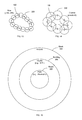
FIG. 1 shows a geofence circle 100, for example, defined by a GNSS center 110 and a radius (R) 120. Historically, a geofence 100 has been defined by a GNSS center 110 (latitude, longitude) and a fixed radius (R) 120. A mobile device wakes a specific user application in the mobile device whenever the geofence 100 is crossed (that is, when leaving 130 a geofenced area and/or entering 140 a geofence area).
FIG. 2 shows a block diagram of a first mobile device 200 creating a geofence (or a second mobile device 250 using the geofence). The first mobile device 200 includes an application processor 210, a modem 220 and a wireless local area network transceiver (WLAN transceiver 230).
The application processor 210 is a high power consumption part of the first mobile device 200 and executes one or more user applications 212 and code found in memory 214. The memory 214 includes program code to execute steps described herein. The memory 214 may be integrated with and/or separate from the application processor 210 and may be separate memory or contiguous memory.
The modem 220 is a low power consumption part of the first mobile device 200 and includes a GNSS receiver 222 and a wireless wide area network transceiver (WWAN transceiver 224) (e.g., a cellular transceiver). The application processor 210, when enabled, consumes more power than the modem 220, when enabled.
The WLAN transceiver 230 (e.g., a WiFi receiver or a WiFi transceiver) operates separately from the high power consuming application processor 210 and the low power consuming modem 220.
The first mobile device 200 may also include an optional (as indicated with a dotted box) wireless personal area network transceiver (PAN transceiver 240) (e.g., providing a Bluetooth transceiver and/or a near field effect (NFE) transceiver.
FIG. 3 shows a geofence circle 100A define by a plurality of RF fingerprints 150, in accordance with some embodiments of the present invention. Instead of a geofence 100 being defined with GNSS center 110 and a radius (R) 120, a geofence 100 is defined by a set of one or more overlapping and/or non-overlapping areas where each area is defined by an RF fingerprint 150. The RF fingerprint 150 may be defined by a coarse or fine granularity, as described below. A geofence 100 may be any arbitrary shape and size. A first mobile device 200 creates and collects an RF fingerprint 150 at one location from one or more received signals from a corresponding one or more transmitters separate from the second mobile device 250. The one or more transmitters may be one or more WWAN, WLAN and/or PAN transmitters.
For example, if the RF fingerprint 150 is comprised of only received WLAN signals (e.g., from access points), the first mobile device 200 may collect one or more MAC addresses (media access control address) to uniquely identify each access point. Optionally, the first mobile device 200 may also determine distance information, such as an RSSI (received signal strength indicator) and/or RTT (round-trip time) to further define a location via an RF fingerprint 150. A record of the RF environment at a location may uniquely identify the location. With an added uncertainty, coarseness, or granularity, the RF environment defines an area.
One or more areas define a geofence 100. When a second mobile device 250 crosses this defined geofence, either leaving 130 or entering 140, the second mobile device 250 wakes one or more user applications 212. Information that uniquely identifies a transmitter or location is saved as “absolute information.”
A device may communicate the absolute information along a first path. For example, a second mobile device 250 may receive one or more geofences 100 in an information or setup message. The absolute information may later be used to determine the absolute location of a transmitter (e.g., latitude and longitude of an access point or cellular base station or a MAC address for a table lookup).
Information that describes the relationship between these transmitters and the first mobile device 200 is saved as “relative information.” Relative information may later be used to determine the relative distances (e.g., in terms of RSSI and/or RTT) to these transmitters. Therefore, the absolute information corresponds to a location of a transmitter and relative information corresponds to a distance between each of these transmitters and the first mobile device 200. A device may communicate the relative information along a second path. For example, the relative information may be included in assistance data and received along a path normally used for such assistance data.
FIG. 4 shows a geofence annulus 102, in accordance with some embodiments of the present invention. This geofence 100 is shown as an annulus. An annulus is formed by the area bounded between two concentric circles (i.e., an outside perimeter geofence 102A and an inside perimeter geofence 102B). The outside perimeter geofence 102A of the annulus may be viewed as a first geofence. The inside perimeter geofence 102B of the annulus may be viewed as a second geofence. The first geofence and second geofence may operate such that a second mobile device 250 must be within the geofence annulus 102 before triggering a specific application. The application may be triggered by exiting 130 the annulus or entering 140 the annulus.
FIG. 5 shows a geofence oval 100B, in accordance with some embodiments of the present invention. A geofence oval 100B may be made up of several overlapping RF fingerprints 150. In this case a geofence 100 forms a geofence oval 100B.
FIG. 6 shows a free-formed enclosed geofence 100C, in accordance with some embodiments of the present invention. In this case, the geofence 100 is has an arbitrary shape and defines an enclosed area. A geofence 100 may define a set shape and either an enclosed area or a non-closed area.
FIG. 7 shows a free-formed open geofence 100D, in accordance with some embodiments of the present invention. A geofence 100 does not necessarily need to form an enclosed area. A geofence 100 may be placed across an entrance, door or opening to a building, office or conference room. A geofence 100 may be placed across a road or pathway. For example, when a second mobile device 250 crosses a geofence sent up across a public entrance of a building, a user application 212 may be triggered to notify, for example, someone in the building to welcome the individual carrying the second mobile device 250. A user application 212 may trigger based on crossing the geofence in a first direction 130D and/or in a second direction 140D.
FIG. 8 shows multiple geofences 100E, in accordance with some embodiments of the present invention. A geofence 100 may be a combination of closed and/or open geofences. In this case, the geofence 100 comprises two closed geofences defining two distinct areas as shown. Each part of the multiple geofences 100E is defined by one or more separate RF fingerprints 150, which overlap to form a separate geofence 100.
FIG. 9 shows a geofence 100F encompassing a single RF fingerprint 150, in accordance with some embodiments of the present invention. A single RF fingerprint 150 with a set uncertainty may be approximated by a circle. In this case, the geofence 100F corresponds to the single RF fingerprint 150 and vice versa.
FIG. 10 shows a geofence 100G encompassing a multiple RF fingerprints 150, in accordance with some embodiments of the present invention. A geofence 100 may “fill” an area to define a geofence at the boarder of the filled area.
FIG. 11 shows a difference between granularity 300 and uncertainty 160, in accordance with some embodiments of the present invention. Uncertainty 160 considers how accurate the RF fingerprint 150 may be determined. For example, MAC addresses from several access points may form an RF fingerprint 150 with a high degree of certainty (low uncertainty 160). In this case, the location of a first mobile device 200 is located at the intersection several access points, which only occurs in one tight area. The accuracy may be defined in meters, for example, five meters (corresponding to an uncertainty of 5 meters in location estimation). Granularity 300, on the other hand, is set based on the desired resolution of a geofence 100 and is at least as large or larger than the uncertainty. That is, uncertainty 160 is smaller or equal to granularity 300. As a hypothetical example, consider a certain actual position with a particular uncertainty 160 of an RF fingerprint 150 of ±1.0 meter in each direction such that the actual position may be estimated 50% if the time within an uncertainty of 1 meter of the actual position. On top of this RF fingerprint 150, set a granularity 300 to 10 meters. Therefore, accurate RF readings may be truncated and only coarse measurements or measurements with higher granularity taken.
For example, an RF fingerprint 150 is taken with several pieces of absolute information (e.g., several MAC addresses) to estimate a location within a certain uncertainty 160 (say 10 meters) of an actual location. Now a granularity 300, for example, is set to a city block. Therefore, only more granular signals (say a cell signal or cell signals) need to be examined.
Alternatively, high resolution RF fingerprints 150 may be truncated to represent a resolution set by the granularity 300. In this case, a one-way matrix (A) needs only the more granular or truncated signals. A geofence created or defined by a first mobile device may be communicated directly as one or more received RF fingerprints.
Alternatively, the RF fingerprints may be separated into absolute information (i.e., used to indicate an absolute location of a transmitter) and relative information (i.e., used to indicate a relative distance between the transmitter and mobile device). The absolute information may undergo a one-way function, such as a hash function, and placed as rows of a matrix called a one-way matrix (A). In this case, the geofence may be communicated directly as a one-way matrix (A). Alternatively, the geofence may be communicated directly as a signature (x) of a one-way matrix (A). Further details of a one-way matrix (A) and a signature (x) are described below.
FIG. 12 shows various levels of granularity 300, in accordance with some embodiments of the present invention. Levels of granularity include: (a) a city granularity 302 (e.g., MNC); (b) a city block granularity 304 (e.g., a cell ID); (c) a building granularity 306 (e.g., a WiFi coverage area); (d) a room granularity 308 (e.g., a 10 meter conference room); (e) an arm granularity 310 (e.g., a 1 meter granularity); and (f) a thumb granularity 312 (e.g., between a distance of a finger and direct contact).
FIGS. 13 and 14 show a geofence 100 with various levels of granularity 300, in accordance with some embodiments of the present invention. In FIG. 13, a fine level 320 of granularity is used to define a geofence 100. In FIG. 14, a coarse 330 of granularity is used to define a geofence even though each RF fingerprint 150 has a lower level of uncertainty 160 than the granularity 300 selected.
FIG. 15 shows relative levels of granularity 160 of transmitters, in accordance with some embodiments of the present invention. A WWAN (wireless wide area network, e.g., a cell) is coarser than a WLAN (wireless local area network, e.g., WiFi) is coarse than a PAN (personal area network, e.g., Bluetooth). A WWAN may be estimated with a granularity of a block 304. A WLAN may be estimated with a granularity of a building 306. A PAN may be estimated with a granularity of a room 308. Not shown are other levels of granularity 300, for example, a near field system providing a finer granularity than a PAN system.
FIGS. 16 and 17 show a first mobile device 200 and second mobile device 250 sharing a geofence 100, in accordance with some embodiments of the present invention. In FIG. 16, a first mobile device 200 defines and sends a geofence directly to one or more mobile devices 250 applying the geofence 100. Alternatively or in addition to the first mobile device 200 defining the geofence 100 may apply the geofence 100 within the first mobile device 200 defining the geofence, therefore, the geofence 100 is not necessarily communicated from the first mobile device 200. Communicating includes sending from a first mobile device 200 and/or receiving at a second mobile device 250.
In FIG. 17, a first mobile device 200 defining the geofence 100 may send the geofence 100 to a distribution server 400 in a first transmission. The distribution server 400 distributes the geofence 100 to one or more mobile devices 250 applying the geofence 100 in a second transmission. The geofence 100 sent to the distribution server 400 in the first transmission may be the same as the geofence 100 distribute by the distribution server 400 in the second transmission. Alternatively for the second transmission, the distribution server 400 may set a higher level of encryption, encoding or other means of hiding the geofence 100 than used in sending the first transmission.
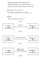
FIGS. 18 and 19 show methods to define and use a geofence 100, in accordance with some embodiments of the present invention. In FIG. 18, shown is a method 500 in a first mobile device 200 for defining a geofence 100. At 510, the first mobile device 200 collects at least one RF fingerprint 150, wherein the at least one RF fingerprint 150 comprises absolute information from a plurality of transmitters to create the geofence. At 520, the first mobile device 200 sends the absolute information from the first mobile device.
In some embodiment, the first mobile device 200 may also send relative information from the first mobile device 200 to a second mobile device 250, wherein the at least one RF fingerprint further comprises the relative information. The relative information may comprise distance information between the first mobile device 200 and the plurality of transmitters. The first mobile device 200 sending the relative information from the first mobile device 200 to the second mobile device 250 may comprise sending the relative information from the first mobile device 200 to a location server for inclusion in assistance data sent to the second mobile device 250. The first mobile device 200 may comprise sending the absolute information from the first mobile device 200 via a first path, and sending the relative information from the first mobile device 200 to the second mobile device 250 via a second path different from the first path.
In some embodiments, the geofence defines multiple disjointed areas. In some embodiments, the at least one RF fingerprint 150 comprises a plurality of RF fingerprints around at least one closed path. In some embodiments, the at least one RF fingerprint comprises a plurality of RF fingerprints along at least one open-loop path. In some embodiments, the absolute information comprises a granularity value, for example, any one of: a city granularity, a block granularity, a building granularity, a room granularity, an arm granularity, and a thumb granularity. The at least one RF fingerprint may comprise an NFC identifier (near-field communication identifier). The absolute information may comprise information to uniquely identify each of the plurality of transmitters. The absolute information may comprise a location of each of the plurality of transmitters.
In FIG. 19, shown is a method 600 in a second mobile device 250 for using a geofence 100 created by a first mobile device 200. At 610, the mobile device 250 receives absolute information, wherein the absolute information comprises or can indicate a location information of a plurality of transmitters and wherein at least one RF fingerprint comprises the absolute information of the plurality of transmitters to create the geofence.
At 620, the mobile device 250 determines if a breach of the geofence has occurred. A breach occurs when: (1) leaving a closed geofenced area 130; (2) entering closed geofenced area 140; and/or (3) crossing a geofence in an open or closed area.
At 630, the mobile device 250 wakes an application in the second mobile device based on the breach occurring.
The mobile device 250 may also receive relative information from the first mobile device 200 at the second mobile device 250, wherein the at least one RF fingerprint may further comprises the relative information. The mobile device 250 may receive the relative information from the first mobile device at a location server in assistance data from a location server. The mobile device 250 may receive the absolute information from the first mobile device via a first path, and receive the relative information from the first mobile device at the second mobile device via a second path different from the first path. The absolute information may comprise a granularity value.
FIGS. 20-24 show an RF fingerprint, in accordance with some embodiments of the present invention. A first mobile device 200 (the mobile device that is collecting RF fingerprints to define or create one or more geofences) records an identifier of each transmitter 700.
In FIG. 20, a first transmitter 702 (TX1), a second transmitter 704 (TX2) and a third transmitter 706 (TX3) transmit information that identifies the respective transmitter 700 (also referred to as absolute information). The distance between the transmitter and the first mobile device 200 defines relative information. Such relative information is optional and identifies where the first mobile device 200 is with respect to the transmitter 700. For example, a first access point (AP1) broadcasts its unique MAC address (MAC1). A second access point (AP2) broadcasts its unique MAC address (MAC2). A third access point (AP3) broadcasts its unique MAC address (MAC3). In this case, the RF fingerprint 150 may be defined by the three MAC addresses.
FIG. 21 shows three MAC addresses defining an example RF fingerprint 150. The RF fingerprint 150 includes absolute information. In this case, an RF fingerprint 150 is defined by a set of MAC addresses {MAC1, MAC2, MAC3}. FIG. 22 shows the RF fingerprint 150 may optionally be expanded to include relative information. The relative information in this example is distance information. FIG. 23 shows this distance information may be RSSI values. In this case, the RF fingerprint 150 is defined by a set of MAC addresses {MAC1, MAC2, MAC3} along with a corresponding set of RSSI values {RSSI1, RSSI2, RSSI3}. Similarly, FIG. 24 shows this distance information may be RTT values. In this case, the RF fingerprint 150 is defined by a set of MAC addresses {MAC1, MAC2, MAC3} along with a corresponding set of RTT values {RTT1, RTT2, RTT3}.
FIG. 25 shows a transition from transmitter information to a geofence, in accordance with some embodiments of the present invention. Transmitter information includes absolute information. Absolute information may be used to define an absolute location. Transmitter information may also include relative information. Relative information may be used to define a distance from an absolute location. For example, the relative information may be an RTT and/or RSSI. Transmitter information collected from a single location from several transmitters 700 comprises an RF fingerprint 700. That is, an RF fingerprint 150 includes transmitter information from multiple transmitters as received at a particular location. For example purposes, space for up to an arbitrary 50 transmitters is considered. A set of RF fingerprints 150 from one or more various locations along a path forms a geofence. A geofence includes a variable number of locations each containing an RF fingerprint 150. The example shown shows RF fingerprints 150 from an arbitrary number of 100 locations.
FIGS. 26-28 show various ways to transmit a geofence, in accordance with some embodiments of the present invention. A first mobile device 200 may send a second mobile device 250: (1) a geofence in the clear (FIG. 26)—no privacy; (2) a one-way matrix (A) 740 for the geofence (FIG. 27)—some privacy; or (3) a signature (x) 750 of the one-way matrix (A) 740 of the geofence—strong privacy. An intermediary distribution server 400, as previously discussed, may be placed between the first mobile device 200 and the second mobile device 250 in order to perform the one-way function of a geofence and/or provide the signature (x) 750 of a one-way matrix (A) 740 and/or distribute the geofence (in the form of a geofence, a one-way matrix (A) 740 or a signature (x) 750) to one or more second mobile devices 250 as they become available or request the geofence.
In FIG. 26, a geofence is transmitted without encrypting or hiding the absolute information of the geofence. That is, a geofence may be transmitted from a first mobile device 200 defining or creating a geofence to one or more second mobile devices 250 using or applying the geofence. When a geofence is transmitted in the clear, the second mobile devices 250 receiving and applying the geofence directly know the locations of the geofence from the communicated geofence.
In FIG. 27, a one-way matrix (A) 740 (e.g., hashed matrix) is communicated. A hash function is used here as an example of a one-way function. The absolute information is collected by a first mobile device 200 or an intermediary distribution server 400. The absolute information is hashed by the first mobile device 200 or the intermediary distribution server 400, which creates the one-way matrix (A) 740. The one-way matrix (A) 740 is a hash of the absolute information. In some embodiments, a second mobile device 250 receives the hashed absolute information. In other embodiments, the first mobile device 200 or an intermediary distribution server 400 solves for a signature vector (x) 750 from Ax=0. In these embodiments, the second mobile device 250 receives the signature vector (x) 750 of the one-way matrix (A) or the hashed absolute information.
The second mobile device 250 using a geofence does not know what transmitters 700 create a particular hash without first being in range of that transmitter 700 to check a transmitter's hash, as explained below. For example, assume the transmitter 700 is an access point and the absolute information is a MAC address. Instead of transmitting the MAC address as part of the transmitter information, the MAC address is used as an input to a hash function. The output of the hash function is used to hash the transmitter information and thus a hashed geofence. Due to the limited number of bits (e.g., 6 octets, 6 bytes or 48 bits) in a MAC address, the hashed absolute information may be theoretically “reversed” by sorting output values from all possible input values applied to a hash function. For larger length input values, such reverse engineering of the hash function becomes impractical.
In FIG. 28, a signature (x) 750 of the one-way matrix (A) is sent from the first mobile device 200 to the second mobile device 250. Again, a hash function is used here as an example of a one-way function. Rather than communicating either the unhashed absolute information in the clear or a hash of the absolute information, a signature (x) 750 of the hash of the absolute information is communicated, as explained in more detail below. Communicating a signature (x) 750 often requires less bandwidth than communicating a set of absolute information or the one-way matrix (A) 740. The first mobile device 200 and the second mobile device 250 may be the same mobile device or different mobile devices. The first mobile device 200 and the second mobile device 250 may communicate directly in a point-to-point fashion or indirectly through a distribution server 400.
FIGS. 29 and 30 show a method to encode MAC addresses by applying a one-way function, in accordance with some embodiments of the present invention. For example purposes, up to 50 access points, each identified with a 6-byte MAC address, are considered. A length of 50 transmitters 700 is considered a practical maximum number of transmitters 700 that can be received from one location, however, for a large geofenced area with a large number of fingerprints 150, the maximum number of transmitters may be substantially higher. Examples presented here have arbitrarily been set to 50. Instead of 50, a lower number may be used (e.g., 40, 30 or 20) or a higher number may be use (e.g., 100, 1000 or 10000).
In FIG. 29, a MAC vector 710 contains up to 50 MAC addresses. Here, data applied to a one-way algorithm 720 (e.g., a hash function) results in a value. Each element of the MAC vector 710 is applied to the one-way algorithm 720 and results in a one-way vector (h) 730. If a lower number of transmitters 700 are detected when making an RF fingerprint 150, extra positions in the vector may be zero filled. Each element of the MAC vector 710 is applied to one-way function such as a cryptographic hash algorithm or cryptographic hash function. In the text that follows, we will use the terms “hash algorithm” and “hash function” to refer to “cryptographic hash algorithm” and “cryptographic hash function” as an example of any one-way algorithm or one-way function. For the particular hash algorithm selected, an input is 6 bytes long (6-byte word) and an output is 128 bytes long (128-byte word). That is, to obscure the 6-byte MAC address, the hash algorithm returns a 128 byte output. The hash algorithm is a one-way function meaning that an input leads to an output through a function that cannot be reversed. The result of component-wise hashing of the MAC vector 710 of 6-byte elements (MAC1, MAC2, MAC3, . . . , MAC50) is a vector of 128-byte elements (hash1, hash2, hash3, . . . , hash50). In the case shown, the hash algorithm converts a 6-byte word for 50 transmitters 700 (shown as a column vector of 50 elements defining MAC vector 710) into a 128-byte word for the 50 transmitter 700 (to result in a column vector of 50 elements defining one-way vector (h) 730).
In FIG. 30, the one-way vector (h) 730 is translated to 64 2-byte words by 50 matrix to define one-way matrix (A) 740. That is, one 128-byte element is subdivided into 64 segments that are 2 bytes each. Each 2-byte segment is in turn represented as an element in the Galois field of 216 elements depicted as GF(216). For information on Galois fields (finite fields), please refer to by Lidl, Rudolf; Niederreiter, Harald (1997), Finite Fields (2nd ed.), Cambridge University Press, ISBN 0-521-39231-4. Therefore, a 50 by 1 vector is converted to a 50 by 64 matrix. For example, a MAC vector 710 is converted to a one-way vector (h) 730. The number of subdivisions is arbitrary as long as the number of transmitters 700 (here 50) is less than the number of subdivisions (here 64). The resulting subdivided hash values in matrix form are referred to as the ‘A’ matrix, the hash matrix (A), or the one-way matrix (A) 740. As shown, the one-way matrix (A) 740 is 50 by 64. In the description that follows, all algebraic operations are performed over GF(216) without further specification.
FIG. 31 shows a relationship between a one-way matrix (A) 740 and a signature (x) 750, both defined over GF(216), in accordance with some embodiments of the present invention. The one-way matrix (A) 740 is derived from a one-way function. Another one-way function may be used, for example, a hash function, to create a one-way matrix (A). 740. A product of the one-way matrix (A) 740 and the signature (x) 750 is set to a zero vector (0). The matrix equation relating the one-way matrix (A) 740 to the signature (x) 750 is Ax=0.
In the example given, the one-way matrix (A) 740 is a 50 by 64 matrix, the signature (x) 750 is a 64 by 1 vector, and 0 is a 50 by 1 vector. Because the one-way matrix (A) 740 has a number of rows is less than the number of column (rows 50<columns 64), and both A and x are defined over a field (Galois field GF(216)), the solution to Ax=0 is not unique. In other words, several possible solutions to Ax=0 exist. All solutions to x can be found following the Gaussian elimination algorithm in linear algebra. Among all solutions, one solution is selected at random as the signature (x) 750. Information on the Gaussian elimination algorithm can be found in David S. Dummit and Richard M. Foote, Abstract Algebra (3rd Edition), Wiley, ISBN-10: 0471433349.
FIG. 32 shows a method to decode a scanned MAC addresses by applying a one-way algorithm 720, in accordance with some embodiments of the present invention. A second mobile device 250 applying a geofence first receives a signature (x) 750 either directly from a first mobile device 200 or indirectly from a distribution server 400. To decode the signature (x) 750, a second mobile device 250 scans for MAC addresses. A found MAC address is an input to a one-way algorithm 720. The same one-way algorithm 720 used to encode the geofence is used in the decoding process. As shown, the MAC address found during a scan becomes a 6-byte input to the one-way algorithm 720 (e.g., padded by “00” or concatenated with a type index), which results in a 128-byte output. Again the hash is subdivided into 2-byte segments to result in a one-way vector (h) 760 with 1 row and 64 columns. For convenience of display, the figure shows a transpose (hT) of the one-way vector (h) 760 as a column vector of 64 elements.
Though the figure shows a MAC address of an access point as the absolute information that is hashed, absolute information from another transmitter 700 may be hashed. For example, the cell ID from a cellular transmitter or other WWAN transmitter may be encoded and decoded with the one-way algorithm 720. A universal unique identifier from a Bluetooth transmitter or other personal area network (PAN) may also be encoded and decoded with a hash algorithm. Similarly, an identifier from a near-field communication (NFC) transmitter may be encoded and decoded with a hash algorithm.
FIG. 33 shows a relationship between a one-way vector (h) 760 and a signature (x) 750, in accordance with some embodiments of the present invention. To determine whether a scanned transmitter belongs to a particular geofence, a matrix product of the one-way vector (h) 760 and the signature (x) 750 is formed, over GF(216). The vector equation relating the one-way vector (h) 760 to the signature (x) 750 is: hx=0.
In the example given, the one-way vector (h) 760 is a row vector of 64 elements, the signature (x) 750 is a column vector of 64 elements, and the resulting product is a scalar (1 by 1). If the result is zero, the scanned transmitter is most likely in the geofence. If the result is not zero, the scanned transmitter is not in the geofence. In this manner, if a first mobile device 200 is not within the reception area of a transmitter 700 in the geofence, the location of the geofence remains unknown.
FIGS. 34 and 35 show a method to encode and decode distance information, respectively, in accordance with some embodiments of the present invention. The relative information includes distance information such as RTT and/or RSSI. Again, a MAC address is shown but other absolute information may be used.
In FIG. 34, a MAC address is the input parameter to a key derivation function (KDF) 770 in the encoder. The KDF 770 shown uses a 6-byte word or an 8-byte word as an input, which results in a 128-bit or 16-byte output. The input length of the KDF 770 may be regulated by the longest expected absolute information. If the length of the input to the KDF 770 is longer than the absolute information, the input may be zero padded. Meanwhile, distance information (such as at RTT or RSSI) is provided to an authenticated encryption (AE) algorithm 810, which used the key just determined to encrypt the distance information. The output of the AE algorithm 810 is the encrypted distance information. The encrypted distance information is sent from the first mobile device 200 to the second mobile device 250 either directly or via a distribution server 400.
In FIG. 35, a scan reveals a MAC address. The scanned MAC address is an input to a duplicate KDF 770 in the decoder. That is, the KDF 770 used during encoding is equivalent to the KDF 770 used during the decryption. The output of the KDF 770 is a key. In the case shown, a 6-byte input is converted to at 128-bit output where the absolute information is a MAC address and the output of the KDF 770 is a key. Next, the encrypted distance information is entered to an AE algorithm 920. The AE algorithm 920 in the decoder decrypts and the AE algorithm 810 in the encoder encrypts. The AE algorithm 920 also receives the key from the KDF 770. The AE algorithm 920 outputs the decrypted distance information if the correct key is generated from the KDF 770. If an improper key is used, the AE algorithm 920 generates an error signal that indicates the decoding results are erroneous or unauthenticated.
FIG. 36 shows a process to encrypt 800 and decrypt 900 both absolute and relative information, which define a geofence, in accordance with some embodiments of the present invention. A geofence is defined by a first vector 802 containing absolute information for a number of transmitters 700. Optionally, a second vector 804 contains corresponding relative information for the transmitters 700. To encode the geofence, the individual absolute information (e.g., absolute information1 just collected by the first mobile device) becomes input to a hash algorithm or other one-way algorithm 720. The resulting hash is subdivided for each transmitter resulting in a one-way matrix (A) 740 for all transmitters 700 in the geofence. In 820, a signature (x) 750 is solved from Ax=0. The signature (x) 750 results in Ax being equal to zero. The signature (x) 750 is non-trivial (not equal to a zero vector) and not unique. The signature (x) 750 may be a random one of the solutions for from the matrix equation Ax=0. In some embodiments at 830, the signature (x) 750 is communicated from the first mobile device 200 to a second mobile device 250. The first mobile device 200 defines and may encode or encrypt the geofence. Alternatively, encoding may occur on a distribution server 400. The second mobile device 250 applies the geofence to determine when the second mobile device 250 crosses a line defined by the geofence.
The second mobile device 250 scans for absolute information. Found absolute information enters the one-way algorithm 720 and emerges has a one-way vector (h) 760. At 910, the second mobile device 250 performs a scalar product of the signature (x) 750 and the one-way vector (h) 760 to compute the inner product hx and determine if the scalar product of hx is zero. If not zero, the transmitter 700 is not within an RF fingerprint 150. If zero, the found absolute information has likely found transmitter 700 in the RF fingerprint 750 in the geofence. This process may repeat for each absolute information found during the scan.
In some embodiments, relative information is also collected and used in a geofence. To encode the relative information, a key is generated by a KDF 770 using the absolute information as input. The key is used by an AE algorithm 810 to encrypt the relative information. For example, absolute information1 generates key1 and is applied to an AE algorithm 810 converting relative information1 to encrypted relative information1. At 840, the encrypted relative information is communicated to the second mobile device 250. The encrypted relative information may be sent directly from the first mobile device 200 or indirectly from a distribution server 400 or a position determining entity (PDE) or the like as assistance data (AD).
As discussed above, the second mobile device 250 scans for absolute information. Found absolute information enters KDF 770 and emerges has a possible key. At 920, the second mobile device 250 applies the key (when hx=0) to the AE algorithm 920 to decrypt the relative information. When hx< >0, then a transmitter 700 in an RF fingerprint has not been identified. The second mobile device 250 can only determine a rough location of the RF fingerprint 150 when not all of the absolute information is scanned and found by the first mobile device 200. This process may repeat for each absolute information found during the scan.
During encryption, if absolute information is used with more than one RF fingerprint 150 with absolute information paired with relative information, the RF fingerprint 150 may be indexed. For example, if 100 RF fingerprints are taken at a corresponding 100 locations to create a geofence, each RF fingerprint 150 may be indexed by a number 0 to 99. The absolute information may be concatenated with the index before entering the KDF 770 thereby creating a unique key for each absolute information-index pair. In this manner each RF fingerprint 150 has a unique index associated with it and each absolute information-index pair creates a valid key for the AE algorithm 810. For example, a particular MAC address and index both associated with an RF fingerprint are feed into a KDF algorithm 810 to generate a key. This key is used by the AE algorithm 810 to encrypt the relative information.
During decryption, scanned absolute information may be concatenated with a generated index. For example, a maximum value of the generated index may be communicated within the assistance data carrying the encrypted relative information. Alternatively, the maximum value may be set as a maximum predetermined threshold value. For each scanned absolute information found to where hx is computed as 0, a generated index from one to the maximum value may be concatenated with the absolute information to generate a corresponding key for each index. For example, assistance data may communicate both the encrypted relative information and the number of RF fingerprints 150. If a MAC address matches the signature (by hx=0) then a set of keys may be generated by concatenating the scanned MAC address (absolute information) with a generated index to generate a possible key from the KDF 770 in the decoder. The possible keys may be applied to the encrypted relative information (e.g., encrypted RTT or RSSI) to determine an index for a possible RF fingerprint 150. After indexes for a set of keys decode possible relative information, only these indexes are concatenated with the scanned absolute information thereby limiting processing computation.
Alternatively, or in addition to, a type index (e.g., a 2-bit index) may be used to communicate what type of receiver was used in the RF fingerprint collection. This type index may be used to distinguish different absolute information have the same identifier. For example, “00” means a Cell ID receiver was used, “01” means a MAC address receiver was used and “10” means a Bluetooth receiver was used. The type index is concatenated to the absolute information before executing the hash algorithm in the encoder for the first mobile device 200. In the decoder, an index of the receiver-type is similarly concatenated by the second mobile device 250 thereby distinguishing two transmitters that may happen to have an identical identifier. For example, an access point MAC address of “00:00:00:00:12:34” appears identical to a Bluetooth MAC address of “00:00:00:00:12:34.” Appending the access point MAC address results in “{01,00,00,00,00,12,34}” and appending the Bluetooth MAC address results in “{10,00,00,00,00,12,34}” being applied to the one-way algorithm 720 and the KDF 770 thereby guaranteeing a unique hash result and a unique key, respectfully.
In some embodiments during the decryption process, only a maximum threshold number of scanned absolute information is processed to determine an RF fingerprint 150. For example, up to five MAC addresses (from AP with the five strongest signals) may be used to find an RF fingerprint 150. The same number or more absolute information is used for encoding or encrypting.
FIGS. 37 and 38 show methods to communicate and use a geofence, in accordance with some embodiments of the present invention.
In FIG. 37, shown is a method 1000 for communicating a geofence. At 1010, a first mobile device 200 provides the geofence based on the at least one RF fingerprint 150, wherein each RF fingerprint 150 comprises transmitter information from a plurality of transmitters 700, wherein the transmitter information comprises absolute information. Next at 1020, the first mobile device 200 hashes the absolute information for each RF fingerprint 150 to form a one-way matrix (A) 740. At 1030, the first mobile device 200 solves an equation (or system of equations) for a signature (x) 750 from the one-way matrix (A) 740. At 1040, the first mobile device 200 transmits the signature vector (x) 750 for a second mobile device 250 to use.
In FIG. 38, shown is a method 1100 for using a geofence by a second mobile device 250. At 1110, the second mobile device 250 receives a signature vector (x) 750. At 1120, the second mobile device 250 scans for a transmitter 700 transmitting absolute information. At 1130, the second mobile device 250 hashes the absolute information to form a one-way vector (h) 760. At 1140, the second mobile device 250 determines that a product of the signature vector (x) 750 and the one-way vector (h) 760 indicates the transmitter was used to create the signature vector (x) 750, thereby determining the transmitter is part of the geofence.
FIG. 39 shows an optional distribution server 400, in accordance with some embodiments of the present invention. The distribution server 400 includes a process 402, memory 404 and a transceiver 406. The processor 402 may be implemented with one or more processing units, which are described below. The memory 404 contains software modules to receive a first transmission, which includes a geofence, a one-way matrix (A) or a signature (x) of a one-way matrix (A). The memory 404 also contains software modules to transmit a second transmission, which includes a geofence, a one-way matrix (A) or a signature (x) of a one-way matrix (A). If a geofence is received in the first transmission, the distribution server 400 may simply transmit the geofence or alternatively may convert the geofence to a one-way matrix (A) or a signature (x) before transmitting the second transmission. If a one-way matrix (A) is received in the first transmission, the distribution server 400 may simply transmit the one-way matrix (A) or alternatively may convert the one-way matrix (A) to a signature (x) and then transmit the signature (x) in the second transmission. The transceiver 406 includes a receiver to receive the first transmission and a transmitter to transmit the second transmission.
The methodologies described herein may be implemented by various means depending upon the application. For example, these methodologies may be implemented in hardware, firmware, software, or any combination thereof. For a hardware implementation, the processing units may be implemented within one or more application specific integrated circuits (ASICs), digital signal processors (DSPs), digital signal processing devices (DSPDs), programmable logic devices (PLDs), field programmable gate arrays (FPGAs), processors, controllers, micro-controllers, microprocessors, electronic devices, other electronic units designed to perform the functions described herein, or a combination thereof.
For a firmware and/or software implementation, the methodologies may be implemented with modules (e.g., procedures, functions, and so on) that perform the functions described herein. Any machine-readable medium tangibly embodying instructions may be used in implementing the methodologies described herein. For example, software codes may be stored in a memory and executed by a processor unit. Memory may be implemented within the processor unit or external to the processor unit. As used herein the term “memory” refers to any type of long term, short term, volatile, nonvolatile, or other memory and is not to be limited to any particular type of memory or number of memories, or type of media upon which memory is stored.
If implemented in firmware and/or software, the functions may be stored as one or more instructions or code on a computer-readable medium. Examples include computer-readable media encoded with a data structure and computer-readable media encoded with a computer program. Computer-readable media includes physical computer storage media. A storage medium may be any available medium that can be accessed by a computer. By way of example, and not limitation, such computer-readable media can comprise RAM, ROM, EEPROM, CD-ROM or other optical disk storage, magnetic disk storage or other magnetic storage devices, or any other medium that can be used to store desired program code in the form of instructions or data structures and that can be accessed by a computer; disk and disc, as used herein, includes compact disc (CD), laser disc, optical disc, digital versatile disc (DVD), floppy disk and Blu-ray disc where disks usually reproduce data magnetically, while discs reproduce data optically with lasers. Combinations of the above should also be included within the scope of computer-readable media.
In addition to storage on computer readable medium, instructions and/or data may be provided as signals on transmission media included in a communication apparatus. For example, a communication apparatus may include a transceiver having signals indicative of instructions and data. The instructions and data are configured to cause one or more processors to implement the functions outlined in the claims. That is, the communication apparatus includes transmission media with signals indicative of information to perform disclosed functions. At a first time, the transmission media included in the communication apparatus may include a first portion of the information to perform the disclosed functions, while at a second time the transmission media included in the communication apparatus may include a second portion of the information to perform the disclosed functions.
The previous description of the disclosed aspects is provided to enable any person skilled in the art to make or use the present disclosure. Various modifications to these aspects will be readily apparent to those skilled in the art, and the generic principles defined herein may be applied to other aspects without departing from the spirit or scope of the disclosure.

Claims (31)

What is claimed is:
1. A method for communicating a geofence, the method comprising:
obtaining the geofence defined with reference to a plurality of transmitters, including obtaining transmitter information from the plurality of transmitters, wherein the transmitter information comprises both absolute information and relative information;
applying a one-way function to the absolute information for each transmitter of the plurality of transmitters to form a one-way matrix (A), wherein the one-way function is not applied to the relative information;
solving an equation for a signature vector (x) from the one-way matrix (A); and
transmitting the signature vector (x) for a mobile device to use for determining a breach of the geofence by the mobile device.
2. The method of claim 1, wherein the absolute information comprises a cellular identifier (Cell ID).
3. The method of claim 1, wherein the absolute information comprises a Bluetooth identifier (Bluetooth ID).
4. The method of claim 1, wherein the absolute information comprises a media access control address (MAC address).
5. The method of claim 1, wherein the relative information comprises distance information.
6. The method of claim 5, wherein the distance information comprises a round-trip time (RTT).
7. The method of claim 5, wherein the distance information comprises a received signal strength indicator (RSSI).
8. The method of claim 1, wherein applying the one-way function to the absolute information for each transmitter of the plurality of transmitters to form the one-way matrix (A) comprises:
executing the one-way function on the absolute information to form a resulting one-way value for each transmitter;
subdividing the resulting one-way value for each transmitter into a plurality of matrix elements; and
forming, for each transmitter, a row of the one-way matrix (A) with the plurality of matrix elements.
9. The method of claim 1, wherein the one-way function is a hash function.
10. The method of claim 1, wherein transmitting the signature vector (x) for the mobile device to use the geofence comprises transmitting the signature vector (x) without the absolute information.
11. The method of claim 1, wherein transmitting the signature vector (x) for the mobile device to use the geofence comprises transmitting the signature vector (x) without the one-way matrix (A).
12. The method of claim 1, the method further comprising:
forming a key from the absolute information;
encrypting the relative information with the key to form encrypted relative information; and
transmitting the encrypted relative information for the mobile device to use.
13. The method of claim 12, wherein encrypting the relative information with the key to form the encrypted relative information comprises using an authenticated encryption algorithm (AE algorithm).
14. The method of claim 12, wherein forming the key from the absolute information comprises using a key derivation function (KDF).
15. The method of claim 1, wherein transmitting the signature vector (x) for the mobile device to use comprises transmitting by a first mobile device.
16. The method of claim 1, wherein transmitting the signature vector (x) for the mobile device to use comprises transmitting by a distribution server.
17. A device for communicating a geofence defined with reference to transmitter information from a plurality of transmitters, wherein the transmitter information comprises both absolute information and relative information, the device comprising:
a processor comprising:
a one-way function module comprising:
an input port configured to receive the absolute information;
a one-way function configured to convert the absolute information to a one-way value, wherein the relative information is not converted to the one-way value; and
an output port configured to obtain the one-way value;
a solving module coupled to the one-way function module to solve for a signature (x) from the one-way value, wherein the solving module comprises:
an input port configured to receive the one-way value;
and
an output port configured to provide the signature (x); and
a transmitter coupled to the processor and configured to transmit the signature (x) for a mobile device to use for determining a breach of the geofence by the mobile device.
18. The device of claim 17, wherein the solving module solves for the signature (x) from the one-way value from an equation Ax=0.
19. The device of claim 17, wherein the processor further comprises an encryption module configured to convert the relative information to encrypted relative information using a key derived from the absolute information, wherein the encryption module comprises:
an input port configured to receive the relative information;
an output port configured to provide the encrypted relative information;
wherein the transmitter is further configured to transmit the encrypted relative information.
20. A device for communicating a geofence, the device comprising:
means for obtaining the geofence defined with reference to a plurality of transmitters, including obtaining transmitter information from the plurality of transmitters, wherein the transmitter information comprises both absolute information and relative information;
means for applying a one-way function to the absolute information for each transmitter of the plurality of transmitters to form a one-way matrix (A) wherein the one-way function is not applied to the relative information;
means for solving an equation for a signature vector (x) from the one-way matrix (A); and
means for transmitting the signature vector (x) for a mobile device to use for determining a breach of the geofence by the mobile device.
21. The device of claim 20, wherein the means for applying the one-way function to the absolute information for each transmitter of the plurality of transmitters to form the one-way matrix (A) comprises:
means for executing the one-way function on the absolute information to form a resulting one-way value for each transmitter;
means for subdividing the resulting one-way value for each transmitter into a plurality of matrix elements; and
means for forming, for each transmitter, a row of the one-way matrix (A) with the plurality of matrix elements.
22. The device of claim 20, wherein the means for transmitting the signature vector (x) for the mobile device to use the geofence comprises means for transmitting the signature vector (x) without the absolute information.
23. The device of claim 20, wherein the means for transmitting the signature vector (x) for the mobile device to use the geofence comprises means for transmitting the signature vector (x) without the one-way matrix (A).
24. The device of claim 20, the device further comprising:
means for forming a key from the absolute information;
means for encrypting the relative information with the key to form encrypted relative information; and
means for transmitting the encrypted relative information for the mobile device to use.
25. A non-transient computer-readable storage medium including program code stored thereon for communicating a geofence by a device, comprising program code to:
obtain the geofence defined with reference to a plurality of transmitters, including obtaining transmitter information from the plurality of transmitters, wherein the transmitter information comprises both absolute information and relative information;
apply a one-way function to the absolute information for each transmitter of the plurality of transmitters to form a one-way matrix (A), wherein the one-way function is not applied to the relative information;
solve an equation for a signature vector (x) from the one-way matrix (A); and
transmit the signature vector (x) for a mobile device to use for determining a breach of the geofence by the mobile device.
26. A method for using a geofence by a mobile device, the geofence defined with reference to a plurality of transmitters, the method comprising:
receiving a signature vector (x) at the mobile device, wherein the signature vector (x) is computed using absolute information associated with the plurality of transmitters that define the geofence without reference to relative information associated with the plurality of transmitters, wherein the signature vector is used for determining a breach of the geofence by the mobile device;
scanning for a signal of a transmitter, wherein the signal comprises absolute information of the transmitter;
applying a one-way function to the absolute information to form a one-way vector (h), wherein the one-way function is not applied to any relative information; and
in response to determining that a product of the signature vector (x) and the one-way vector (h) indicates that the absolute information of the transmitter was used to create the signature vector (x), determining that the transmitter is one of the plurality of transmitters referenced in the definition of the geofence.
27. The method of claim 26, wherein the relative information comprises distance information.
28. The method of claim 26, further comprising:
receiving encrypted relative information for the mobile device to use;
forming a key from the absolute information; and
decrypting the encrypted relative information with the key to form the relative information.
29. A mobile device for using a geofence defined with reference to a plurality of transmitters, the mobile device comprising:
a receiver configured to:
receive a signature vector (x) at the mobile device, wherein the signature vector (x) is computed using absolute information associated with the plurality of transmitters that define the geofence without reference to relative information associated with the plurality of transmitters; and
scan for a signal of a transmitter, wherein the signal comprises absolute information of the transmitter; and
a processor coupled to the receiver and configured to use the signature vector for determining a breach of the geofence by the mobile device by being configured to:
apply a one-way function to the absolute information to form a one-way vector (h), wherein the one-way function is not applied to any relative information; and
in response to determining that a product of the signature vector (x) and the one-way vector (h) indicates that the absolute information of the transmitter was used to create the signature vector (x), determine the transmitter is one of the plurality of transmitters referenced in the definition of the geofence.
30. A mobile device for using a geofence, the geofence defined with reference to a plurality of transmitters, the mobile device comprising:
means for receiving a signature vector (x) at the mobile device, wherein the signature vector (x) is computed using absolute information associated with the plurality of transmitters that define the geofence without reference to relative information associated with the plurality of transmitters, wherein the signature vector is used for determining a breach of the geofence by the mobile device;
means for scanning for a signal of a transmitter, wherein signal comprises absolute information of the transmitter;
means for applying a one-way function to the absolute information to form a one-way vector (h), wherein the one-way function is not applied to any relative information; and
means for determining that the transmitter is one of the plurality of transmitters referenced in the definition of the geofence, in response to determining that a product of the signature vector (x) and the one-way vector (h) indicates that the absolute information of the transmitter was used to create the signature vector (x).
31. A non-transient computer-readable storage medium including program code stored thereon for using a geofence by a mobile device, the geofence defined with reference to a plurality of transmitters, comprising program code to:
receive a signature vector (x) at the mobile device, wherein the signature vector (x) is computed using absolute information associated with the plurality of transmitters that define the geofence without reference to relative information associated with the plurality of transmitters, wherein the signature vector is used for determining a breach of the geofence by the mobile device;
scan for a signal of a transmitter, wherein signal comprises absolute information of the transmitter;
apply a one-way function to the absolute information to form a one-way vector (h), wherein the one-way function is not applied to any relative information; and
in response to determining that a product of the signature vector (x) and the one-way vector (h) indicates that the absolute information of the transmitter was used to create the signature vector (x), determine that the transmitter is one of the plurality of transmitters referenced in the definition of the geofence.
US14/056,788 2013-07-17 2013-10-17 Communicating RF fingerprint-based geofences Expired - Fee Related US9414193B2 (en)

Priority Applications (3)

Application Number Priority Date Filing Date Title
US14/056,788 US9414193B2 (en) 2013-07-17 2013-10-17 Communicating RF fingerprint-based geofences
PCT/US2014/044885 WO2015009438A1 (en) 2013-07-17 2014-06-30 Communicating rf fingerprint-based geofences
US15/192,490 US9986377B2 (en) 2013-07-17 2016-06-24 Geofences based on RF fingerprints

Applications Claiming Priority (3)

Application Number Priority Date Filing Date Title
US201361847493P 2013-07-17 2013-07-17
US201361847465P 2013-07-17 2013-07-17
US14/056,788 US9414193B2 (en) 2013-07-17 2013-10-17 Communicating RF fingerprint-based geofences

Publications (2)

Publication Number Publication Date
US20150023502A1 US20150023502A1 (en) 2015-01-22
US9414193B2 true US9414193B2 (en) 2016-08-09

Family

ID=52343584

Family Applications (3)

Application Number Title Priority Date Filing Date
US14/056,780 Active 2034-08-27 US9386415B2 (en) 2013-07-17 2013-10-17 Geofences based on RF fingerprints
US14/056,788 Expired - Fee Related US9414193B2 (en) 2013-07-17 2013-10-17 Communicating RF fingerprint-based geofences
US15/192,490 Active US9986377B2 (en) 2013-07-17 2016-06-24 Geofences based on RF fingerprints

Family Applications Before (1)

Application Number Title Priority Date Filing Date
US14/056,780 Active 2034-08-27 US9386415B2 (en) 2013-07-17 2013-10-17 Geofences based on RF fingerprints

Family Applications After (1)

Application Number Title Priority Date Filing Date
US15/192,490 Active US9986377B2 (en) 2013-07-17 2016-06-24 Geofences based on RF fingerprints

Country Status (2)

Country Link
US (3) US9386415B2 (en)
WO (2) WO2015009438A1 (en)

Cited By (5)

* Cited by examiner, † Cited by third party
Publication number Priority date Publication date Assignee Title
US9622047B1 (en) 2015-11-06 2017-04-11 International Business Machines Corporation WiFi-fingerprint based indoor localization map
CN109298396A (en) * 2018-11-12 2019-02-01 广州杰赛科技股份有限公司 A kind of unmanned plane localization method, device and computer readable storage medium
US10379514B2 (en) * 2016-07-27 2019-08-13 Ademco Inc. Systems and methods for controlling a home automation system based on identifying a user location via a wi-fi fingerprint
CN111031473A (en) * 2019-12-05 2020-04-17 上海航天控制技术研究所 Fingerprint identification and positioning method for mobile base station
US11122424B1 (en) 2019-05-14 2021-09-14 Hood Mountain, LLC Systems, methods and apparatus for data privacy protection based on geofence networks

Families Citing this family (38)

* Cited by examiner, † Cited by third party
Publication number Priority date Publication date Assignee Title
US9544728B2 (en) * 2013-03-15 2017-01-10 Intel Corporation Systems and methods for approximating geo-fencing locations
US9651673B2 (en) * 2013-03-15 2017-05-16 Qualcomm Incorporated Energy conservation apparatus for geofence applications
US9386415B2 (en) 2013-07-17 2016-07-05 Qualcomm Incorporated Geofences based on RF fingerprints
US9521521B2 (en) 2013-09-25 2016-12-13 Gamesys Ltd. Systems, methods, and apparatus for geolocation platform mechanics
US20150260850A1 (en) * 2014-03-12 2015-09-17 Marvell World Trade Ltd Method and apparatus for geo-fence detection
US20150281886A1 (en) * 2014-03-27 2015-10-01 Itai Steiner Method and apparatus for improved geofencing background
KR102163339B1 (en) * 2014-08-11 2020-10-08 에스케이플래닛 주식회사 Content providing system based on recognization of local information
US9646477B2 (en) * 2014-09-12 2017-05-09 Ncr Corporation Branch device geo-fencing pairing security
US9762722B2 (en) * 2014-11-17 2017-09-12 International Business Machines Corporation Location-based and time-based mobile device security
US9723439B2 (en) 2015-01-26 2017-08-01 Intel IP Corporation Apparatus, system and method of neighbor awareness networking (NAN) geo-fencing
CN104640205B (en) * 2015-02-09 2018-08-28 重庆邮电大学 The mobile phone positioning system and method for field strength and difference fingerprint are utilized under the conditions of macro base station
CN105101072A (en) 2015-05-19 2015-11-25 小米科技有限责任公司 Location method and location device
CN108028858B (en) * 2015-08-27 2020-12-18 匹维托软件公司 Mobile computing device, method for operating mobile computing device, and medium
CN105357014B (en) * 2015-11-25 2018-09-21 东南大学 Wireless device radio frequency method for extracting fingerprint feature based on difference constellation trajectory diagram
US9560482B1 (en) * 2015-12-09 2017-01-31 Honeywell International Inc. User or automated selection of enhanced geo-fencing
US10417663B2 (en) 2016-10-28 2019-09-17 International Busienss Machines Corporation Ephemeral geofence campaign system
US10966049B2 (en) * 2016-12-29 2021-03-30 Cuebiq S.R.L. Systems and methods to collect location data by using a dynamic geofencing methodology
US9924315B1 (en) 2017-01-03 2018-03-20 International Business Machines Corporation Dynamic geofence
US9820097B1 (en) * 2017-01-05 2017-11-14 International Business Machines Corporation Geofence location detection
DK179479B9 (en) 2017-03-31 2019-01-09 Gatehouse Logistics A/S Method for data retrieving and distributing using geofence based triggers
US10757531B1 (en) 2017-05-22 2020-08-25 Amazon Technologies, Inc. Time-restricted location-based service zone management
US10531372B1 (en) * 2017-08-07 2020-01-07 Amazon Technologies, Inc. Location-based service zone cluster management and monitoring
US10129694B1 (en) 2017-08-07 2018-11-13 Amazon Technologies, Inc. High density location-based service zone management for a geographic region
WO2019078889A1 (en) 2017-10-20 2019-04-25 Hewlett-Packard Development Company, L.P. Device policy enforcement
CN107908392B (en) * 2017-11-13 2020-12-22 平安科技(深圳)有限公司 Data acquisition kit customization method and device, terminal and storage medium
CN107991670B (en) * 2017-11-21 2022-01-18 宇龙计算机通信科技(深圳)有限公司 Navigation method and mobile terminal
WO2019106419A1 (en) * 2017-11-30 2019-06-06 Telefonaktiebolaget Lm Ericsson (Publ) Cellular-ubiety identifier
US10735894B2 (en) * 2018-04-09 2020-08-04 Blackberry Limited Method and system for detection and creation of geofences
TW202020473A (en) * 2018-11-27 2020-06-01 奇異平台股份有限公司 Electronic fence and electronic fence system
CN109587136B (en) * 2018-12-05 2020-06-19 电子科技大学 Radio frequency fingerprint feature extraction and identification method based on double maximum values
US11037450B2 (en) * 2019-01-04 2021-06-15 Ford Global Technologies, Llc Using geofences to restrict vehicle operation
KR20200107089A (en) * 2019-03-06 2020-09-16 삼성전자주식회사 Method and electronic device for scanning channel to perform location based service
US11518343B2 (en) 2020-02-04 2022-12-06 Nxp B.V. Vehicle access based on RF digests/backgrounds
US11653172B2 (en) 2020-11-20 2023-05-16 Here Global B.V. Determining whether a tracking device is within an area of interest based on at least one set of radio signal observation results captured by a tracking device
KR20220150672A (en) * 2021-05-04 2022-11-11 삼성전자주식회사 Electronic device and operation method of electronic device determining location of electronic device
US11414111B1 (en) 2021-08-16 2022-08-16 Bnsf Railway Company System and method for railroad personnel safety assurance
US11843993B2 (en) 2021-12-06 2023-12-12 Qualcomm Incorporated Beam-based machine learning-enabled RFFP positioning
US20230269693A1 (en) * 2022-02-24 2023-08-24 Charter Communications Operating, Llc Methods and systems for radio frequency signature generation and position estimation

Citations (19)

* Cited by examiner, † Cited by third party
Publication number Priority date Publication date Assignee Title
US20080132247A1 (en) 2006-12-01 2008-06-05 Trueposition, Inc. System for automatically determining cell transmitter parameters to facilitate the location of wireless devices
US20080159331A1 (en) * 2006-12-29 2008-07-03 Riverbed Technology, Inc. Data segmentation using shift-varying predicate function fingerprinting
US20100273504A1 (en) 2009-04-22 2010-10-28 Trueposition, Inc. Network Autonomous Wireless Location System
US20110181470A1 (en) * 2010-01-25 2011-07-28 Di Qiu Geosecurity methods and devices using geotags derived from noisy location data from multiple sources
US8019356B2 (en) 2007-04-26 2011-09-13 Qualcomm Incorporated Location based tracking
US20120046040A1 (en) 2010-08-18 2012-02-23 Apple Inc. Location-based profile
US20120058826A1 (en) * 2010-08-13 2012-03-08 Lee Amaitis Multi-process communication regarding gaming information
US20120177010A1 (en) 2011-01-06 2012-07-12 Huang Ronald K Multi-Tiered Detection of a Geofence
US20120309376A1 (en) 2011-06-03 2012-12-06 Apple Inc. Baseband on-board location monitoring
US20130023237A1 (en) 2011-07-21 2013-01-24 At&T Mobility Ii Llc Location analytics employing timed fingerprint location information
US20130090106A1 (en) * 2011-10-07 2013-04-11 Neuaer, Llc Automating actions within a phone network based upon scanned wireless signals
US20130099977A1 (en) 2011-10-20 2013-04-25 Qualcomm Incorporated Method and/or apparatus for geofence management
US20130132268A1 (en) 2011-11-18 2013-05-23 Global Track GPS, LLC Systems and methods for recovering vehicular collateral
US8463297B2 (en) 2007-12-27 2013-06-11 Trueposition, Inc. Subscriber selective, area-based service control
US20130190018A1 (en) 2011-10-07 2013-07-25 Newaer Inc. Determining virtual location based upon scanned wireless signals
US8626187B2 (en) 2011-06-03 2014-01-07 Apple Inc. Monitoring geofence exit
US20140162692A1 (en) 2012-12-11 2014-06-12 Research In Motion Limited Geofencing system and method
US20150024773A1 (en) 2013-07-17 2015-01-22 Qualcomm Incorporated Geofences based on rf fingerprints
US9100426B1 (en) * 2013-09-05 2015-08-04 Symantec Corporation Systems and methods for warning mobile device users about potentially malicious near field communication tags

Patent Citations (20)

* Cited by examiner, † Cited by third party
Publication number Priority date Publication date Assignee Title
US20080132247A1 (en) 2006-12-01 2008-06-05 Trueposition, Inc. System for automatically determining cell transmitter parameters to facilitate the location of wireless devices
US20080159331A1 (en) * 2006-12-29 2008-07-03 Riverbed Technology, Inc. Data segmentation using shift-varying predicate function fingerprinting
US8019356B2 (en) 2007-04-26 2011-09-13 Qualcomm Incorporated Location based tracking
US8463297B2 (en) 2007-12-27 2013-06-11 Trueposition, Inc. Subscriber selective, area-based service control
US20100273504A1 (en) 2009-04-22 2010-10-28 Trueposition, Inc. Network Autonomous Wireless Location System
US20110181470A1 (en) * 2010-01-25 2011-07-28 Di Qiu Geosecurity methods and devices using geotags derived from noisy location data from multiple sources
US20120058826A1 (en) * 2010-08-13 2012-03-08 Lee Amaitis Multi-process communication regarding gaming information
US20150238857A1 (en) * 2010-08-13 2015-08-27 Cfph, Llc Multi-process communication regarding gaming information
US20120046040A1 (en) 2010-08-18 2012-02-23 Apple Inc. Location-based profile
US20120177010A1 (en) 2011-01-06 2012-07-12 Huang Ronald K Multi-Tiered Detection of a Geofence
US8626187B2 (en) 2011-06-03 2014-01-07 Apple Inc. Monitoring geofence exit
US20120309376A1 (en) 2011-06-03 2012-12-06 Apple Inc. Baseband on-board location monitoring
US20130023237A1 (en) 2011-07-21 2013-01-24 At&T Mobility Ii Llc Location analytics employing timed fingerprint location information
US20130090106A1 (en) * 2011-10-07 2013-04-11 Neuaer, Llc Automating actions within a phone network based upon scanned wireless signals
US20130190018A1 (en) 2011-10-07 2013-07-25 Newaer Inc. Determining virtual location based upon scanned wireless signals
US20130099977A1 (en) 2011-10-20 2013-04-25 Qualcomm Incorporated Method and/or apparatus for geofence management
US20130132268A1 (en) 2011-11-18 2013-05-23 Global Track GPS, LLC Systems and methods for recovering vehicular collateral
US20140162692A1 (en) 2012-12-11 2014-06-12 Research In Motion Limited Geofencing system and method
US20150024773A1 (en) 2013-07-17 2015-01-22 Qualcomm Incorporated Geofences based on rf fingerprints
US9100426B1 (en) * 2013-09-05 2015-08-04 Symantec Corporation Systems and methods for warning mobile device users about potentially malicious near field communication tags

Non-Patent Citations (1)

* Cited by examiner, † Cited by third party
Title
International Search Report and Written Opinion-PCT/US2014/044885-ISA/EPO-Nov. 18, 2014.

Cited By (9)

* Cited by examiner, † Cited by third party
Publication number Priority date Publication date Assignee Title
US9622047B1 (en) 2015-11-06 2017-04-11 International Business Machines Corporation WiFi-fingerprint based indoor localization map
US9635516B1 (en) 2015-11-06 2017-04-25 International Business Machines Corporation WiFi-fingerprint based indoor localization map
US9706366B2 (en) * 2015-11-06 2017-07-11 International Business Machines Corporation WiFi-fingerprint based indoor localization map
US10379514B2 (en) * 2016-07-27 2019-08-13 Ademco Inc. Systems and methods for controlling a home automation system based on identifying a user location via a wi-fi fingerprint
CN109298396A (en) * 2018-11-12 2019-02-01 广州杰赛科技股份有限公司 A kind of unmanned plane localization method, device and computer readable storage medium
US11122424B1 (en) 2019-05-14 2021-09-14 Hood Mountain, LLC Systems, methods and apparatus for data privacy protection based on geofence networks
US11910185B1 (en) * 2019-05-14 2024-02-20 Bennett Hill Branscomb Systems, methods and apparatus for data privacy protection based on geofence networks
CN111031473A (en) * 2019-12-05 2020-04-17 上海航天控制技术研究所 Fingerprint identification and positioning method for mobile base station
CN111031473B (en) * 2019-12-05 2021-04-23 上海航天控制技术研究所 Fingerprint identification and positioning method for mobile base station

Also Published As

Publication number Publication date
US9386415B2 (en) 2016-07-05
US20150024773A1 (en) 2015-01-22
US9986377B2 (en) 2018-05-29
US20150023502A1 (en) 2015-01-22
WO2015009437A1 (en) 2015-01-22
US20160309294A1 (en) 2016-10-20
WO2015009438A1 (en) 2015-01-22

Similar Documents

Publication Publication Date Title
US9986377B2 (en) Geofences based on RF fingerprints
US9313767B2 (en) Using broadcast position and transmit power from access points to form assistance data
US10075807B2 (en) Ground-based location systems and methods
US8213617B1 (en) Finding nearby users without revealing own location
ES2877358T3 (en) Transmission of a beacon message
US10121014B2 (en) Obfuscating the locations of access points and femtocells
EP3000220B1 (en) Protecting positioning related information
Liao et al. A new data encryption algorithm based on the location of mobile users
US9390279B2 (en) Systems and methods for providing conditional access to transmitted information
US11290848B2 (en) Estimate of a location of the terminal devices
Esposito et al. On data sovereignty in cloud-based computation offloading for smart cities applications
Kuseler et al. Using geographical location as an authentication factor to enhance mCommerce applications on smartphones
Wazirali A Review on Privacy Preservation of Location-Based Services in Internet of Things.
Firoozjaei et al. Implementing geo-encryption in GSM cellular network
Liao et al. A location-dependent data encryption approach for enhancing mobile information system security
Ramakrishnaiah et al. Geolocalization Techniques using Log Files in Android
WO2016102739A1 (en) Secure bluetooth low energy tags

Legal Events

Date Code Title Description
AS Assignment

Owner name: QUALCOMM INCORPORATED, CALIFORNIA

Free format text: ASSIGNMENT OF ASSIGNORS INTEREST;ASSIGNORS:LI, XINTIAN;SHANG, NING;ISCHE, MARC ANTHONY;SIGNING DATES FROM 20140127 TO 20140131;REEL/FRAME:032136/0075

FEPP Fee payment procedure

Free format text: PAYOR NUMBER ASSIGNED (ORIGINAL EVENT CODE: ASPN); ENTITY STATUS OF PATENT OWNER: LARGE ENTITY

STCF Information on status: patent grant

Free format text: PATENTED CASE

FEPP Fee payment procedure

Free format text: MAINTENANCE FEE REMINDER MAILED (ORIGINAL EVENT CODE: REM.); ENTITY STATUS OF PATENT OWNER: LARGE ENTITY

LAPS Lapse for failure to pay maintenance fees

Free format text: PATENT EXPIRED FOR FAILURE TO PAY MAINTENANCE FEES (ORIGINAL EVENT CODE: EXP.); ENTITY STATUS OF PATENT OWNER: LARGE ENTITY

STCH Information on status: patent discontinuation

Free format text: PATENT EXPIRED DUE TO NONPAYMENT OF MAINTENANCE FEES UNDER 37 CFR 1.362

FP Lapsed due to failure to pay maintenance fee

Effective date: 20200809