
Images


April 6, 2023 - Shrinking Lake Urmia

 Tweet
Tweet
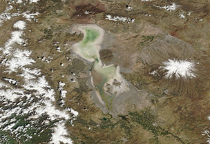
Seated near the Zagros Mountain range in northwestern Iran, Lake Urmia was once the second-largest lake in the Middle East, supporting a rich ecosystem filled with fish, birds, and plants, and held shores studded with tourist centers and hotels. Concerns about how excessive water use and drought might affect the lake were expressed as early as the 1970s. Only eight permanent rivers flow into the lake, and more than 50 dams have been constructed on those rivers, severely reducing water flow into the lake.
In 2015, estimates from satellite imagery showed that the lake had lost about 88 percent of its size between 2006 and 2015. In 2016, Scientific American published an interview with Iranian botanist Hossein Akhani, who described the changes he had seen over years visiting the lake. In 1987, he first visited to perform studies in the saline waters of Lake Urmia. When asked when he realized the lake was shrinking, he replied, “In 2001, when I visited the northeastern part of the lake to collect plants, I saw that the lake is receding and there were many areas where the salt was exposed to earth. It was completely different from what I saw in 1987.”
Lake Urmia has continued to shrink, and today is barely a mineral-encrusted remnant of its former self. The complete loss of this lake would be tragic in many ways, from the flamingos who feed on the unique crustaceans that live in the saline waters, to the loss of biodiverse wetlands, to the damage to agriculture in the basin. In addition, the mineral crust and bottom sediments contain not only salt, but heavy toxic metals used in industry and toxic agricultural substances. As the lakebed is exposed and desiccated, these may become airborne and pose a risk to the environment and people.
In response to the shrinking of this valuable resource, the Urmia Lake Restoration National Committee (ULRNC) was established in 2013 to study and fund a response to slow water loss and try to restore at least some water to the lake. In 2016, the Committee approved more than 80 projects in the basin, including release of water from dams and plans to create a canal to bring water into Urmia. In mid-February 2023, a long-delayed project designed to divert water from the Kanisib Dam in the West Azarbaijan province finally began to carry water. The project consists of a 40 km long tunnel and 17 km long canal, and promises to bring at least a little water to the shriveling lake.
The Moderate Resolution Imaging Spectroradiometer (MODIS) on board NASA’s Terra satellite acquired two true-color images of Lake Urmia, one on March 29, 2023, and another on April 14, 2001. For today's Image of the Day, the two different images fade into each other to help illustrate the dramatic changes over time. In the center of each image is a dark round area. This is an inactive volcano. At one time, Lake Urmia completely surrounded the volcano, so that visitors would have to take a boat to reach it. Even in the earliest (2001) image, waters had receded so dramatically that the volcano would be easily accessible by any tourist, with no risk of getting their shoes damp.
Image Facts
Satellite:
Terra
Date Acquired: 3/29/2023
Resolutions:
1km (94.6 KB), 500m (226 KB), 250m (162.5 KB)
Bands Used: 1,4,3
Image Credit:
MODIS Land Rapid Response Team, NASA GSFC
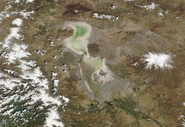
