1. Introduction
Coastal lagoons are water bodies found on every continent, typically running parallel to the coastline. They are separated from the ocean by natural barriers and connected through narrow inlets that occasionally allow water exchange. These environments are widely recognized as invaluable ecological habitats worldwide that provide essential ecosystem services such as fisheries, aquaculture, and agriculture [
1,
2]. However, they face various challenges globally due to socio-economic interests, leading to increased human pressures and the consequent overexploitation of natural resources, as well as environmental degradation in the forms of pollution, eutrophication, urbanization, and other changes [
3,
4,
5].
This study focuses on the specific case of the Moulay Bousselham lagoon, situated on the Atlantic coast of Morocco. It is the largest wetland in the country and serves as a critical site for migratory birds during their stopovers and wintering periods. Recognizing its ecological significance, the lagoon was designated as a “permanent biological reserve” by Ministerial Order No. 223-78 on 3 March 1978, and subsequently listed as an internationally important site for biodiversity and ecology under the Ramsar Convention in 1980.
Despite the numerous studies conducted that contribute to the conservation of the lagoon’s resources [
6,
7], the substantial influence of the local population poses a significant threat to the long-term balance and availability of these resources. The extensive expansion of human activities, including pollution, intensified agriculture, urban pressures, overgrazing, and excessive exploitation of water and plant resources, has resulted in the reduction of natural habitats within the lagoon, leading to a decline in biological diversity and an impact on ecological integrity [
8]. Additionally, the excessive use of fertilizers and pesticides in adjacent agricultural areas, along with the discharge of wastewater from highways, contribute to eutrophication and contamination of the lagoon’s water and sediments, including hydrocarbons and heavy metals [
9,
10].
At present, the Moulay Bousselham lagoon faces a significant challenge of sedimentation, particularly in the inlet zone, leading to the formation of sand deposits. This poses a considerable risk of inlet closure, which, in turn, would result in various environmental issues and ultimately the loss of the lagoon itself.
Considering the multitude of pressures impacting the lagoon, this study aims to analyze the causal relationship between driving forces, pressures, impacts, states, and responses using the DPSIR framework. In this way, practical solutions and options can be proposed, facilitating informed decision-making for the sustainable management of this ecosystem to achieve “blue growth”—a concept encompassing sustainable economic development associated with marine and coastal resources.
2. Materials and Methods
2.1. Study Procedures
The DPSIR model was adopted as an analytical framework in our study to monitor and understand the changes occurring in various aspects of the Moulay Bousselham lagoon’s structure and functioning over time [
11,
12,
13]. This approach allowed us to identify the underlying drivers of these changes, evaluate their impacts on water quality and hydrodynamic balance, and assess the overall state of the ecosystem.
The drivers identified in our study included human population growth associated with tourism and urban development, as well as economic activities such as fisheries production and agricultural development [
11,
13]. These drivers exerted significant pressure on the lagoon, leading to resource overexploitation and the introduction of heavy metal pollutants.
To comprehensively analyze the lagoon’s state, we assessed the physical, chemical, and biological conditions within the ecosystem [
14]. By examining these changes, we were able to determine their negative ecological and socio-economic impacts.
In response to these challenges, various measures were undertaken to address the changes in hydrodynamics and water quality. These efforts encompassed the control of pollutant discharges, the implementation of conservation initiatives, and the establishment of sustainable management practices aimed at safeguarding the natural resources of the Moulay Bousselham lagoon [
11,
13].
Figure 1 illustrates the flow chart of our study, depicting the sequential steps of interpreting drivers and pressures, describing state changes, evaluating impacts, and reviewing the human response. As one of the four Moroccan sites considered by the Ramsar Convention for the conservation of wetlands of international interest, the Moulay Bousselham lagoon is subject to intense urbanization and economic activities, which necessitate proactive measures to protect its delicate ecological balance.
2.2. Presentation of the Site
The Moulay Bousselham lagoon, also known as “Merja Zerga,” is a coastal environment situated on the Atlantic Ocean at approximately 34°47′ N, 6°13′ W to 34°52′ N, 6°14′ W (
Figure 2). Spanning a length of 9 km and a width of 5 km, it features an inlet that is 357 m wide, facilitating water exchange between the lagoon and the Atlantic Ocean, thus ensuring the lagoon’s water renewal. Since 1980, the Moulay Bousselham lagoon has held the prestigious status of being a Ramsar site. Designated under the Convention on Wetlands of International Importance, it has also been recognized by the Ministry of Water and Forests as a Site of Biological and Ecological Interest (SIBE). Furthermore, the lagoon is included in the coastal monitoring network of the National Fisheries Research Institute. Renowned for its exceptional biodiversity, the Moulay Bousselham lagoon serves as a remarkable habitat for numerous bird species. It stands as one of the most significant lagoons in Morocco, attracting attention for its ecological value and natural splendor.
3. Findings and Discussion
The outcome of the application of the DPSIR approach on the Moulay Bousselham lagoon is the result of a detailed analysis of data and information previously presented in the scientific literature (reports, studies, articles, theses, etc.), followed by the identification of the main issues of this area, the decomposition of these issues using the five components of DPSIR (driving forces, pressures, state, impact, and responses), and finally the mapping of these issues to facilitate decision-making.
The following section presents the decomposition of the environmental and socio-ecological issues of the Moulay Bousselham lagoon through the DPSIR model.
3.1. Driving Forces and Pressures Analysis
3.1.1. Population Growth and Land Use Change
Moulay Bousselham is an important urban pole on the Moroccan Atlantic coast. The user population of the lagoon comes under the province of Kenitra and is divided between the communes of Moulay Bousselham and Bahara Oulad Ayad. The demographic situation of the two municipalities studied over the past two decades reflects their evolution and provides information on their prospects. Between the census in 2004 and that in 2014, the populations of the two rural communes have evolved at significantly different rates, with an average annual growth rate of 2.2% for the commune of Moulay Bousselham and 1.5% for the commune of Bahhara Oulad Ayad for the period 2004–2014.
3.1.2. Economic Sectors
Economic development has led to the expansion of and increase in human activities and has been one of the main anthropogenic factors in resource use and land use/habitat. The main activities are agriculture and fishing (
Table 1). However, other complementary activities are practiced, such as mat-making from rushes, livestock raising, and wage labor, which vary according to the resources available (
Table 1).
Human activities, including resource exploitation and agriculture, deliver several pollutants, such as insecticides, pesticides, and fertilizers used in vegetable crops around the lagoon and in the lagoon [
10]. Consequently, this lagoon is threatened by three main environmental problems: (i) sediment imbalance (flow velocity in the channels higher than the reflux velocity), which remains the main factor in the degradation of the water and the ecosystem of the lagoon; (ii) the overexploitation of natural resources (fishing, agriculture, etc.); and (iii) water pollution.
3.1.3. Silting and Coastal Erosion
Over time, the dune cordon has undergone many changes (silting and erosion), particularly in its position of communication with the sea. Indeed, the periods of communication alternate more or less regularly with the periods of total closure of the lagoon.
3.1.4. Pollution
The management of the “Merja” space appears to be a common and conflicting issue between the various activities. The risks of degradation and pollution of resources are all-pervasive and constitute a real threat to the ecological balance and hydrological functioning of the lagoon area of the MZ. Indeed, water pollution, especially from agricultural activities (contamination of water by pesticides and fertilizers), remains critical, and its impacts are greatest on the health of the lagoon area of the MZ in general and on the bird population in particular.
3.2. Analysis of States
3.2.1. Physical and Sedimentological State
Current velocities in the Moulay Bousselham lagoon are controlled by two hydrodynamical regimes: (i) during the flood tide: when the sea water pushes in, the force of the currents is concentrated on the shoals and the passes (1 m/s) as well as on the gently sloping banks; (ii) during the ebb tide: depending on the volume of water entering the Merja at the time of the flood, the current is more important in the deep areas than in the superficial parts (0.1 to 0.3 m/s) [
15].
Moreover, the strength of the northeastern current remains constant (0.55 m/s) throughout the year, whereas the spring tides are more powerful in the summer (0.9 m/s) than in the winter (0.75 m/s) [
15].
3.2.2. Biological State Changes
Merja Zerga is a Ramsar area; it is characterized by a particular hydrological regime (tidal and continental influences) and by the great diversity of its habitats. This lagoon is one of the largest coastal wetlands in Morocco. Mainly in relation to its ornithological importance, this site has been classified as a site of biological and ecological interest (SIBE) [
16].
The Merja Zerga encompasses a large variety of wetland habitats characterized by the presence of important floristic diversity.
3.3. Analysis of Impacts
Wetlands in all countries, especially those threatened by the intensification of human activities, as is the case with the Merja Zerga lagoon, are experiencing enormous negative impacts. Hydrology plays a fundamental role in the maintenance and creation of these environments, but the lack of specific measures relating to the hydrological aspects of wetlands means that there is little knowledge and few established models of operation.
Thus, the management of the space “Merja” is considered a common and conflicting issue among the various activities. The risks of degradation and pollution of resources are pervasive and constitute a real threat to the ecological balance and hydrological functioning of the lagoon space of the MZ.
In effect, water pollution, especially that caused by agricultural activities (contamination of water by pesticides and fertilizers), remains the most critical, and its repercussions are stronger on the health of the lagoon of the MZ in general and on the avifauna in particular [
17].
Globally, the hydrological and essentially chemical problem evident in this lagoon is linked to the pressure generated by the upstream inputs, which are highly charged with chemical substances linked to agricultural practices using fertilizers and phytosanitary products, on the natural environment [
18]. Thus, the site remains sensitive to the developments and to the different speculations, in particular the different agricultural practices bordering it, which represent a perennial nuisance.
3.4. Analysis of Responses
Environmental quality plays a pivotal role in the development of various essential sectors and can significantly impact the sustainability of natural resources if it becomes compromised [
12]. Without an integrated strategy for sustainable development that takes into account both environmental factors and socio-economic programs, the degradation of natural resources will continue and jeopardize the concept of sustainability [
12].
One of the crucial measures for preserving the lagoon’s integrity is the establishment of a wastewater treatment plant, encompassing pre-treatment, biological treatment, and advanced tertiary treatment processes, including low-pressure closed-loop ultraviolet disinfection. The primary objective of this project, as stated by Biwater’s Country Manager for Morocco, is to protect the Merja Zerga lagoon reserve, which serves as a vital bird habitat, attracting birdwatchers from around the globe, as well as safeguarding the Moulay Bousselham beach by preventing the discharge of wastewater. Such discharge can lead to biological disturbances, causing reproductive, growth, or immune system disorders in aquatic organisms.
Moreover, the treated wastewater can be effectively utilized for irrigation purposes in the region, which is renowned for its agricultural activities, including the global export of strawberries.
Recognizing the magnitude of the pollution issue affecting the Moulay Bousselham lagoon and despite the significant decline in agricultural activity, the Ministry of Agriculture and Maritime Fishing has established a commission comprising representatives from the Directorate of Sectors, the Directorate of Irrigation and Development of the Agricultural Space, the Agency for Agricultural Development, and the ORMVAG. This commission has been tasked with identifying and evaluating an action plan to address the challenges at hand. The primary objectives of this action plan are as follows: (i) to eliminate all potential sources of microbial or chemical contamination resulting from agricultural activities, such as grazing in the lagoon, nitrate leaching, and pesticide residues; (ii) to contribute to the environmental protection of the lagoon; and (iii) to implement alternative solutions that benefit the farmers concerned.
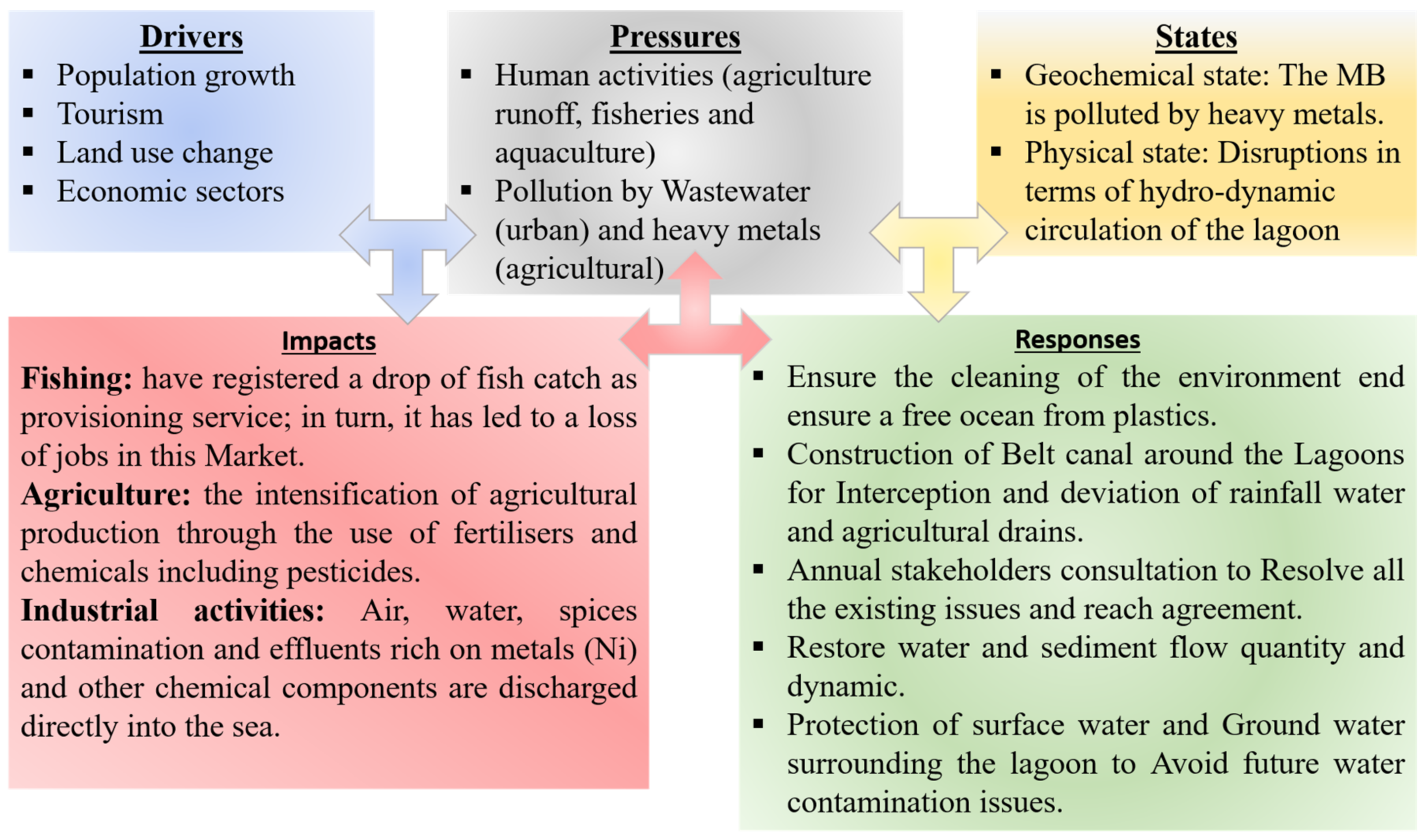
3.5. DPSIR Model of the Moulay Bousselham Lagoon
The aim of managing water resources and quality is to safeguard human health while maintaining sustainable aquatic and associated terrestrial ecosystems. It is therefore important to quantify and identify the current state of ecosystems and evaluate their impacts on water environments.
For analyzing environmental conditions and vulnerabilities, especially lagoons as a socio-ecological system (SES), conceptual models are required to organize, visualize, understand, and clarify the issues concerning actual or predicted conditions and how they might be explained and solved [
19]. They can be considered as representing organizational schemas that recapitulate information in a standard, logical, and hierarchical manner. As is the case for the following DPSIR analysis (
Figure 3), it provides a summary of the different sources of degradation of the Moulay Bousselham lagoon, including pressures, states, impacts, and responses.
4. Conclusions
Using DPSIR as a framework for study, this paper traced the recurrent changes in the Moulay Bousselham lagoon and their causes and impacts. Indicators of factors, pressures, states, impacts, and responses were used to assess the changes in Moulay Bousselham lagoon. It can be concluded that pressures from human population growth and economic development have increased over the last half century in the Moulay Bousselham lagoon, Morocco. The overexploitation of natural resources, agriculture, selfish aquaculture, and water pollution have directly caused many physical, chemical, and biological degradations of the state of the Moulay Bousselham lagoon and have resulted in several negative ecological and socioeconomic impacts, including water pollution, sediment pollution by heavy metals, and the disruption of hydrodynamic circulation. Human efforts have been made to protect the Moulay Bousselham lagoon, such as the installation of a wastewater treatment station, environmental education and awareness (the creation of an information center), and scientific support capacity.
Finally, it can be noted that the DPSIR model serves as a multi-disciplinary approach that has allowed us to trace the links between the socioeconomic activities, their impacts on the sustainability of the lagoon, and the human interventions to reduce them, supporting the creation of a strategic vision to improve the ecological productivity of the Moulay Bousselham lagoon, ensure the sustainability of its natural resources, and integrate the management of this ecosystem.


 ,
, 


