


-
-
-
About
Introduction to District
History & Tradition
Geographical and Economic
-
Administration
Deputy Commissioner
Office of the Deputy Commissioner
About Sections
DDLG/ADG
Local Government Section
Officers and Employees
Office Order
-
Government offices
Law-Discipline & Security Issues
-
□ Office of the Police Superintendent
-
□ Sylhet Metropolitan Police
-
Tourist Police, Sylhet Region
-
□ Rapid Action Battalion (RAB) -9
-
□ Fire service and Civil Defense
-
□ Department of Narcotics Control
-
□ Sylhet Central Jail
-
□ Ansar & VDP
-
□ BGB
-
□ Department of National Consumer Rights Protection
-
District Legal Aid Office
Information & Communication Technology
Agriculture & Food Related Issues
-
Department of Agricultural Extension, Sylhet.
-
District Agriculture Information Service Office
-
District Food Office
-
Safe Food Authority, Sylhet
-
District Livestock Office
-
District Fisheries Office
-
Joint Director (Seed Marketing), BADC, Sylhet
-
Deputy Director (Seed Marketing), BADC, Sylhet
-
BADC (Irrigation Wing)
-
Office of Senior Agriculture Marketing Officer, Sylhet
-
Soil Resources Development Institute, Sylhet
-
District Artificial Insemination Center
-
Plant Quarantine Station, Landport, Jokigonj, Sylhet
Education & Culture
-
□ Secondary and Higher Secondary Education Board
-
□ District Education Office
-
□ District Primary Education Office
-
□ District Bureau of Non-formal Education
-
□ District Shilpakala Academy
-
Bangladesh Shishu Academy
-
□ District Sports Office
-
□Govt. Teachers Training College
-
Primary Teachers Training Institute, Sylhet
-
□ Divisional Government Public Library
-
Sylhet Technical Training Center
Health Related
Engineering & Communication
-
District Public Works Department office
-
District BTCL Office
-
Regional News Organization, Bangladesh Betar Sylhet
-
District Local Govt Engineering Office
-
Sylhet Zonal Office
-
Road Divisdion, Sylhet
-
District Public Health Engineering office
-
Education Engineering Department, Sylhet
-
District Electricity Development Board Office
-
Sylhet Gas Fields Limited
-
PDB1, sylhet
-
PDB 2, Sylhet
-
PDB 3, Sylhet
-
PDB 4, Sylhet
-
Sylhet Palli Bidyut Samity-1
-
Sylhet Palli Bidyut Samity-2
-
District Water Development Board Office
-
District BRTA Office
-
District Post Office
-
Urban Development Directorate
-
Superintending Officer, LGED,Sylhet Region,
About Human Resources Development
-
District youth development officer, sylhet
-
District Relief & Rehabilitation Office
-
District Social Services Office
-
Office of the Deputy Director, Department of Women Affairs, Sylhet
-
District Statistics Office
-
District Rural Development Office (BRDB)
-
□ District Social Welfare Office
-
□ District Co-operative Office
-
District Manpower and Employment Office, Sylhet
-
District Islamic Foundation Office
-
□ Regional-Labor-Office
-
Palli Daridro Bimochon Foundation
-
sorkari sisu poribar(balok), Sylhet
-
sorkari sisu poribar(balika), Sylhet
-
Forestry Science and Technology Institute
Other Offices
-
□ Bangladesh Investment Development Authority
-
District Regional Passport Office
-
Small Farmer Development Foundation, Regional Office, Sylhet
-
District Information Office, Sylhet
-
Bangladesh Betar, sylhet
-
District Register Office
-
District Small and Cottage Industries Corporation
-
Office of the Assistant Controller of Imports and Exports, Sylhet
-
District Forest Office
-
□ Office of the Police Superintendent
-
Local Government
City Corporation
District Council
Upazila Council
Union Council
-
Other Organizations
Educational Institutions
Organization/Association
Banks/Financial institutions
Religious Institution
Others Organization
- E-Services
- Gallery
- Bijoy Phool
- National Anthem
-
Covid 19
Hospitals
- BIDA
-
-
-
About
Introduction to District
History & Tradition
Geographical and Economic
-
Administration
Deputy Commissioner
Office of the Deputy Commissioner
About Sections
DDLG/ADG
Local Government Section
Officers and Employees
Office Order
-
Government offices
Law-Discipline & Security Issues
- □ Office of the Police Superintendent
- □ Sylhet Metropolitan Police
- Tourist Police, Sylhet Region
- □ Rapid Action Battalion (RAB) -9
- □ Fire service and Civil Defense
- □ Department of Narcotics Control
- □ Sylhet Central Jail
- □ Ansar & VDP
- □ BGB
- □ Department of National Consumer Rights Protection
- District Legal Aid Office
Information & Communication Technology
Agriculture & Food Related Issues
- Department of Agricultural Extension, Sylhet.
- District Agriculture Information Service Office
- District Food Office
- Safe Food Authority, Sylhet
- District Livestock Office
- District Fisheries Office
- Joint Director (Seed Marketing), BADC, Sylhet
- Deputy Director (Seed Marketing), BADC, Sylhet
- BADC (Irrigation Wing)
- Office of Senior Agriculture Marketing Officer, Sylhet
- Soil Resources Development Institute, Sylhet
- District Artificial Insemination Center
- Plant Quarantine Station, Landport, Jokigonj, Sylhet
Education & Culture
- □ Secondary and Higher Secondary Education Board
- □ District Education Office
- □ District Primary Education Office
- □ District Bureau of Non-formal Education
- □ District Shilpakala Academy
- Bangladesh Shishu Academy
- □ District Sports Office
- □Govt. Teachers Training College
- Primary Teachers Training Institute, Sylhet
- □ Divisional Government Public Library
- Sylhet Technical Training Center
Health Related
Engineering & Communication
- District Public Works Department office
- District BTCL Office
- Regional News Organization, Bangladesh Betar Sylhet
- District Local Govt Engineering Office
- Sylhet Zonal Office
- Road Divisdion, Sylhet
- District Public Health Engineering office
- Education Engineering Department, Sylhet
- District Electricity Development Board Office
- Sylhet Gas Fields Limited
- PDB1, sylhet
- PDB 2, Sylhet
- PDB 3, Sylhet
- PDB 4, Sylhet
- Sylhet Palli Bidyut Samity-1
- Sylhet Palli Bidyut Samity-2
- District Water Development Board Office
- District BRTA Office
- District Post Office
- Urban Development Directorate
- Superintending Officer, LGED,Sylhet Region,
About Human Resources Development
- District youth development officer, sylhet
- District Relief & Rehabilitation Office
- District Social Services Office
- Office of the Deputy Director, Department of Women Affairs, Sylhet
- District Statistics Office
- District Rural Development Office (BRDB)
- □ District Social Welfare Office
- □ District Co-operative Office
- District Manpower and Employment Office, Sylhet
- District Islamic Foundation Office
- □ Regional-Labor-Office
- Palli Daridro Bimochon Foundation
- sorkari sisu poribar(balok), Sylhet
- sorkari sisu poribar(balika), Sylhet
- Forestry Science and Technology Institute
Other Offices
- □ Bangladesh Investment Development Authority
- District Regional Passport Office
- Small Farmer Development Foundation, Regional Office, Sylhet
- District Information Office, Sylhet
- Bangladesh Betar, sylhet
- District Register Office
- District Small and Cottage Industries Corporation
- Office of the Assistant Controller of Imports and Exports, Sylhet
- District Forest Office
-
Local Government
City Corporation
District Council
Upazila Council
Union Council
-
Other Organizations
Educational Institutions
Organization/Association
Banks/Financial institutions
Religious Institution
Others Organization
- E-Services
- Gallery
- Bijoy Phool
- National Anthem
-
Covid 19
Hospitals
-
BIDA
Website of BIDA
Focal Point Officer (Sylhet District)
Section Officer (Sylhet District)
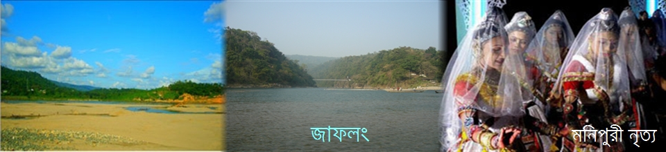
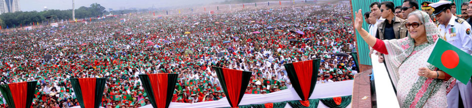
Sylhet district background
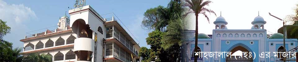
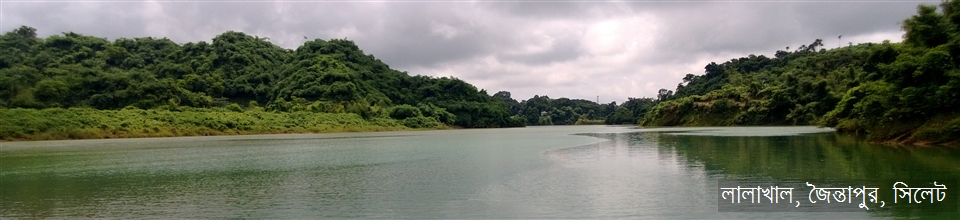
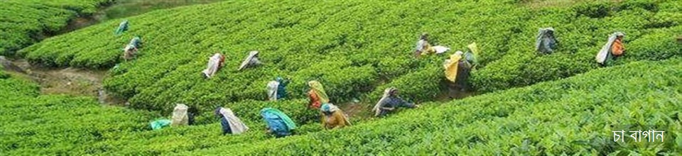
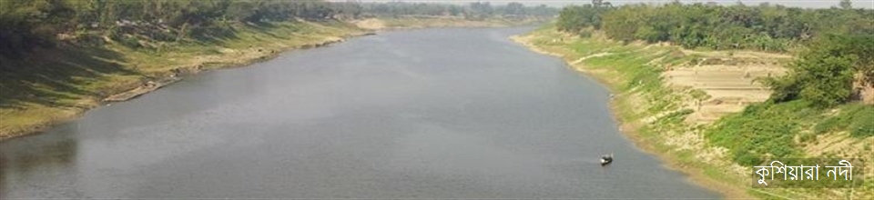
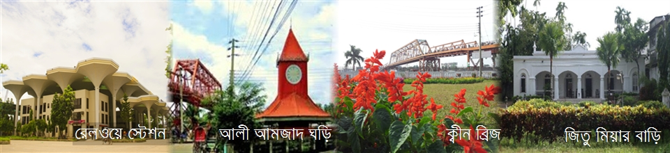
Sylhet is an ancient hometown of 360 Awalis, with the great saint Hazrat Shahjalal (ra) and Hazrat Shahpuran (R). Information about this district is available from the visit of Chinese traveler Hiuen Tsang's 640th anniversary. In the tenth century Maharajah Srichandra, inscribed on the west side of the copper plate, showed that he won this district. Historians believe that Sylhet or Srihatta was known to be a remarkable trade center before long. In 14th century, Sultan of Yemen, Hazrat Shahjalal (R) conquered Sylhet and started preaching Islam. In addition to fighting with the Mughals, Nankar revolt and language movement, the contribution of this district is unprecedented in the liberation war. The famous Muslim traveler Al-Biruni wrote Sylhet as Sylhet in his book 'Kitabul Hind'. It was known from many ancient times that this district was known as 'Sreehatta', according to Hindu mythology, 'Sree' means 'suffix' or 'beauty' and meaning 'hand'. Where Sri Hansen was found, it is Shreehastha, which has been named as Shreehatta in the evolution of time. This area is called Sylhet due to the abundance of stone, which is called Shilah and due to the abundance of stone. Sylhet word sequence means seal and prefix heats means that market is market. Since ancient times, the district stone (shil) and hats (business and commerce) were prevalent, so many people think that the word 'shil' and 'haat' have originated from the word Sylhet. The district was established on 17 March 1772. Until 1874, this district was affiliated with the Dhaka Division. In that year Sylhet was included in the indigenous Assam province. During the partition of the country in 1947, Sylhet district was transferred to East Pakistan after the referendum. Sylhet district was then under Chittagong division. In 1983-84, the greater Sylhet district was divided into 4 new districts and on 1 August 1995 Sylhet division was formed. Sylhet started developing rapidly from the colonial period. After the devastating earthquake of June 12, 1897, the whole city was destroyed, but later the railway connection with the extensive development of Rathaghat. The distinction of the tea garden and the development of the district continued to flourish in the districts of Sylhet from the 1950-60s which is still in progress. There are many haor-bills, small tilah canals in the district, and the Sundma-Kushiyara river. There is a special part of the country's biggest Haor Hakaluki. Agriculture is particularly rich in rice production, the district is rich in natural fisheries. In the northeast corner of the district, the footprint of the Khasia-Jyotimaya mountain. The soil here is particularly suitable for tea cultivation and its beauty is attracting tourists. Sylhet's Jaflong, Lalakhal, Bholaganj, Jimatpur, and other places of tea gardens, and other places of tourism are considered as excellent tourist spots. Besides, Sylhet district is a unique district in natural resources like natural gas, oil, limestone, hard rock, and Balus. Besides attracting mineral resources, attracting foreign tourists will earn a lot of revenue while concentrating in the tourism sector. Not only revenue, but also in the development of the tourism industry, it can be driven in the minds of native tourists, which can create the potential of the country to be dynamic and speedy. Sylhet district: area 3,490.40 sq km. Khasia-Jyotimaya Hills of India on the north, Moulvibazar district on the south, Cachar and Karimganj districts of India on the east, Sunamganj and Habiganj districts on the west. Annual average maximum temperature is 33.20 s, minimum temperature is 13.60 s, annual total rainfall of 3334 mm. Sylhet's main and longest river surma (350 km), the other major river is Kushiyara. There are a total of 82 haor-bills in this district. Among them, Singhua Bills (12.65 sq km), Chatla Bills (11.86 sq km) are worth mentioning. Total reserve for sale in Sylhet 236.42 sq km. Part of the Khasia and the Jyotimaya hills in India are special in the northeast corner of the district. There are several small hills and tilas in Sylhet, among which are Tilah (54 m), Shari Tila (92 m), Lalakhal Tila (135 m), Tila class (77.7 m) of Dhaka South, Sylhet (Sylhet). District town) consists of 27 wards and 210 municipalities. Size 10.49 sq km. Population 285308; Males constitute 54.68%, females 45.32%. Density of population per square kilometer 27224 people Literacy rate among the town people is 66.9%. Sylhet developed rapidly during the colonial era. Sylhet municipality was created in 1878. On 12 June 1897, a severe earthquake almost completely destroyed the entire city. Later on, the European-style, more beautiful and modern city developed on the ruins. In the late 1890s several rastaghat were made. In 1912-15, when the Assam Bengal Railway was connected to Sylhet, a branch of Sylhet was completely eliminated with the other parts of the country. Due to the tea industry, the importance of Sylhet city has increased in the early twentieth century. In the 1950s and 1960s, the urbanization of expatriate Sylhet and Sylhet city started happening and now and it continues. Administration: Sylhet district was established on 17 March 1772. Until 1874, Sylhet district was included in the division of Dhaka Division. On September 12 of that year, Sylhet was connected with the indigenous Assam province. Sylhet was part of Assam since 1947 (excluding the Kaltuku period of partition of Bengal from 1905 to 1911). During the partition of India in 1947, in the referendum, Sylhet district was affiliated with East Pakistan. Then Sylhet was administrative in Sylhet division. Greater Sylhet district during the administrative reconstruction of 1983-84


Planning and Implementation: Cabinet Division, A2I, BCC, DoICT and BASIS
Technical Assistance:
![]()
Developed By: