The Violent Remaking of Appalachia
When mining a century’s worth of energy means ruining a landscape for millions of years.
Central Appalachia’s history is the story of coal. At its peak in the mid-20th century, mining employed more than 150,000 people in West Virginia alone, mostly in the state’s otherwise poor and rugged counties. For decades, the United Mine Workers of America, a muscular, strike-prone union that allied itself with Franklin Roosevelt to support the New Deal, anchored the solidly Democratic highlands where West Virginia meets eastern Kentucky and Virginia’s western-most tip. In 1921, during the fight to unionize the region’s mines, ten thousand armed miners engaged strike-breakers and an anti-union militia in a five-day gun battle in which more than a hundred people were killed. The Army arrived by presidential order and dispersed the miners, dealing a decade-long setback to the UMWA.
Today, after decades of mechanization, there are only about twenty thousand coal miners in West Virginia, and another sixteen thousand between Kentucky and Virginia. The counties with the greatest coal production have some of the region’s highest unemployment rates, between 10 and 14 percent. An epidemiological study of the American opiate overdose epidemic found two epicenters where fatal drug abuse leapt more than a decade ago: one was rural New Mexico, the other coal country.
Although jobs have disappeared, Appalachia keeps producing coal. Since 1970, more than two billion tons of coal have come from the central Appalachian coalfields (A-B). West Virginians mined more in 2010 than in the early 1950s, when employment peaked at nearly six times its current level. Back then, almost all coal miners worked underground, emerging at the end of their shifts with the iconic head-lamps and black body-paint of coal dust. In the 1960s, mining companies began to bulldoze and dynamite hillsides to reach coal veins without digging. This form of strip-mining, called contour mining, caused more visible damage than traditional deep mining, leaving mountains permanently gouged and, sometimes, farmland destroyed.
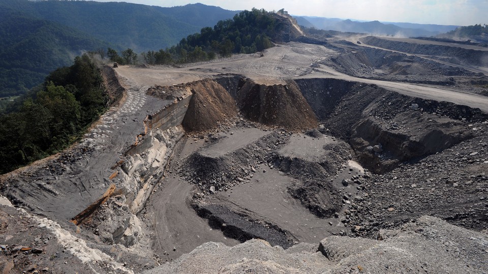
Today, contour mining seems almost artisanal. Since the 1990s, half the region’s coal has come from “mountaintop removal,” a slightly too-clinical term for demolishing and redistributing mountains. Mining companies blast as much as several hundred feet of hilltop to expose layers of coal, which they then strip before blasting their way to the next layer. The giant cranes called draglines that move the blasted dirt and coal stand twenty stories high and can pick up 130 tons of rock in one shovel-load. The remaining rubble, called overburden, cannot be reassembled into mountains. Instead, miners deposit it in the surrounding valleys. The result is a massive leveling, both downward and upward, of the topography of the region. According to Appalachian Voices, an advocacy organization, mining has destroyed more than 500 mountains.
The Appalachian coalfields were formed from swamps that, 310 million years ago, covered the region. Some quarter of a billon years ago, tectonic forces thrust the region upward to form a plateau, which has been since shaped mainly by erosion. Accordingly, it is a land of waterways. Its place-names reflect this: Alum Lick, Barren Creek, Frozen Run, Left Hand, Stone Branch.
The webs of trunks and tributaries form one half of the spatial logic of the region, alongside the ridges that split them into watersheds. A walk that would take miles along creek bottoms is a quick, if arduous, scramble over a ridge. A misstep descending a ridge can put a walker in the wrong hollow, following an unforeseen stream.
Although precise tallies are elusive, Environmental Protection Agency reports suggest that valley fills have buried over two thousand miles of “headwater streams,” the small, sometimes intermittent flows through leafy forest floors and rhododendron groves where waterways pick up nutrients and other organic matter that supports life downstream. In 2011, the EPA estimated that mining had altered 7 percent of the surface area of the central Appalachian coalfields. In 2012, it estimated that 1.4 million acres of native forest had been destroyed, and was unlikely to recover on the broken soils that mining leaves.
A study from three Duke University researchers, published in early February in Environmental Science and Technology, attempts a landscape-scale accounting of the transformation of Appalachia. Using detailed satellite data for a 4,400 square-mile portion of southeastern West Virginia (a bit less than a quarter of the coalfield region and somewhat under 20 percent of West Virginia’s total area), they describe a terrain that has been broken and transformed. Active and abandoned mining sites occupied 10 percent of the region. In those sites, rubble filled valleys to depths of six hundred feet. Blasting and bulldozing had lowered ridges and mountaintops by as much as six hundred feet as well. A steep terrain with sharp contrasts between high ridges and low, stream-cut bottomland is becoming a muddled average of its original topography.
Where it has not been subjected to mountaintop removal, Appalachia is a region of slopes. There is precious little level ground aside from narrow ridgelines and narrower valleys (locally called hollows). In the 10 percent of the study area that has been mined, a terrain dominated by steep hillsides has been replaced by a mix of plateaus with remnant or reconstructed hillsides that are shorter and blunter than before mining. The most common pre-mining landform was a slope with a pitch of 28 degrees, about as steep as the upper segments of the cables of the Brooklyn Bridge. Today, the most common is a plain with a slope of 2 degrees, that is, level but uneven. Across the entire study region, mining has filled a steep landscape with pockets of nearly flat ground.
The researchers estimate conservatively that the volume of central Appalachian earth and rock turned from mountain to valley-fill is equal to the amount of ash and lava that spewed from the Philippines’ Mount Pinatubo in 1991, about 6.4 billion cubic meters. For comparison, that is 32 times the volume of material that the 1980 Mount Saint Helens eruption deposited in the northern Cascades. (In an email, Matthew Ross, the lead author on the study, speculated that a fuller accounting of overburden might double or triple the researchers’ estimate. He noted that 6.4 billion cubic meters would cover Manhattan in 240 feet of earth and rock.)
The region’s hydrology has been transformed. Because streams begin on mountainsides, and it is mountains that are being mined, this means that the region’s headwaters have been transformed. In place of mountains formed from layers of solid rock and coal, with a thin layer of dirt at the surface, there are now deep sinks full of compacted rubble, which works as a sponge. The researchers calculate that the valley fills can hold a year’s worth of rainfall, ten times more than the thin, clay-rich pre-mining soils.
As water lingers in the porous fills, it takes up chemicals from the shattered rock. It also absorbs alkalinity from carbonate stone that mining companies deliberately mix into overburden to prevent the disturbed stone from producing acidic runoff, which has turned many streams in mining regions bright orange and lifeless. In the study region, streams emerging from valley fills are as much as an order of magnitude more alkaline than neighboring streams, and also show high levels of toxic selenium. The streams are not dead, unlike those in acid-runoff watersheds, but the mining pollutants reduce fish and plant life well downstream of the valley fills.
Coal is an inexpensive source of energy, economically speaking, and a costly one in ecological terms. Its carbon emissions are the highest of any energy source. In 2012, coal accounted for 25 percent of American greenhouse gas emissions and 44 percent of global carbon emissions. In the past few years, atmospheric carbon has continued its upward climb and now averages over 400 parts per million. It was only around 1990 that it passed 350 parts per million, the number scientists have converged on as the threshold of potentially catastrophic climate change.
Twice, in 1999 and 2002, federal district courts in West Virginia found that valley fills violated legal duties to protect streams. In 2001 and 2003, the federal appeals court in Richmond, Virginia, reversed those decisions, allowing valley fills to go forward. During the decade after federal courts allowed mountaintop removal to continue, about half of America’s electricity came from coal, while China’s boom raised global coal demand much as it raised prices for other industrial building-blocks, such as steel and concrete.
Those booms seem to be over. On February 9, the federal Energy Information Agency reported that January had seen the lowest levels of American coal production since 1983. American power companies have replaced coal with natural gas, which is now cheaper than coal, thanks to new (and controversial) drilling techniques. Coal’s share of American electricity production fell from about half in 2006 to just over a third in 2015. Chinese coal demand has gone from rapid growth a few years ago, which drove up the value of coal companies, to outright decline.
The FIA report found the largest decline in production in Appalachia, and predicted that coal mining there would fall a further 8 percent over 2016. On February 22, the Rhodium Group, a consultancy, reported that the combined market value of the largest four American mining companies had fallen from a 2011 peak of $34 billion to just $150 million. Two of the four, Arch Coal and Alpha Natural Resources, filed for bankruptcy last year.
A gift from the Mesozoic to the Industrial Age, source of London’s pea soup fogs and of violent labor strikes before the New Deal, coal can feel anachronistic in the twenty-first century. It powered an older generation of iconic factories—the steel Mills of Gary and Alliquippa—and a fading kind of community among workers. Miners’ unions were the spine of the British Labor Party and arch-Democratic Appalachia. Today the remnants of these towns and villages lean to Donald Trump and the similarly nationalist U.K. Independence Party.
But American coal, right now, is riding out one of its great booms—by quantity, the biggest yet, and, to judge by trends, perhaps the biggest there will ever be. Coal, more than any other fuel, does harm where it is burned, and where it is dug. And geology is forever, at least compared to the lives of people and nations. Many other environmental harms yield in a lifetime as toxins disappear and ecological health returns. After Congress passed the Clean Water Act in 1972, waterways that had been devastated by pollution recovered rapidly. Lake Erie and the Hudson River still hold massive toxic deposits in their silty bottoms, but their fish and plant life have returned, and they are officially open for swimming. Even coal’s killer fogs pass and take with them acid’s erosion of statues and buildings. But Appalachian streams will be flowing from the broken, heaped stone of valley fills for millions of years.
Because mountaintop removal’s harms go so deep and last so long, they make archaic-feeling coal an ironic emblem for “the Anthropocene,” our geologic epoch, when humanity has become a force in the development of the planet. Both mountaintop removal and climate change, the iconic crisis of the age, are geological, changes in chemistry and physical structure of the Earth. Both tell us that we are no longer just scratching the surface, but instead working in our changes very deep, where they will not come out soon. The remaking of the Appalachian landscape, which has moved so much ancient carbon from underground into the planet’s fast-heating atmosphere, is a tractable lesson in the way that this global upheaval is formed of many smaller upheavals and ruined places.